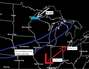
An area of low pressure will continue to develop over the Southern Plains over the next 24 hours. This system will then lift to the NE, reaching the Detroit area by Saturday evening. Warm air out ahead of this low, with colder air (not that cold though) behind the low, while an upper trough swings ENE across the Rockies. This system will spread a swath of snow across parts of the Midwest and Southern Great Lakes region from Friday into Saturday, spreading from SW-NE.
Although the Northland won’t get any snow directly from this system passing through the Midwest, the low passing to the SE of our area will cause winds to shift to a northeasterly direction on Friday and Saturday, and with a cooler air mass moving in, we should see some lake effect snow showers develop especially along the South Shore of Lake Superior Friday afternoon through Saturday. Model guidance today has trended slightly cooler with the 850mb temps late Friday and Saturday (-6 to -12C) while lake water temps are right around +3 to +4C, so we do have enough of a difference between air temps and water temps to activate the lake effect machine, but this still doesn’t look like a major lake effect snow event for the South Shore.

Another case where you look at the water vapor loop from today thinking that the Northland is about to get hit by a winter storm, but this won’t be the case again as this system passes well south of our local area over the next few days.
Note: Water vapor loop time 3:21 PM to 5:16 PM CT, Thursday, December 10, 2020.
Source: https://www.star.nesdis.noaa.gov/

Here’s a look at the 18z NAM 3km simulated radar forecast valid from 9 AM Friday to Midnight Sunday. This model does show an area of generally light lake effect snow developing and impacting the South Shore, possibly as far west as Duluth and Superior from late Friday into Saturday.
Note: If we do get a little snow in Duluth it looks to be sometime Friday evening into Saturday morning, this is when winds will be most favorable (ENE direction) By Saturday afternoon winds become N-NE shifting any lake effect snow potential east of Duluth.
Source: https://weather.cod.edu/

Here’s my snowfall accumulation forecast valid Friday afternoon through Saturday.
- Less than 1″ for Duluth and Superior.
- 1″ to as much as 3″ east of the Twin Ports, including Lake Nebagamon, Port Wing, Bayfield, Washburn, Ashland, Iron River, Upson and Hurley.

Tim
Leave a Reply