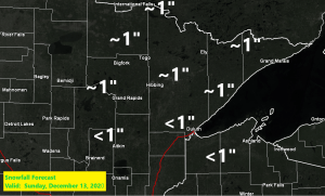
- An inch or less of snow is forecast across the Northland on Sunday, with the snow spreading from west to east, reaching the Twin Ports mid to late afternoon.
- Brief arctic dump Sunday night into Tuesday, with subzero lows possible Sunday night/Monday morning, and again Monday night/Tuesday morning.
- Daytime highs Monday and Tuesday only in the single digits and teens (feeling like December, finally, but it won’t last)
Here comes our Sunday snow as a disturbance (source of lift) moves quickly to the east out of North Dakota and over the Northland (black outlined area on map)
Source: 18z NAM model 500mb vorticity forecast; https://www.tropicaltidbits.com/

Timing Sunday’s minor snowfall event
- Begins in far western portions of the Northland (I’Falls to Brainerd line) ~10 AM to Noon Sunday.
- Reaches Duluth and Superior ~2 PM to 4 PM Sunday.
- Snow shouldn’t last more than 1-3 hours at any given location across the Northland.
18z HRRR model simulated radar forecast valid from 6 AM Sunday to Midnight Monday.
Source: https://weather.cod.edu/

One thing which has been lacking so far this month besides snow is arctic air (subzero temps) There is some potential for subzero lows in parts of the Northland early in the week ahead, but this shot of arctic air won’t stick around long as milder air floods right back into the area by mid to late week the way it looks now.
Source: https://www.tropicaltidbits.com/

Anyone who has followed my blog long enough knows how much I hate a split flow, and this is the kind of pattern we’ve been in for weeks (nothing changes as the pattern locks into place) This is at least one reason as to why it’s been so quiet and dry across the Northland since about mid-November as low pressure systems pass north and well south of our area due to the jet streams which are not in favorable locations to bring a more significant system to our area. I don’t see this pattern breaking down anytime soon, so although we do have a few chances for snow in the coming week, none of them look significant, heck I’ll be shocked if we get more than a half inch to an inch of snow out of any of them over the next 5 days.
Below normal precipitation is forecast across the Northland through the end of December.
Note: The fun zone if you like stormy weather will remain across the Southern Plains, Ohio Valley and eastern U.S., and also across the Pacific northwest.
Source: 12z Euro ensemble model; https://weathermodels.com/

An active weather pattern in the week ahead, but the major storms won’t be impacting the Northland as they stay well to our south from the Southern Plains to the northeast U.S.
Water vapor loop from Saturday, December 12, 2020 (loop time 1:01 PM to 4:56 PM CT)
Source: https://www.star.nesdis.noaa.gov/

Source: https://www.pivotalweather.com/

Several inches of snow are expected to accumulate across parts of Oklahoma, Kansas and Texas Panhandle through Sunday evening.
Source: https://www.pivotalweather.com/

What a warm December so far across the Northern Plains and upper Midwest where average monthly temperatures are running anywhere from 10 to as much as 20 degrees warmer than normal thru December 11, incredible!
Source: https://lab.weathermodels.com/

| December 2020 average temperature and departure from normal (thru the 11th) Note: So far in December 2020, the average temperature at Brainerd, International Falls and Hibbing are running ahead of their warmest December on record, with International Falls nearly 4 degrees warmer than their warmest December on record which was set in 1913, but we still have a little less than 3 weeks to go in December 2020 so will see where will end up at the end of the month. Brainerd: 29.5 degrees (+10.9 degrees above normal) Warmest December on record: 26.6 degrees set in 1913 Ashland: 29.5 degrees (+7.9 degrees above normal) Warmest December on record: 30.0 degrees set in 2015 Duluth: 27.9 degrees (+9.9 degrees above normal) Warmest December on record: 32.7 degrees set in 1877 International Falls: 26.6 degrees (+12.9 degrees above normal) Warmest December on record: 22.8 degrees set in 1913 Hibbing: 25.0 degrees (+10.3 degrees above normal) Warmest December on record: 24.7 degrees set in 1939 |
Tim
Leave a Reply