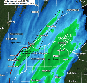
A gravity wave snow band has setup this evening just SE of Duluth, extending from the Bruno and Holyoke areas to Patzau and Oliver, northeast to Superior to along the North Shore from Larsmont to Two Harbors and all the way up the North Shore to just west of Lutsen, incredible! Snowfall rates of up to an inch or so per hour are possible underneath this snow band for a few more hours until conditions become less supportive for this gravity wave snow band. Note: This heavier band of snow may affect the far southeast/east sides of the city of Duluth until around Midnight while mostly light snow falls at the Airport.
Radar loop from 3:26 PM to 8:57 PM CT, Wednesday, December 23, 2020.
Source: https://weather.cod.edu/

- Blizzard conditions are expected to persist into the Overnight along the North Shore of Lake Superior where wind gusts of 50 to around 65 mph are expected. A wind gust of 71 mph was reported near the lake in Grand Marais this evening.
- Conditions although still very bad in Duluth are slowly improving as of mid Evening, although gusty winds will continue to cause areas of blowing and drifting snow and reduced visibility into Thursday morning, but additional snow that falls through the overnight should be on the light side with additional accumulations of around an inch. Road conditions will remain very hazardous if not treacherous through the night and probably into Thursday morning as well, avoid travel if possible.
- Very cold temps overnight and Thursday with lows tonight ranging from the teens below to single digits above zero, while highs on Christmas Eve range from the single digits below to single digits above zero across the Northland. Wind chills overnight into Thursday morning will range from around 15 below to as low as 35 below zero!
Note: Snow totals will likely end up on the lower side in Duluth compared to what I was forecasting (8-12″) but the other impacts and timing of those impacts verified nicely. Overall this system moved through quickly, plus I think the amount of dry air associated with the approaching arctic air mass probably played a role on keeping precip/snow totals less than what was forecasted over some parts of the Northland including in Duluth. However, the sudden onset of high winds, falling temps and heavy snow made for very dangerous conditions for about 1-3 hours in the Twin Ports late this afternoon-early this evening with blizzard conditions at times.
Snowfall Reports from around the Northland for December 23, 2020 (as of 8 PM)
Source: https://www.weather.gov/dlh/
- 6 SE Oliver, WI: 8.0″
- 4 SSE Herbster, WI: 8.0″
- Sarona, WI: 7.0″
- Buyck, MN: 6.8″
- 3 N Amnicon Falls S.P. 5.8″
- 2 SW Two Harbors, MN: 5.0″
- 9 WNW Hovland, MN: 5.0″ (storm total of 8″ since last night)
- 3 NE Duluth, MN: 5.0″
- 2 W Hayard, WI: 4.8″
- 7 NW Two Harbors, MN: 4.7″
- Gile, WI: 4.0″
- 2 NNW Mellen, WI: 3.8″
- 5 N Hayward, WI: 3.5″
A strong area of low pressure (989mb) was near the Wisconsin-Upper Michigan border as of 8 PM. This low will continue on its northeast track through the night.

Tim
Leave a Reply