- A cool night ahead as lows fall into the single digits and teens across the Northland, and then on Friday will see our highs warm into the upper 20s to middle 30s, with a few upper 30s possible around the Brainerd Lakes area.
- Saturday looks like one of our warmest days will see around here for a while as highs climb into the 50s in much of the Northland, and even areas near Lake Superior should cash in on this warmth thanks to an off-shore wind direction on Saturday. About the only thing that may keep temps from getting into the 50s would be the swath of snow that fell in parts of north-central and northeast Minnesota on Wednesday, so will have to wait and see if that snow pack plays a role in keeping temps a few degrees cooler on Saturday.
- A gusty east wind returns for Sunday and Monday which will lead to much cooler temperatures returning to areas near Lake Superior with highs around the freezing mark.
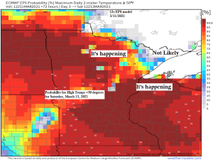
March 2021 thru the 11th has already featured 6 days with a high of at least 40 degrees (average for March is 8 days) in Duluth, and 2 days with a high of at least 50 degrees (average for March is 2 days)
March 2021 is running +9.6 degrees warmer than normal in Duluth (thru the 10th)
Snow early next week???
There is a lot of model disagreement showing up for early next week, with the GEFS ensemble model keeping this next system south of the Northland, with only 2 out of 20 members showing snowfall of 2″ or more reaching into northeast Minnesota and northwest Wisconsin early next week, all the other members keep the bulk of the snow farther south and out of our area per the 12z run from this morning.

And then we have the Euro ensemble model which is much more aggressive in shoving the snow associated with a Plains low much farther north and into northeast Minnesota and northwest Wisconsin for next Monday and Tuesday. Also of note is the UK model which is in strong agreement in showing a snowier solution for much of the Northland early next week.
Stay tuned!
One thing we will see late this weekend and early next week is strong high pressure north of our area, and a gusty and dry flow of air out of the NE will likely setup in the Northland, and often times with a setup like that, precipitation really struggles to make it this far north, so I’m surprised to see the Euro and UK models showing so much precip/snowfall in our area early next week.


Tim
Leave a Reply