A strong winter/spring storm hit the Northland Wednesday afternoon into Thursday morning bringing widespread heavy rain and snow to much of northeast Minnesota and northwest Wisconsin. Precipitation totals of 1 to nearly 3 inches were reported from east-central and northeast Minnesota into northwest Wisconsin, making this one of the biggest precipitation events we’ve seen in the Northland in months! Note: Duluth picked up 0.97″ of precipitation on March 10th, 2021, making it the greatest precipitation event in Duluth since November 9th, 2020 when 1.18″ of precipitation fell.
An estimated 9,000 Minnesota Power customers were without power Wednesday evening into early Thursday morning as widespread power outages occurred due to the combination of heavy wet snow and strong winds.
Note: About the only thing I was surprised about with last night’s storm was that we didn’t get any thundersnow in parts of northeast Minnesota, including in the Twin Ports, I really thought we would’ve had some of that given this storm’s dynamics, but it didn’t happen.
…Record 24-Hour Precipitation Total broken at Duluth, Minnesota for March 10th…
New record: 0.97″; old record was 0.56″ set 143 years ago in 1878.
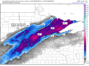
Snowfall Reports from March 10-11, 2021
Source: https://www.weather.gov/dlh/
- 3 WNW Embarrass, MN: 11.0″
- 3.7 NE Sea Gull Lake, MN: 11.0″
- Babbitt, MN: 10.0″
- 0.4 WSW Chisholm, MN: 9.3″
- Leader, MN: 9.2″
- 4 ESE Wales, MN: 9.0″
- Winton, MN: 8.5″
- Mckinley, MN: 8.0″
- 6 N Knife River, MN: 8.0″
- 7 NNW Two Harbors, MN: 7.5″
- 1 SSW Ely, MN: 7.5″
- Cohasset, MN: 7.3″
- Duluth Airport: 7.1″
- Nashwauk, MN: 6.5″
- 7 N McGregor, MN: 6.3″
- Wolf Ridge, MN: 6.0″
- West Duluth, MN: 6.0″
- 5.1 N Floodwood, MN: 6.0″
- 5.7 ESE Cotton, MN: 5.6″
- Hoyt Lakes, MN: 5.5″
- 2 SW Two Harbors, MN: 5.2″
- Cass Lake, MN: 5.0″
- 12 N Grand Rapids, MN: 4.5″
- 2 W Lester Park, MN: 4.3″
- 3.4 ENE Cloquet, MN: 4.0″
- Brainerd, MN: 4.0″
- Cotton, MN: 4.0″
- Two Harbors, MN: 4.0″
- 3 S Northome, MN: 4.0″
- Wrenshall, MN: 3.8″
- 8 NE Cook, MN: 3.5″
- 3 E Wright, MN: 3.5″
- 2.0 WNW Superior, WI: 3.5″
- 4.4 WSW Grand Marais, MN: 2.4″
- Kettle River, MN: 2.2″
- Oulu, WI: 2.0″
- 6 SW Finlayson, MN: 2.0″
- 9 N Bayfield, WI: 1.5″
- 4 W Clam Lake, WI: 1.0″
- Kabetogama, MN: 1.0″
- 3 S Ashland, WI: 1.0″
- 1.2 W Solon Springs, WI: 0.6″
Precipitation Reports from March 10-11, 2021
Source: https://www.weather.gov/dlh/
- Barnes, WI: 2.93″
- 10.6 WNW Spooner, WI: 1.93″
- 3.4 ENE Cloquet, MN: 1.87″
- 1.2 W Solon Springs, WI: 1.82″
- 3.2 NE Duluth, MN: 1.80″
- Minong, WI: 1.65″
- 4 W Clam Lake, WI: 1.38″
- Hurley, WI: 1.30″
- Glidden, WI: 1.27″
- Two Harbors, MN: 1.24″
- 2.0 WNW Superior, WI: 1.24″
- Ashland, WI: 1.19″
- Duluth Airport: 1.16″
- Hayward, WI: 1.14″
- Babbitt, MN: 1.07″
- Breezy Point, MN: 1.05″
- Danbury, WI: 1.03″
- Brainerd, MN: 1.00″
Wind Reports from March 10-11, 2021
Source: https://www.weather.gov/dlh/
- Duluth Airport: 55 mph
- Duluth Harbor: 51 mph
- Blatnik Bridge: 47 mph
- Ashland: 44 mph
- Brainerd: 41 mph
- Duluth Sky Harbor Airport: 41 mph
- Cloquet: 39 mph
- Washburn: 38 mph
- Bayfield: 37 mph
- Minong: 36 mph
- Hayward: 36 mph
- Saginaw: 34 mph
- Solon Springs: 33 mph
- Superior Airport: 32 mph
- Grand Rapids: 32 mph
- Chisholm-Hibbing Airport: 32 mph
- Moose Lake: 30 mph


A very cool satellite image from earlier this afternoon which shows what areas were impacted by a swath of accumulating snow on Wednesday (green areas) while areas in blue have no snow on the ground. Clouds show up in the whiteish/pinkish colors on the image below.

The 2021 Severe Weather Season in Minnesota kicked off on Wednesday, March 10th, with a total of 8 severe weather reports across southeastern Minnesota. All of those reports came in the form of large hail, ranging from 1 inch in diameter (quarter sized) to as large as 2.50″ in diameter (tennis ball sized)

Tim
Leave a Reply