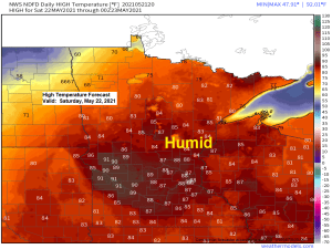
- Warm and muggy weather will continue in the Northland tonight and Saturday, with highs on Saturday in the 70s and 80s while dew points range from around 57 to 65 degrees.
- Areas of fog (possibly dense) will be found closer to Lake Superior tonight into Saturday morning, and chances for fog will return Sunday and Monday.
- Strong NE winds will develop near Lake Superior on Sunday with wind gusts of 20 to 35 mph.
- Much colder temperatures will be found in our area on Sunday with highs only in the 30s and 40s near Lake Superior and in the 50s well inland from Lake Superior.
Scattered showers and thunderstorms are possible across north-central and northeastern Minnesota late Saturday afternoon into Saturday night with a lesser chance for showers and thunderstorms in eastern Minnesota and northwest Wisconsin. A few showers could linger in our area on Sunday. The chances for rain this weekend will be caused by a cold front which will move SE across the Northland Saturday afternoon/night, this front will then stall out well to our south on Sunday.
An isolated strong to severe thunderstorm is possible across northern Minnesota (dark green area on map) Saturday evening. Hazards from those storms would be from downpours and lightning, with a chance for some hail in the strongest storms that may develop.
Note: A widespread severe weather outbreak is not expected on Saturday.

Here’s a look at two computer model radar simulations as to how things could play out Saturday and Saturday night.
First model is the NAM 3km which doesn’t show a whole lot of activity in the Northland Saturday or Saturday night.
Note: Forecast loop on both models runs from 7 AM Saturday to 1 PM Sunday.

The HRRR model is quite a bit more aggressive in terms of the coverage of showers and thunderstorms in the Northland late Saturday afternoon through Sunday morning.

Here’s a look at how much rain could fall in northeast Minnesota and northwest Wisconsin thru Sunday evening.

Even with the rain that we saw the last few days, rainfall totals for the month of May continue to run well below normal across the Northland – See stats below.
…Rainfall Departures for May 2021 – Thru 4 PM on the 21st…
Brainerd, MN: -1.88″ below normal
Duluth, MN: -1.59″ below normal
International Falls, MN: -1.31″ below normal
Hibbing, MN: -1.07″ below normal
Ashland, WI: -1.03″ below normal
…Record Warm Low Temperatures tied or broken in the Northland on May 20th, 2021…
Ashland, WI:
New Record: 66 degrees; old record 65 degrees set on May 20th, 1948.
Duluth, MN:
New Record: 61 degrees; old record 60 degrees set on May 20th, 1994.
International Falls, MN:
New Record: 61 degrees; old record 59 degrees set on May 20th, 1992.
Brainerd, MN:
Low of 65 degrees ties the record warm low temperature for May 20th, this record was set in 1948.
Hibbing, MN:
Low of 62 degrees ties the record warm low temperature for May 20th, this record was set in 1948.
Tim
Leave a Reply