Who needs warm air near the surface for storms? We certainly don’t need that near Lake Superior. A perfect example of that was from this morning when we saw a line of scattered strong to severe thunderstorms impact portions of the Northland including Duluth and Superior with reports of quarter size hail in Superior, along with frequent lightning and some heavy rain. These same storms dropped up to half dollar size hail around the Saginaw area around mid-morning today.
Radar loop showing the strong to severe storms which moved through the Twin Ports around 9-10 this morning.
Loop below runs from 8:47 AM to 4:32 PM, Friday, June 11, 2021.

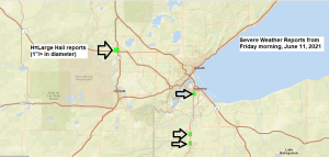
Local Storm Reports from around the Northland for June 10-11, 2021
Source: https://www.weather.gov/dlh/
- 9:55 AM (6/11) Hail 1.00″. 6 SE Oliver, WI (Douglas County) Quarter sized hail.
- 9:50 AM (6/11) Hail 1.00″. 6 NE Patzau, WI (Douglas County) Quarter sized hail.
- 9:50 AM (6/11) Hail 1.00″ 2 SW Saginaw, MN (St. Louis County) Quarter sized hail reported on Highway 2 just west of Highway 33.
- 9:47 AM (6/11) Hail 1.00″. 1 SW Superior, WI (Douglas County) Quarter sized hail.
- 9:46 AM (6/11) Hail 1.25″. 1 WSW Saginaw, MN (St. Louis County) Half dollar sized hail.
- 9:44 AM (6/11) Hail 1.00″. 1 SW Saginaw, MN (St. Louis County) Quarter sized hail.
- 9:15 PM (6/10) Hail 0.75″. 2 SSE Couderay, WI (Sawyer County)
- 8:55 PM (6/10) Hail 1.25″. 3 SE Northwoods Beach, WI (Sawyer County) Half dollar sized hail.
- 8:20 PM (6/10) Hail 1.00″. 3 NNE Little Round Lake, WI (Sawyer County) Quarter sized hail.
- 8:18 PM (6/10) Hail 1.75″. Hayward, WI (Sawyer County) Golf Ball sized hail reported 6 miles east of Hayward at the Intersection of B & K.
- 8:08 PM (6/10) Hail 0.70″. Hayward, WI (Sawyer County)
- 7:37 PM (6/10) Hail 0.70″. 6 W Seeley, WI (Sawyer County)
- 7:20 PM (6/10) Hail 1.50″. 2 WNW Seeley, WI (Sawyer County) Ping pong ball sized hail.
- 6:11 PM (6/10) Hail 1.50″. Butternut, WI (Ashland County) Ping pong ball sized hail.
24 Hour Rainfall Reports from around the Northland ending at 4 PM Friday, June 11, 2021
Source: https://mesowest.utah.edu/
- Glidden, WI: 1.08″
- Cloquet, MN: 0.55″
- Superior Airport: 0.42″
- Clam Lake, WI: 0.26″
- Duluth Airport: 0.24″
- Washburn, WI: 0.18″
- Skibo, MN: 0.16″
- Isabella, MN: 0.10″
- Hayward, WI: 0.10″
- Ashland, WI: 0.08″
- Ely, MN: 0.04″
- Chisholm-Hibbing Airport: 0.03″
Parts of northern/northeast Wisconsin saw quite a bit of rain and even some flooding on Thursday with rainfall totals of 1 to nearly 4 inches.

Thursday was a fairly active day for severe weather, with the Dakotas hit especially hard by widespread severe storms producing damaging winds during the late afternoon and overnight hours.


As lousy or nice (depending on how you look at it) as today’s weather was near Lake Superior, Saturday looks 100 times better as will get a wind shift to the west, this combined with a lot of sunshine should lead to daytime highs topping out around 80-83 degrees near Lake Superior on Saturday.
Much warmer away from Lake Superior today with highs in the mid 70s to mid 80s with even a few upper 80s at Siren and Hayward in northwest Wisconsin. Highs this weekend will remain in the 70s and 80s but with much lower humidity levels.

Generally speaking we’re looking at another stretch of warm temperatures in Duluth through next week, although it does look like will get a wind shift Sunday afternoon as an east wind develops, so once that occurs temperatures will drop from the 80s to around 60 sometime Sunday afternoon within about 10-15 miles of Lake Superior.
7 days at or above 80 in Duluth so far this month, normal in June is 5 days, record is 17 days at or above 80 set in June 1910.
Note: Normal highs in Duluth from June 12 to June 21 range from 71 to 74 degrees, with normal lows ranging from 49 to 52 degrees.

A few strong to severe thunderstorms remain possible this evening over portions of northwest Wisconsin, while a few showers and possibly a thunderstorm or two is possible in northern Minnesota and the Arrowhead mainly before Midnight tonight.

A nice looking area of low pressure moving ENE across southern Manitoba province this afternoon. This area of low pressure will lift NNE tonight, and this system will help produce a fairly breezy day in the Northland on Saturday as westerly winds gust to around 20-25 mph.

A closer look at today’s strong low pressure system over southern Manitoba province per water vapor imagery.

A quick moving system moving SE across the area on Sunday could bring a few showers to the Northland, but right now this doesn’t look like a big deal as moisture will be lacking for this system, plus instability looks pretty minimal at the moment so thunderstorm development isn’t expected, but should the amount of moisture and instability trend higher, then we could see a few strong storms develop on Sunday since winds aloft look to be on the strong side.
18z NAM 3km model simulated radar forecast valid from 7 AM Sunday to 10 PM Sunday.

Tim
Leave a Reply