A few strong to severe thunderstorms remain possible across northeast Minnesota and northwest Wisconsin tonight as a cold front moves through the area. Storms are expected to develop this evening in far northern Minnesota with storms moving east or east-southeast overnight. Note: Timing for when we could get some thunderstorms in Duluth and Superior is from around 1 AM to 4 AM tonight.
The main hazards from thunderstorms that may become severe tonight across northern Minnesota is from damaging wind gusts to 60 mph and large hail to 1″ in diameter (Quarter size)
Note: Additional thunderstorms could also develop late tonight over parts of east-central Minnesota and northwest Wisconsin in a warm air advection regime, these areas could have higher amounts of instability (elevated CAPE) by late tonight with values possibly >2000 J/kg, this combined with favorable wind shear, a SW low level jet increasing to 30-45 knots and stronger mid/upper level winds could lead to a few supercells capable of producing large hail up to Ping Pong Ball size (1.25″) and wind gusts to 60 mph late tonight/early Thursday morning.
Stay Weather Aware Tonight!
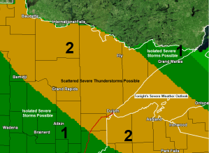
There is a Slight Risk (yellow) and Marginal Risk (dark green) for Severe Thunderstorms in the Northland tonight.


One limiting factor for convection tonight is the marginal amounts of low level moisture as dew points are only in the 50s across the Northland this afternoon, but dew point temperatures might climb a few more degrees tonight, possibly reaching the 60-63 degree range before a drier air mass returns from NW-SE on Thursday behind tonight’s cold frontal passage.

Greatest instability (outlined in yellow) is off to our SW this afternoon but some of that is forecast to push NE into at least southern portions of the Northland by late tonight. Meanwhile across northern Minnesota instability will be weaker (outlined in black) but still sufficient for the potential of strong to severe thunderstorms tonight.

Here comes our source of lift tonight in the form of a trough and cold front which is approaching from the NW late this afternoon.
Note: Greatest lift shows up as orange, red and purple colors on the map below – We should see some storms fire up near the maximum lift areas before 7 PM tonight.

Here’s a look at two computer model simulated radar forecasts valid thru 7 AM Thursday – Both models generate scattered storms tonight, but differ a little bit on what areas get hit which is pretty typical.
18z NAM 3km model

18z HRRR model.

Tonight’s thunderstorm activity will likely be isolated to scattered in coverage in the Northland which means that some areas get hit, others get missed — Aerial average rainfall amounts of 0.10″ to around 0.50″ are possible tonight, but higher amounts >1″ are possible as precipitable water increases to ~1.25″ to 1.80″ tonight.

Thunderstorms that develop tonight into early Thursday morning could be prolific lightning producers as they track east or southeast across northeast Minnesota and northwest Wisconsin.

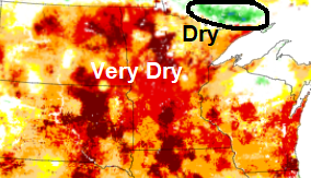
The 0-100 cm Soil Moisture map as of June 23rd, 2021 shows that all of northeast Minnesota and northwest Wisconsin is on the dry side, with very dry soils in the red and darker red areas (<10% soil moisture) Note: The green area (outlined in black) represents moist soils.
Fire Danger ranges from High (yellow) to Very High (orange) across parts of northeast Minnesota today, with Extreme fire danger in the red areas.

A very wet pattern is expected to develop over the next several days over parts of the Midwest into the Central/Eastern Great Lakes, while below normal precipitation is expected thru the end of the month across northeast Minnesota and most of northwest Wisconsin.

Big time rain totals and flooding is possible over the next several days well south/east of the Northland.

A warm late June day across northeast Minnesota and northwest Wisconsin with temperatures this Wednesday afternoon in the 80s.
Note: Duluth recorded its 12th day this month at or above 80 today, and will probably add another 80 degree day on Thursday. The record for most number of 80 degree days in June is 17 set in 1910, and it still looks like will fall a few days short of this record based on model forecasts.

Tim
Leave a Reply