…Local Storm Reports from Sunday, June 27, 2021…
Source: https://www.weather.gov/dlh/
- 6:18 PM: Flood – 1 mile east-northeast of West Duluth, MN (St. Louis County) Localized intersection flooding in West Duluth. Water up to axles of some vehicles.
- 6:26 PM: Hail 0.25 inch – 1 mile west of Superior, WI (Douglas County)
- 6:29 PM: Hail 0.25 inch – Superior, WI (Douglas County)
- 6:30 PM: Hail 0.25 inch – 1 mile southwest of Superior, WI (Douglas County)
- 7:23 PM: Heavy Rain. 1.25″. Superior, WI (Douglas County) Fell over 45 minutes to an hour between 6 and 7 PM.
- 7:34 PM: Hail 0.25 inch – 3 miles south-southeast of Bovey, MN (Itasca County) Pea-sized hail for about 5 minutes.
Very little change in our weather is expected for Monday and Tuesday with more chances for scattered showers and thunderstorms across the Northland with the best chance for thunderstorms coming during the afternoon and early evening when instability will be at its peak. Still not looking at any threat for severe weather, however, since there is very little wind shear to speak of, this combined with poor mid level lapse rates will likely keep these storms below severe criteria, but a few instances of small hail and or gusty winds are possible in the strongest storms Monday and Tuesday, and like we saw today, torrential rainfall will also occur in spots since there is a decent amount of moisture in the atmosphere, while very weak low/mid level winds result in very slow moving storms.
Radar simulated forecasts valid from 7 AM Monday to 7 PM Monday.
18z NAM 3km model

18z HRRR model

Rainfall totals will continue to vary considerably in short distances throughout the Northland over the next few days. On average we’re looking at about a tenth to half an inch of rain in much of the Northland through Tuesday evening, but there will be localized higher amounts of over an inch.

A small cluster of strong thunderstorms blew up in a span of about 20 minutes right over portions of the Twin Ports late this Sunday afternoon – These storms produced torrential downpours, cloud to ground lightning and some gusty winds.
Here are a few radar grabs from late Sunday afternoon showing how quickly these thunderstorms developed over Duluth and Superior.


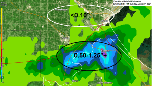
Check out these one hour rainfall estimates from late Sunday afternoon, June 27, 2021 – Ranging from over an inch from the southern portions of Duluth through the city of Superior, while rainfall totals of generally <0.10″ were found across the northern portions of Duluth.
Note: The distance from Superior Airport to Duluth Airport is about 16 miles, and wow what a range in rainfall totals in that short distance! About an inch difference in rainfall amounts today!

…24 Hour Rainfall Reports through 7 PM Sunday, June 27, 2021…
Source: https://mesowest.utah.edu/
- Superior Airport: 1.18″
- Littlefork, MN: 0.94″
- Brainerd, MN: 0.61″
- Bigfork, MN: 0.56″
- Hill City, MN: 0.46″
- Cloquet, MN: 0.40″
- Minong, WI: 0.40″
- Isabella, MN: 0.31″
- Aitkin, MN: 0.28″
- Two Harbors, MN: 0.25″
- International Falls, MN: 0.21″
- Duluth Airport: 0.17″
- Solon Springs, WI: 0.17″
- Siren, WI: 0.17″
- Moose Lake, MN: 0.12″
- McGregor, MN: 0.11″
- Walker, MN: 0.11″
- Grand Marais, MN: 0.09″
- Hayward, WI: 0.08″
- Ashland, WI: 0.05″
- Chisholm-Hibbing Airport: 0.05″
- Clam Lake, WI: 0.04″
- Washburn, WI: 0.04″
- Ely, MN: 0.02″
Goes-16 water vapor loop from Sunday, June 27, 2021 showing a monster ridge poking well north into northwest Canada today with troughing downstream of that ridge across the upper Midwest and Great Lakes.

90s and even near 100 degree temps this afternoon well north into western Canada, with widespread 100s in Washington and Oregon, big time heat wave!

High Temperature Forecast valid from Monday, June 28, 2021 through Sunday, July 4, 2021.
Looking at highs in the middle 70s to middle 80s in northeast Minnesota and northwest Wisconsin Monday, Tuesday and Wednesday, this will be followed by a cooler Thursday, especially near Lake Superior (highs in the 60s) After that it looks like will be warming up again in the Northland for the Fourth of July holiday weekend as highs could reach well into the 80s, and maybe even up close to 90 next weekend.

Tim
Leave a Reply