A big drop in temperatures is coming on Tuesday – Check out the temperature forecast from the 18z NAM 3km model valid from Midnight tonight to 7 PM Tuesday. Overnight temps in the 60s to lower 70s tonight, and then will see falling temperatures during the day Tuesday, in fact by Tuesday afternoon we could have temperatures only in the upper 40s to upper 50s in much of eastern Minnesota and northwest Wisconsin, and there will also be a gusty NE wind near Lake Superior with wind gusts to 25 mph. Note: It’s possible we could see temps low enough where we are able to calculate a wind chill (feels like temp) near Lake Superior come Tuesday afternoon, how’s that for some weather whiplash?

A rather organized low pressure system over the Northern Rockies today will move east and will affect the upper Midwest’s weather on Tuesday – This system should bring a decent amount of lift with it resulting in a widespread light to moderate rainfall event for much of northeast Minnesota and northwest Wisconsin on Tuesday.
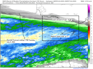
Rainfall totals with Tuesday’s system look to range from a half inch to an inch across southern portions of the Northland, while areas farther north see a lot less rain, with totals ranging from a trace to less than a quarter inch for International Falls, Crane Lake, Ely and Grand Marais.
Note: So far in 2021, Duluth is running -4.14″ below normal in precipitation, but if you go all the way back to 2020 and include the precipitation deficit from then through July 4th, 2021 reveals that Duluth is ~14″ below normal in precipitation, we’re certainly seeing a longer term dryness/drought event locally, and it’s going to take time to erase the longer term deficit. The problem we’ve been having is that we’ve been getting into long stretches, 2 weeks or more between significant rain events (0.50″+) That type of pattern has to stop, because it really isn’t doing any good if we get a good soaking rain (0.50-1″) if we just go right back into a dry spell that lasts 14 days or longer until our next significant rain event.
Goes-16 water vapor loop from Monday, July 5, 2021 showing our system for Tuesday currently moving across the Rockies and Northern Plains today.

There is some disagreement in computer models on the start and end times to the rain in Duluth and Superior, but at the moment it looks like the rain will begin in the Twin Ports between 4-7 AM Tuesday, and will end between 4-7 PM Tuesday.
Tuesday’s system looks very similar to a system which impacted our area back on June 20th, that one produced an all day rain with over an inch of rain in Duluth.
Here’s a look at the 18z NAM 3km model simulated radar forecast valid from 1 AM tonight to 7 PM Tuesday.
Note: A few thunderstorms are possible Tuesday across northwest Wisconsin and eastern Minnesota where some elevated instability will be present, but severe weather is not expected in our area on Tuesday.

…Record Warmth in the Northland over the Fourth of July weekend 2021…
Record Highs broken or tied on July 3rd
International Falls, MN: Tied the record high of 92 which was last set in 2020.
Record Highs broken on July 4th
International Falls, MN: New record high of 93; old record was 90 set in 2020
Hibbing, MN: New record high of 91; old record was 90 set in 1988
Note: Yes it was a warm weekend in Duluth, but no new high temperature records were set, and in fact the heat wave we saw back in early June was hotter compared to the one we had over the 4th of July weekend – See stats below.
High temps from the June 2021 heat wave in Duluth
6/4: *94 (record high for the date)
6/5: *94 (record high for the date)
6/6: 87
High temps from the July 2021 heat wave in Duluth
7/3: 87
7/4: 92
7/5: 90
We’ve had 4 days at or above 90 so far this year in Duluth, Minnesota (average for an entire year is just 2 days) The record for most 90 degree days in a year is 14 days set in 1936.
High temperature forecast valid from Wednesday, July 7, 2021 through Sunday, July 11, 2021.
Coolest days of the week in the Northland look to be Tuesday and Wednesday, after that temperatures climb a bit once again, reaching the 70s and maybe even some 80s this weekend.

Rainfall reports from Sunday, July 4, 2021
- Embarrass, MN: 0.25″
- Floodwood, MN: 0.22″
- Two Harbors, MN: 0.21″
- 7.7 W Spooner, WI: 0.20″
- 25 E Ely, MN: 0.18″
- 2 S Tower, MN: 0.07″
- 3 E Wright, MN: 0.04″
- 3 E Orr, MN: 0.04″
- Cook, MN: 0.01″
We’ve had some fantastic sunrises in Duluth the last few days due to wildfire smoke which has been moving south out of Ontario Canada, while we’ve also had some mid/high level cloudiness drift overhead right around sunrise which adds even more color to the sky!
July 4, 2021 – Sunrise over Lake Superior – Park Point, Duluth, Minnesota.


July 5, 2021 – Sunrise over Lake Superior – Park Point, Duluth, Minnesota.


Tim
Leave a Reply