3:30 PM Friday, 8/20/2021
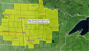
A severe thunderstorm watch has been issued for northern Minnesota and eastern North Dakota until 10 PM this evening. For the Northland this watch includes the counties of Koochiching, Itasca, Cass and Crow Wing, and the cities of International Falls, Bigfork, Grand Rapids, Cass Lake, Walker and Brainerd.
Primary threats include
Scattered damaging wind gusts to 70 mph possible
Scattered large hail events to 1.5 inches in diameter possible
A tornado or two possible
Remember a severe thunderstorm watch means conditions are favorable for severe thunderstorms in and close to the watch area. Persons in these areas should be on the lookout for threatening weather conditions and listen for later statements and possible warnings. Severe thunderstorms can and occasionally do produce tornadoes.
The atmosphere is fairly unstable over western Minnesota this afternoon with CAPE of ~2000 J/kg, but those values drop off quickly farther east over the Northland, but we should see higher CAPE (more instability) build ENE into at least western/southern portions of the Northland through this evening thanks in part to a strengthening low level jet out of the south.
Winds aloft are on the strong side and we’re also seeing winds veering with height…S-SE winds near the surface to 850mb, then SW at 500mb — This combined with around 30 knots of 0-6 KM shear is enough to produce a few severe thunderstorms and perhaps even a few supercell thunderstorms through this evening, mainly over parts of northwest, north-central, into west-central Minnesota.

MRMS radar loop ending at 3:30 PM Friday, August 20, 2021.
Lines of showers and thunderstorms (occasionally severe) are lifting north/northeast across the eastern Dakotas and western Minnesota as of mid-afternoon Friday. Will continue to see this activity move north-northeast through tonight, with some rain eventually reaching northeast Minnesota and northwest Wisconsin including Duluth and Superior and the Greenwood fire area especially after Midnight tonight.

Tim
Leave a Reply