1 PM Friday 8/20/2021
It still looks like will get at least a little bit of rain in the Northland later today, but more so tonight-early Saturday morning, but amounts look pretty light, except in western portions of the area, roughly along and west of a line from International Falls to Hinckley — That area could see upwards of a half inch or so of rain out of this system, while the rest of us may see as little as a trace to around a quarter inch of rain.
Surface map early this Friday afternoon had an area of low pressure over central North Dakota with a cold front extending south from that low. This system will lift NE through Saturday morning, while the surface low deepens from ~1002mb this afternoon to ~990mb by Saturday morning. Large scale lift will accompany this system and its upper level trough, and this will lead to widespread rain and thunderstorms through tonight across the Northern Plains and upper Midwest, but as the rain moves into northeast Minnesota and northwest Wisconsin it will likely diminish in coverage and intensity late tonight as the best forcing pulls into Canada.

HREF model rainfall forecast through Saturday morning

Unfortunately it doesn’t look like there’s going to be much rain falling over the Greenwood fire area in western Lake County tonight, with rainfall amounts ranging from a trace to a quarter of an inch.
Rainfall forecast through Saturday morning using a blended model approach

Computer model simulated radar forecasts show similar outcomes for this event — Heavier rain and thunderstorms impacting northwest, west-central and north-central Minnesota through this evening, then this activity weakens to scattered showers and isolated thunderstorms as it reaches northeast Minnesota and northwest Wisconsin late tonight/early Saturday morning.
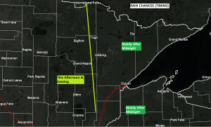
Note: Best chance for some rain in Duluth and Superior won’t be until late tonight, mostly around or after Midnight.
12z NAM 3km model

12z HRRR model
Note: Best chance for a few severe thunderstorms this afternoon and evening will be in that magenta outlined area on the map. Damaging winds and isolated tornadoes are the main severe weather threats through this evening with large hail a lesser concern.

Tim
Leave a Reply