Greenwood Fire information as of 4:30 PM Saturday, August 21, 2021
Size: 9,067 acres
0% contained
Total Personnel: 321
The entire BWCA will be shutting down due to rapid wildfire growth and drought conditions – This closure will continue for 7 days, and will be re-evaluated on a weekly basis
Day trips to the BWCA are not allowed under the closure.
This includes all entry points on the Gunflint Trail, Sawbill Trail, Arrowhead Trail and across the Gunflint and Tofte districts.
Also included in the closure are all portages, lakes, waterways and hiking trails in the BWCA.
Northwest winds will continue tonight causing the fire to spread farther east. Winds become southeast on Sunday which could cause the fire to spread back toward the west and northwest, and then on Monday winds are forecast to shift out of the southwest which may cause the fire to spread farther northeast.
Winds speeds will range from 5 to 15 mph tonight through Monday, with gusts to 20-25 mph possible Sunday and Monday afternoons.

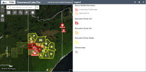
Greenwood Lake Fire Evacuation zone.
Note: Lake County Sherriff’s Office is alerting everyone in the potential path of the Greenwood Fire that they may need to evacuate, this includes portions of Fall Lake Township.

John Elk fire has grown to 2,000 acres as of 7 PM Saturday, August 21, 2021 with 0% containment.
Whelp fire has grown to 20 acres as of 4 PM Saturday, August 21, 2021 with 0% containment.

It’s been difficult to pick out the Greenwood fire on satellite imagery today due to all the clouds which have been moving through the area, but one fire that does stand out is a new one which has started at the tip of Isle Royale (outlined in yellow)
Goes-16 visible satellite loop from Saturday, August 21, 2021

A few fast moving showers are possible over the Northland including over the Greenwood Fire Sunday night, but widespread significant rains are not expected Sunday night.
18z NAM 3km model simulated radar forecast valid from 7 PM Sunday to 7 AM Monday.

Rainfall forecast thru 7 AM Monday — A trace to <0.10″ rain totals for northeast Minnesota and northwest Wisconsin Sunday night.

Tim
Leave a Reply