Rainfall Totals from Sunday night/Monday morning, August 22-23, 2021
Orr, MN: 0.14″
Littlefork, MN: 0.08″
Moose Lake, MN: 0.07″
Chisholm-Hibbing Airport: 0.04″
International Falls, MN: 0.03″
Effie/Bigfork, MN: 0.03″
Grand Rapids, MN: 0.03″
Isabella, MN: 0.02″
Duluth Airport: 0.01″
Grand Marais, MN: 0.01″
Rainfall totals and deficits from around the Northland
Duluth, Minnesota
Month to date: 0.60″; -2.03″ below normal
Since June 1, 2021: 5.14″; -5.80″ below normal
Since January 1, 2021: 13.71″; -6.55″ below normal
International Falls, Minnesota
Month to date: 0.80″; -1.17″ below normal
Since June 1, 2021: 3.86″; -5.86″ below normal
Since January 1, 2021: 9.16″; -7.76″ below normal
Brainerd, Minnesota
Month to date: 1.68″; -0.53″ below normal
Hibbing, Minnesota
Month to date: 0.59″; -1.56″ below normal
Ashland, Wisconsin
Month to date: 0.27″; -2.25″ below normal
Rain chances Tuesday
There is another chance for some rain in northeast Minnesota and northwest Wisconsin on Tuesday, but computer models disagree on where the heaviest rain will setup, although the trend seems to be for the most significant rain to setup near and a little north of the I94 corridor in central Minnesota, meaning that most of the Northland would miss out on getting a good soaking rain on Tuesday.
Simulated radar forecasts valid from 1 AM tonight to 1 AM Wednesday.
12z NAM 3km model

12z HRRR model
Note: The HRRR model shows a better chance for heavier rain farther north compared to the 3km NAM model with Tuesday’s activity.

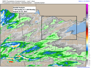
A look at forecast rainfall amounts for Tuesday’s system shows the potential for a half inch (maybe more) of rain in the black outlined area on map, while totals of up to a quarter of an inch are possible farther north including over the Greenwood fire.
Much of northeast Minnesota and northwest Wisconsin is running 1-2+” below normal in rainfall this month so will see if we can chip away at this deficit at least a little bit on Tuesday.

Tim
Leave a Reply