Northern Minnesota were the big winners with last night’s rainfall, while much of the Twin Ports and northwest Wisconsin missed out on getting a lot of rain last night.
I say much of the Twin Ports because the Airport (on top of the hill) did pick up over a quarter inch of rain (0.31″) last night, while Superior and the Duluth Harbor only picked up between 0.01″ to 0.05″ of rain.
Here are the 24 Hour Rainfall Reports from around the Northland.
Source: https://mesowest.utah.edu/
Totals listed below are thru 7 AM Sunday, October 10, 2021.
Eveleth-Virginia, MN: 2.15″
McGregor, MN: 1.89″
Brainerd, MN: 1.29″
Orr, MN: 1.17″
Aitkin, MN: 0.86″
Littlefork, MN: 0.83″
Walker, MN: 0.81″
Cotton, MN: 0.70″
Pine River, MN: 0.59″
Saginaw, MN: 0.54″
Cass Lake, MN: 0.53″
Chisholm-Hibbing Airport: 0.51″
Hill City, MN: 0.45″
International Falls, MN: 0.44″
Grand Rapids, MN: 0.43″
Bigfork, MN: 0.41″
Isabella, MN: 0.40″
Cloquet, MN: 0.34″
Cook, MN: 0.34″
Duluth Airport: 0.31″
Glidden, WI: 0.24″
Ely, MN: 0.18″
Clam Lake, WI: 0.16″
Grand Marais Airport: 0.13″
Moose Lake, MN: 0.09″
Two Harbors, MN: 0.06″
Superior Airport: 0.05″
Seagull Lake, MN: 0.03″
Hinckley, MN: 0.02″
Washburn, WI: 0.02″
Ashland, WI: 0.02″
Hayward, WI: 0.02″
Duluth Sky Harbor Airport: 0.01″
Solon Springs, WI: 0.01″
Minong, WI: 0.01″
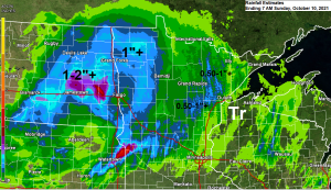
Here’s a zoomed in view of rainfall estimates across the Northland from last night. Highest amounts were off to the northwest, lowest amounts to the southeast, so that part of the forecast was spot on, but actual rain totals in the areas that saw the lowest amounts ended up being quite a bit less than what the forecast was calling for.

Will see more scattered showers along with a few thunderstorms in the Northland today, but most of this rain looks to remain over northern Minnesota into the Arrowhead, while rain chances are lower farther south including for Duluth, eastern Minnesota and northwest Wisconsin today.
11z/6 AM HRRR model simulated radar forecast ending 11 PM tonight.

With the surface and upper level low moving slowly ENE out of western Minnesota and over northern Minnesota today, this will help keep the chances for some convection going throughout the day, and with colder temps moving in aloft due to the upper level low moving over the area, we could see a few of the stronger storms that may develop produce hail to quarter size along with gusty winds, and there is even a chance for a tornado or two this afternoon, mainly in far northern Minnesota (yellow outlined area on map).

Tim
Leave a Reply