A strong fall storm will continue to impact the Northland tonight and Friday with accumulating snow across north-central Minnesota, and a mix of rain and snow elsewhere in the Northland. Precipitation rates will be heaviest tonight, with mostly light precipitation rates expected Friday.
Very strong ENE winds which impacted areas along the North Shore of Lake Superior last night and today will continue to diminish this evening.
- Winter Storm Warning remains in effect until Noon Friday including the cities of International Falls, Littlefork, Big Falls and Northome.
- Winter Weather Advisory remains in effect until Noon Friday including the cities of Cass Lake, Walker, Longville, Leader, Pine River, Bigfork, Togo, Effie, Crane Lake and Ely.
Plan on slippery road conditions in the warning and advisory areas. The hazardous conditions could impact the Friday morning commute.
Winter Storm Warning in pink
Winter Weather Advisory in purple

Here’s my final snowfall forecast (additional amounts) for this storm.
For Duluth and Superior: Little to no snow accumulation for lower elevation (below the hill), while on top of the hill snowfall amounts could reach an inch or two, with a half inch of snow reported at the Duluth Airport thru 4 PM today.

Road conditions have deteriorated in parts of northern Minnesota late this afternoon, and expect this trend to continue tonight into Friday morning as temperatures drop to the upper 20s to around 30 degrees while snow continues to fall and accumulate.
Roads are either completely covered or partially covered in parts of northern Minnesota as of 5 PM Thursday.

MNDOT Snow Plow Camera Images from late Thursday afternoon.
US 169 near Hibbing, MN (4:34 PM Thursday, November 11, 2021)

US 53 between Independence and Twig, MN (4:34 PM, Thursday, November 11, 2021)

Updated Precipitation Totals thru 5 PM Thursday, November 11th, 2021
Grand Portage, MN: 3.44″
The Bay of Grand Marais, MN: 3.29″
Isabella, MN: 1.88″
Washburn, WI: 1.47″
Duluth Airport: 1.43″
Skibo, MN: 1.32″
Chisholm-Hibbing Airport: 1.26″
Duluth Sky Harbor Airport: 1.16″
International Falls, MN: 1.14″
Seagull Lake, MN: 1.10″
Note: There was a report of flooding at 3:02 PM today, 7 miles west-southwest of Hovland, MN in Cook County, with a report of a culvert being washed out as well as some minor flooding nearby.
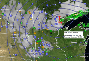
A strong area of low pressure of 987mb or 29.15″ was over northeast Minnesota, near Ely at 4 PM today. This low will begin to drop southward into east-central Minnesota tonight, reaching west-central Wisconsin Friday morning.

Widespread snow continues across northern Minnesota late this afternoon, with mostly rain in the Arrowhead and along the North Shore of Lake Superior. Precipitation is moving toward the west-northwest, and we’re seeing the effects of a dry slot pushing northward into parts of the Northland as precipitation is diminishing in northwest Wisconsin late this afternoon.
MRMS radar loop ending 4:50 PM, Thursday, November 11, 2021.
Snow in blue
Rain in green

-Widespread snow continues in north-central Minnesota tonight, while areas of light snow or mixed rain and snow continues in northeast and east-central Minnesota and northwest Wisconsin.
-Areas of light snow or mixed rain and snow continues in the Northland on Friday, while lake effect snow showers develop along the South Shore of Lake Superior in northwest Wisconsin.
Note: Snowfall rates in north-central Minnesota will be heaviest tonight, with mainly light snowfall expected on Friday.
18z NAM 3km model simulated radar forecast ending 6 AM Saturday.
Snow in blue
Rain in green

An additional 0.10″ to nearly 0.50″ of precipitation is expected in western-northern portions of the Northland thru late Friday afternoon, while an additional trace to 0.10″ of precipitation is possible in northwest Wisconsin and eastern Minnesota, precipitation totals in these areas will be lower due to the presence of a dry slot which rotates over these areas tonight.

Goes-16 water vapor loop from Thursday, November 11, 2021.
A powerful storm across the upper Midwest today, and a plume of moisture associated with this storm extended from the Gulf of Mexico to the Ohio Valley, northwest to Lake Superior to central Canada, then south to the Northern Plains.

Tim
Leave a Reply