5:08 PM Wednesday, January 19, 2022
A frigid air mass has moved into the upper Midwest today behind Tuesday’s clipper low, which was over Quebec late this afternoon, meanwhile we have a severe thunderstorm watch covering portions of east Texas, Louisiana southern Arkansas, and western Mississippi until 7 PM this evening, and to top it off, a winter storm warning covers parts of southern Texas (including Laredo, Victoria and Corpus Christi) for Thursday-early Friday.
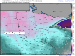
A strong arctic high (~1040mb/30.71″) over the Northern Plains will slowly move SE reaching southwest Minnesota around daybreak Thursday. Cold air advection will continue on the NE side of this high tonight, and this will lead to much colder temperatures tonight compared to what we saw last night. Low temperatures are forecast to range from around -15 to -30 degrees in the Northland tonight, and Thursday’s temperatures will remain in the freezer with highs ranging from around 5 below to 5 above zero.
Another frigid night is likely for Thursday night, but after that will see temperatures moderate a bit as arctic air pushes off to the east while we get a shot of warm air advection on Friday along with a little snow for Friday night, but a few more shots of cold arctic air may affect the Northland as we get into next week.

We have Winter Storm Warnings and Advisories in effect all the way down to central and south Texas for Thursday and Friday with some snow and ice expected in those areas.

A Wind Chill Advisory covers all of northeast Minnesota and northwest Wisconsin until Noon Thursday. Impacts — Wind chills as low as 35 below to 40 below zero.


Despite the cold temperatures over the last few weeks there really isn’t a whole lot of ice on Lake Superior as evidence by the widespread lake effect clouds which were moving SE across the lake today which means there is plenty of open water (source of warmth/moisture) to develop lake clouds and snow.

~7% of Lake Superior is covered by ice as of January 18, 2022. Average at this time of year is ~15%.

It looks like will get some snow in the Northland Friday evening into early Saturday morning as a low-pressure system pushes through the area. Snowfall amounts look to remain on the light side, however, with accumulations generally in the half inch to two-inch range the way it looks now.

Thanks for reading!
Tim
Leave a Reply