5:53 PM Tuesday, April 5, 2022
A strong and slow-moving spring storm will impact northeast Minnesota and northwest Wisconsin through early Friday.
This storm will bring wet snow, rain, a mix of rain and snow along with gusty winds to the Northland over the next few days.
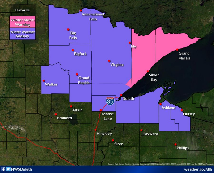
A Winter Storm Warning is in effect for the North Shore and Arrowhead of Minnesota through 7 AM Friday, while Winter Weather Advisories cover other parts of the Northland through Friday morning.
Brief whiteout conditions could develop later tonight through Wednesday morning along the North Shore of Lake Superior due to falling and blowing snow.
The potential does exist for there to be scattered power outages in parts of the Northland, especially along the North Shore due to the heavy wet snow sticking to trees and powerlines over the next few days.
Expect a mix bag of precipitation types across the Northland over the next few days with rain and snow being the primary precipitation types, but some patchy sleet can’t be ruled out especially tonight into Wednesday morning.
There will be some breaks in the precipitation in parts of the Northland especially on Wednesday as we see some effects of a dry slot move over the Northland.
Temperatures aloft are cold enough to support frozen precipitation for the duration of this storm, but boundary layer temperatures will be warmer and in that marginal range (31-36F) to where precipitation could fall as snow or rain.
For Duluth — Wet snow or a mix of rain, drizzle and snow this evening turning over to mostly snow overnight. Precipitation changes back over to rain, drizzle or a mix of rain/snow during the Wednesday through Wednesday evening before we see the precipitation switch back over to mostly snow during the day on Thursday.
Simulated radar forecast through 1 AM Friday.
Snow (blue)
Rain (green)

Here’s my updated snowfall accumulation forecast through Friday.
- This will be a wet, heavy, slushy type of snow.
- Some of the snow will likely melt on contact, especially on pavement unless snowfall rates are heavy enough to cool the pavement temperature.
- Greatest snowfall accumulations will likely be on grassy and elevated surfaces.
- This may end up being an elevation type of storm where snow totals are considerably higher inland from Lake Superior (10-20 miles from the lake) compared to locations closer to Lake Superior.
- The bulk of the snow accumulations across northwest Wisconsin will come Wednesday evening through Friday.
For Duluth — I’m going with 3-6″ of snow through Friday, but most of this should fall prior to Noon Wednesday since the heaviest precipitation/snowfall rates look to occur tonight through early Wednesday morning with lingering precipitation/snow at times likely from Wednesday afternoon through Friday, but it could be a case where it’s snowing but really not accumulating much past Wednesday morning. Also, snowfall amounts could end up lower below the hill tonight through Wednesday morning (perhaps more in that trace to 2″ range) with the higher snow totals found on top of the hill (higher elevation).

Widespread precipitation totals (water equivalent) ranging from a half inch to over an inch is likely across northeast Minnesota and northwest Wisconsin through Thursday evening, with even higher amounts possibly up to 2″ along the North Shore of Lake Superior.

Dual surface lows late today, one in far western Minnesota, the other moving into northwest North Dakota. These lows will more or less phase into one main surface low as it tracks east-southeast through Thursday.

A closed off mid-level low across the Northern Plains this afternoon will move very slowly to the ESE across the upper Midwest and Great Lakes through Friday morning.

A very active Pacific jet stream in place right now with at least four strong systems across the northern/eastern U.S. and also over the far north Atlantic.
Goes-16 water vapor loop from Tuesday, April 5, 2022.

Strong upper-level winds on the order of 120-140 knots to the SW of the Northern Plains low is adding energy to this system.

Wind will be an issue across the Northland for the next few days.
Wind gusts of 25 to 40 mph are likely tonight through Friday, with even stronger wind gusts possible near Lake Superior (North Shore) tonight through Wednesday morning.
Winds will generally be out of the east tonight, then out of the south, east or north on Wednesday. Winds Thursday and Friday will be out of the north.
For Duluth — East to northeast winds 20 to 30 mph with gusts to 45 mph tonight through Wednesday morning. Northeast winds diminish to 10 to 20 mph with gusts to 25 mph by Wednesday afternoon. Winds shift to the north Wednesday night through Friday with wind gusts to 35 mph possible.
Wind gust forecast through 7 PM Friday.

A big-time temperature contrast in place today with 30s across northern Minnesota to the 90s across a large part of Texas.

Thanks for reading!
Tim
Leave a Reply