6:25 PM Wednesday, April 6, 2022
A vertically stacked low pressure system over the upper Midwest will continue to bring rain, wet snow and drizzle to the Northland through early Friday morning as an area of low-pressure tracks very slowly to the ESE out of far northwest Wisconsin.
Rain or a mix of rain and snow will continue in the Northland tonight with precipitation trending toward all snow during the day Thursday as near surface temperatures cool a few degrees compared to the temperatures we saw on Wednesday. Some snow is forecast to linger Thursday night into Friday morning before ending Friday afternoon.
Note: Precipitation closer to Lake Superior could stay in the form of rain or a rain-snow mix tonight and through much of the day Thursday.
Simulated radar forecast through 1 PM Friday
Snow (blue)
Rain (green)

Snowfall Reports from around the Northland for April 5-6, 2022
Totals thru 5 PM, April 6.
4 NNW Silver Bay, MN: 13.0″
2 NNW Murphy City, MN: 12.0″
10 NE Grand Marais, MN: 9.0″
1 NE Finalnd, MN: 8.0″
7 NNW Two Harbors, MN: 7.8″
10 ESE Sawbill Lake, MN: 7.2″
7 WSW Hovland, MN: 7.0″
2 NNW Gary New Duluth, MN: 6.5″
4 W Pine River, MN: 6.0″
Remer, MN: 6.0″
Silver Bay, MN: 5.5″
3 W Lester Park, MN: 5.2″
3 E Rice Lake, MN: 5.0″
Breezy Point, MN: 5.0″
Cass Lake, MN: 5.0″
Duluth Airport: 5.0″
2 N Duluth, MN: 4.8″
3 SSW Sawyer, MN: 4.6″
Chisholm, MN: 4.4″
Wrenshall, MN: 4.4″
Pequot Lakes, MN: 4.0″
2 ENE Holyoke, MN: 3.6″
Keewatin, MN: 3.5″
1 NNW Gary New Duluth, MN: 3.0″
2 NE Cloquet, MN: 3.0″
1 SSW Superior, WI: 2.0″
3 SW Lester Park, MN: 1.5″
3 Wright, MN: 1.0″
Brainerd, MN: 1.0″
24-Hour Precipitation Totals via MesoWest Data
Ending 5 PM Wednesday, April 6, 2022
Two Harbors, MN: 1.26″
Grand Marais, MN The Bay of Grand Marais: 1.26″
Duluth Airport: 0.90″
Grand Rapids, MN: 0.88″
Washburn, WI: 0.87″
International Falls, MN: 0.73″
Saginaw, MN: 0.69″
Hill City, MN: 0.65″
Littlefork, MN: 0.65″
Ashland, WI: 0.62″
Seagull Lake, MN: 0.62″
Moose Lake, MN: 0.61″
Clam Lake, WI: 0.58″
Minong, WI: 0.55″
Orr, MN: 0.55″
Hayward, WI: 0.54″
Effie, MN: 0.53″
Duluth Sky Harbor Airport: 0.50″
Eveleth-Virginia, MN: 0.49″
Superior Airport: 0.49″
Pine River, MN: 0.45″
Cass Lake, MN: 0.45″
Chisholm-Hibbing Airport: 0.39″
Solon Springs, WI: 0.34″
Cloquet, MN: 0.34″
Hinckley, MN: 0.31″
Siren, WI: 0.22″
Walker, MN: 0.20″
Ely, MN: 0.20″
Additional precipitation amounts of a half inch to over an inch is likely along the South Shore in northwest Wisconsin through Friday morning with around a tenth to a half inch of additional precipitation in north-central and northeast Minnesota.

Wet snowfall accumulations ranging from 3 to 8 inches, or more are possible through Friday morning along the South Shore in northwest Wisconsin, while an additional trace to 2 inches of snow is possible in northeast Minnesota.
For Duluth — Up to 2 inches of additional wet slushy snow is possible by late Thursday night with lesser amounts of snow expected in lower elevation, closer to Lake Superior.

Surface low was over far northwest Wisconsin late today. This low will move slowly SE, reaching southern Lake Michigan around daybreak on Friday.

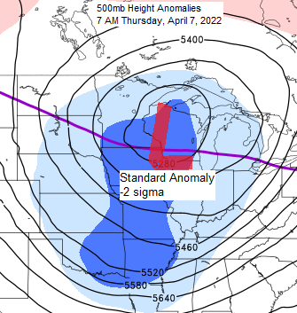
A mid-upper-level area of low pressure was located a little farther NW from where the surface low was late today.

A look at the storm affecting the Northland today on satellite imagery, and wow this is one impressive looking system!
Goes-16 visible loop.

Goes-16 water vapor loop.

A larger view via Goes-16 water vapor imagery.

We’ve seen a reduction in wind speeds in much of the Northland today due to an area of low pressure parked over the area, but as this low moves away the wind will pick up again with northerly winds gusting 20 to around 40 mph from Thursday into Friday.
Wind gust forecast through 7 PM Friday.

- Duluth, Minnesota has already had more snow this month (8.0″ thru April 6) compared to what we had all of March 2022 (6.9″)
- Snowfall total of 8.0″ so far this month at Duluth is 333% of normal thru April 6. In other words, well above average!
- A whopping one day at or warmer than 50 degrees so far this year at Duluth (March 20, high of 55 F) By this time last year Duluth already had 14 days with a high of 50 F or warmer, and 4 days with a high of 60 F or warmer.
Thanks for reading!
Tim
Leave a Reply