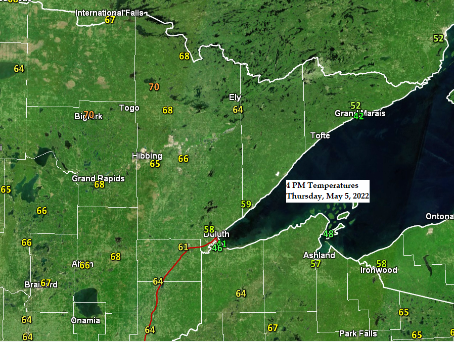
5:26 PM Thursday, May 5, 2022
-Temperatures are warming more than expected today with some locations in the Northland topping out at 70 lovely degrees, otherwise we’re seeing widespread 60s in the Northland today with the typical cooler by the lake (40s). Speaking of Lake Superior, locations closer to the big lake will have a gustier NE wind on Friday (15 to 25 mph).
-Expect similar high temperatures in the 60s to around 70 for Friday and Saturday, with a chance for even warmer temperatures on a few days next week (well into the 70s, possibly as warm as 80 degrees!). It will be a lot cooler, however within about 15 to 20 miles of Lake Superior (highs in the 40s through this weekend).
-Humidity builds next week with dew points climbing into the 50s and perhaps even higher than that at times next week.
-First chance of rain comes Sunday with more chances for showers and thunderstorms throughout next week.
-The Duluth Airport had a high of 61 degrees today, Thursday, May 5th, 2022. This is the first time Duluth has been 60 degrees or warmer since November 6th (high of 64 degrees). The record for latest first 60 in Duluth is May 11th (1950). Last year’s first 60 occurred on March 29th, so the first 60 this year occurred over a month later compared to last year. Note: Mean date for first 60 degree high in Duluth is April 8th.
Rainfall totals of an inch or more are possible over western parts of the Northland through next Saturday, with lesser amounts of rain 0.10″-0.25″ totals in the Arrowhead and for eastern parts of northwest Wisconsin.

A much more amplified pattern is likely next week with strong troughs/upper lows over the western U.S. and over the western Atlantic/southeast U.S., while a massive ridge covers areas from the Southern Plains to the upper Midwest, Great Lakes to eastern Canada. The upper-level ridge is forecast to peak in intensity around the middle of next week, this is when we may see 500mb heights as high as 591 decameters over parts of the Midwest and southern Great Lakes, that is very unusual for May!
Note: High temperatures across parts of the Midwest near the center of the ridge are forecast to top out in the 90s next week with record warmth likely on a few days next week.

Temperature anomaly forecast for next week.

A more active weather pattern continues to look likely for next week with rounds of showers and thunderstorms possible in northeast Minnesota and northwest Wisconsin.
There is a risk for severe thunderstorms on Monday across parts of the upper Midwest (yellow area on map).
The risk for some severe thunderstorms has shifted farther north compared to the forecast on Wednesday with southern portions of the Northland now included in the severe weather risk area for Monday. Additional changes to this forecast are likely over the next few days. Stay tuned.

Lots of sunshine again today from northern Minnesota into northern Wisconsin with a lot more cloud cover the farther south one goes.
Goes-16 visible satellite loop from Thursday, May 5, 2022.

Very warm temperatures in southwest Canada today with temperatures in the upper 70s to 80 degrees, but temperatures are only in the 50s today in much of Iowa and Illinois. This temperature pattern reverses next week with lots of warmth coming to the Midwest while it cools off significantly in western Canada.

Thanks for reading!
Tim
Leave a Reply