6:58 PM Sunday, May 15, 2022
Mainly dry weather is expected in the Northland for Monday and Tuesday with slightly cooler temperatures compared to the last few days. Highs Monday ranging from the low to mid 50s in northern Minnesota to the upper 50s to middle 60s in east-central Minnesota and northwest Wisconsin, and similar highs are expected Tuesday, but an east wind returns on Tuesday so it will be cooler near Lake Superior.
Soil Moisture currently ranks in the 95th-100th percentile across most of northern and northeastern Minnesota (darker green and blue) while more variable soil moisture conditions exist across northwest Wisconsin with some parts of the area wet, other areas near to slightly drier than normal.

FLOOD WARNING INFORMATION
First some good news as the Flood Warning for the North Shore and Arrowhead including portions of Lake and Cook Counties has been cancelled.
-Flood Warning remains in effect for Northern Koochiching County adjacent to the Rainy River. Some locations that will experience flooding areas near the mouth of the Little Fork, Big Fork and Black Rivers including Pelland and Loman.
-Flood Warning remains in effect for the Rainy River Basin including Lake Vermilion, Crane Lake, Namakan Lake, Kabetogama Lake, Rainy Lake, and the Rainy River. Note Namakan Lake has already surpassed the level reached in the 2014 flood and continuing to rise.
-Flood Warning continues until early Tuesday afternoon, May 17 for the St. Louis River at Scanlon. Moderate flooding is occurring, and moderate flooding is forecast. At 9:30 AM Sunday the stage was 11.1 feet, flood stage is 10.5 feet. The maximum river stage in the 24 hours ending at 9:30 AM Sunday was 11.3 feet. The river is forecast to fall below flood stage early Tuesday morning.
-Flood Warning continues until Saturday morning, May 21 for the Mississippi River at Fort Ripley with minor flooding forecast.
-Flood Warning in effect until further notice for the Mississippi River at Aitkin. Minor flooding is occurring, and moderate flooding is forecast. At 9:30 AM Sunday the stage was 14.9 feet, flood stage is 13.0 feet. The river is expected to rise to a crest of 15.2 feet early Monday afternoon. This crest compares to a previous crest of 15.3 feet on May 16, 1986.
Flood Warning (green)


5-Day Significant River Flood Outlook through May 20, 2022.
Significant River Flooding is occurring in red.

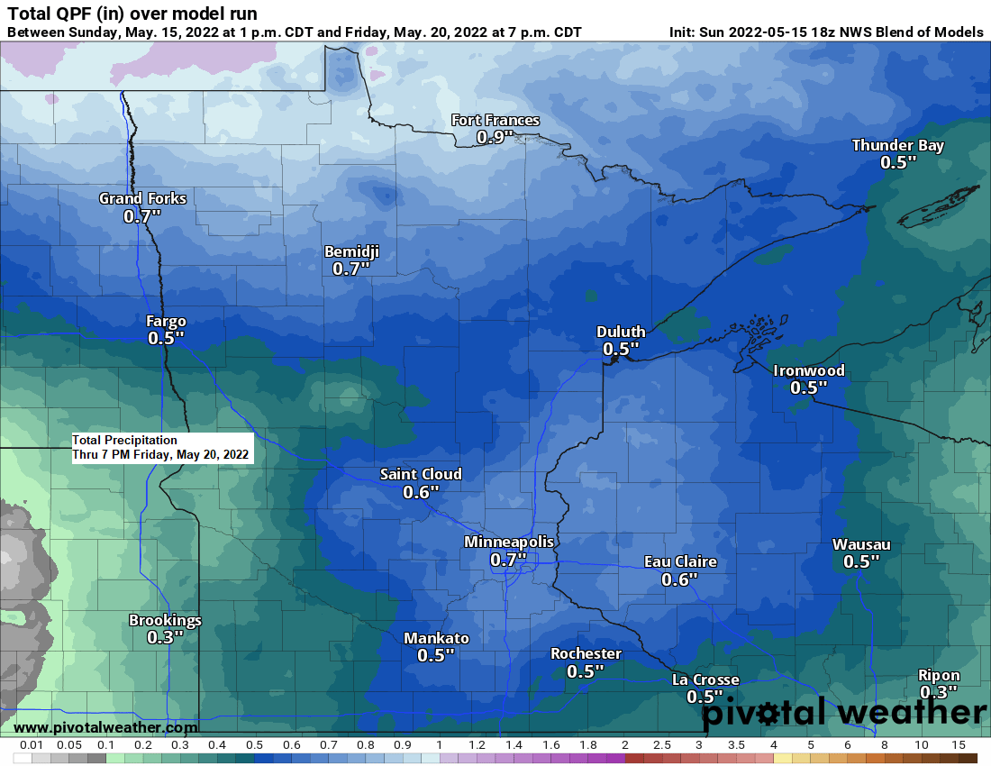
The next few days continue to look mostly dry in northeast Minnesota and northwest Wisconsin, but a more organized system could affect our area later this week (Thursday-Friday) bringing widespread rain to the Northland.
There is also a chance that we see a few thunderstorms on Thursday mainly over east-central Minnesota and northwest Wisconsin but chances for severe weather look relatively low at the moment.

There is at least a 15% chance for rainfall to exceed flash flood guidance (yellow) for Thursday thru early Friday morning.

We could also be talking about some snow or a rain/snow mix in parts of eastern North Dakota and northwest Minnesota, and possibly as far east as northern Minnesota late this week (Friday-early Saturday) but with it being so late into spring atmospheric conditions will need to setup almost perfectly for there to be frozen precipitation later this week, not saying that won’t happen, but will see.
Here’s the European computer model forecast valid from 7 AM Friday, May 20 thru 7 PM Saturday, May 21, 2022.
Snow (blue)
Rain/Snow mix (pink)
Rain (green)

Currently the greatest chances for some accumulating snow Friday and Saturday will be north of the border in parts of Canada, but a few spots in far northern North Dakota could see a few inches of slushy snow later this week.

500mb Height Anomaly Forecast valid May 19-21, 2022.
Troughs/unsettled weather in blue and green.

May 2022 has been a mild one so far with monthly average temperatures running +3 to +4 degrees warmer than average in the Northland – See below.
Brainerd, MN: 56.5 F, +4.4 degrees above average
Duluth, MN: 52.0 F, +3.0 degrees above average
Ashland, WI: 51.7 F, +3.1 degrees above average
International Falls, MN: 51.0 F, +3.3 degrees above average
Hibbing, MN: 49.5 F, +3.1 degrees above average

Warmest temperatures so far this month (thru May 14)
Ashland: 84 F on the 14th
Brainerd: 79 F on the 9th
Duluth: 79 F on the 10th
International Falls: 75 F on the 13th
Hibbing: 73 F on the 10th and 9th
Although May has certainly been much warmer compared to March and April, the spring of 2022 is still running colder than average in much of the Midwest (blue), with spring 2022 ranking as 4th coldest on record thus far in northeastern Minnesota (dark blue area).
Average Temperature/Departure from Normal from March 1, 2022 – May 15, 2022.
Brainerd, MN: 36.3 F, -2.2 degrees below average
Duluth, MN: 33.2 F, -3.0 degrees below average
International Falls, MN: 31.0 F, -3.0 degrees below average
Hibbing, MN: 30.9 F, -2.5 degrees below average

Thanks for reading!
Tim
Leave a Reply