5:58 PM Monday, May 16, 2022
One more dry day ahead in the Northland on Tuesday with rain chances returning starting on Wednesday.
Overall, the next two weeks look pretty wet in northeast Minnesota and northwest Wisconsin with an active pattern likely at times.
Seeing very good ensemble model agreement between the EPS and GEFS models in terms of forecasted rainfall totals thru the end of the month.
There is a chance for another 2-3″+ of rain in the Northland thru May 31.
Note: Duluth was -15.39″ below normal in precipitation when you add up the deficits from 2020 and 2021. We’ve had 9.84″ of precipitation so far in 2022, but we’re still running a deficit of -5.55″ if you go all the way back to 2020 when our two-year drought began. Huge progress has been made in chipping away at the big precipitation deficit we had in Duluth, and if we remain in this wet pattern a while longer, then we should completely erase the deficit we had from the last two years. Unfortunately, the only real way out of that two-year drought is for the kind of pattern we’ve seen this spring which has included frequent precipitation events.


A low-pressure system will pass south of the Northland on Tuesday with rain associated with this system likely staying over southern Minnesota.
Another system on Wednesday takes a more northerly track which increases the chances for scattered showers and isolated thunderstorms in northeast Minnesota and northwest Wisconsin.
NAM 3km model simulated radar forecast valid 7 AM Tuesday thru 9 PM Wednesday.

***FLOOD INFORMATION***
Source National Weather Service Duluth, MN.
New today — A Flood Warning issued for a portion of northeast Minnesota including St. Louis County until 12:15 PM Wednesday.
-Flooding caused by rain and snowmelt is expected. Flooding of rivers, creeks, streams, and other low-lying and flood-prone locations is imminent or occurring. Several structures are flooded, and some sand bagging operations are continuing especially around Hunter and Bowman (Side) Lake. Low-water crossings are inundated with water and may not be passable. This includes Bear Island Road near Island Lake.
-At 12:11 PM Monday, excessive runoff due to rainfall and snowmelt is causing large rises on Island Lake. To prevent further flooding, Minnesota Power is releasing high flows into the Cloquet River which should mitigate the overall flood threat while temporarily increasing the flood threat along the Cloquet River.
-Some locations that will experience flooding include Island Lake, Fredenberg, Taft and Fish Lake.

Flood Warning continues for the following rivers in Minnesota.
Mississippi River at Fort Ripley affecting Crow Wing County.
Mississippi River at Aitkin affecting Aitkin and Crow Wing Counties.
St. Louis River at Scanlon affecting Carlton County.
For the Mississippi River at Fort Ripley — Minor flooding is occurring and minor flooding is forecast through early Saturday morning, May 21, 2022. At 9:30 AM Monday, the stage was 11.1 feet, flood stage is 10.5 feet. The river is expected to fall below flood stage Saturday morning.
For the Mississippi River at Aitkin — Minor flooding is occurring and moderate flooding is forecast until further notice. At 9:30 AM Monday, the stage was 15.1 feet, flood stage is 13.0 feet.
For the St. Louis River at Scanlon — Moderate flooding is occurring and moderate flooding is forecast through early Tuesday afternoon. At 9:30 AM Monday, the stage was 10.7 feet, flood stage is 10.5 feet. The maximum river stage so far this spring occurred Saturday evening and was 11.3 feet. The river is expected to rise to a crest of 10.8 feet Tuesday, May 17. It is then expected to fall below flood stage Wednesday.
Rainy River Basin Flooding Information

Flood Warnings (green)

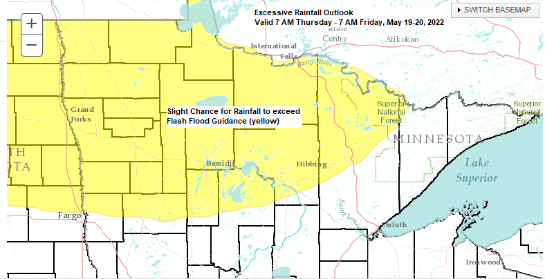
Thursday’s setup is a tricky one as we undergo some quick changes in the atmosphere, but I think the greatest chances for severe thunderstorms Thursday afternoon/evening will setup over the southern half of Minnesota into west-central Wisconsin as those areas look to get into a warmer, more humid and unstable air mass compared to areas farther north including for us in the Northland.


Thanks for reading!
Tim
Leave a Reply