5:54 PM Monday, June 13, 2022
If you live or work near Lake Superior, then just ignore the forecast for Tuesday because the weather will be totally different (shocking I know!) compared to what it will be like oh say 20-30 miles inland from the lake on Tuesday.
- Hot and very muggy Tuesday
- Cooler temps (more seasonable) mid to late week
- Heat dome could return this weekend into early next week
- A few chances for rain, but overall, a pretty dry pattern for the Northland through this weekend
If it weren’t for these very warm temperatures aloft, then we’d likely be dealing with a higher end severe weather event in the Northland on Tuesday since the parameters for severe storms are in the very favorable range to get some nasty storms, but with such a warm air mass aloft, that pretty much eliminates any chance for storms and severe weather in the Northland on Tuesday despite a warm front and cold frontal passage.
Will likely have to wait until Wednesday to get some showers or isolated thunderstorms in our area but this will be post-frontal activity with much less moisture and instability in place in our area by then so the chances for severe weather are slim to none on Wednesday.

HEAT HEADLINES
Heat Advisory in effect from 11 AM Tuesday to 8 PM Tuesday including southern portions of the Northland which includes all of northwest Wisconsin and far eastern Minnesota. Some cities in the Northland in the heat advisory include Solon Springs, Hinckley, Pine City, Danbury, Grantsburg, Siren, Minong, Shell Lake, Spooner, Hayward, Winter, Butternut, Washburn, and Ashland. Highs 87 to 95 with heat index values up to 104.
RECORD HIGHS FOR JUNE 14
Brainerd, MN: 96 (set in 1987)
Ashland, WI: 95 (set in 1988)
Hibbing, MN: 92 (set in 1994)
International Falls, MN: 89 (set in 1973)

Clusters of strong to severe thunderstorms (orange and red on the animation below) continue to erupt over parts of the southern Great Lakes and Ohio Valley this afternoon, or on the northeast side of a large upper-level ridge which covered the central and southern Plains today, and another cluster or two of intense convection will develop tonight over parts of the Dakotas on the northwest side of the aforementioned upper ridge.
Goes-16 sandwich satellite loop from Monday, June 13, 2022.

It was a stormy Monday morning in parts of the Northland as thunderstorms producing vivid lightning and torrential downpours moved across parts of north-central and northeast Minnesota earlier today.
Here are the radar rainfall estimates from Monday morning zoomed in on the Northland, with another larger view of estimated rainfall totals found below.

We saw two main areas of convection this morning, one centered over parts of northern Minnesota and the other across southern Minnesota and that area of storms in southern Minnesota led to areas of flash flooding this morning.

Rainfall Reports from Monday morning, June 13, 2022
Two Harbors, MN: 1.83″
Chisholm-Hibbing Airport: *1.36″ (record rainfall for June 13)
Longville, MN: 1.26″
Grand Rapids, MN: 1.22″
Saginaw, MN: 1.04″
Eveleth-Virginia, MN: 0.84″
Duluth, MN (Airport) 0.68″
Seagull Lake, MN: 0.66″
Ely, MN: 0.61″
Grand Marais, MN (The Bay of Grand Marais) 0.59″
Walker, MN: 0.56″
Cass Lake, MN: 0.45″
Isabella, MN: 0.30″
Grand Marais, MN (Airport) 0.25″
Hill City, MN: 0.18″
International Falls, MN: 0.15″
Ashland, WI: 0.10″
Bigfork, MN: 0.07″
Aitkin, MN: 0.06″
McGregor, MN: 0.05″
Brainerd, MN: 0.02″
Washburn, WI: 0.02″
Cloquet, MN: 0.01″
Duluth Sky Harbor Airport: 0.01″
Superior Airport: 0.01″
Note: An impressive rainfall gradient in the Twin Ports this morning with rainfall totals ranging from 0.68″ at the Duluth Airport to just 0.01″ at the Duluth Harbor and at the Superior Airport.
HAZY
HOT
HUMID
Summer is in full swing as a massive upper-level ridge blanketed the Midwest, central and southern Plains today, and like the Polar Vortex in the winter months, this heat dome will fluctuate west, north, east and south over the next few months.

100-degree temperatures as far north as Nebraska and western Iowa this afternoon, and there is a chance that will see an isolated 100-degree temperature somewhere in southern Minnesota on Tuesday.
Meanwhile near Lake Superior temperatures were in the mid 40s to mid 50s today.

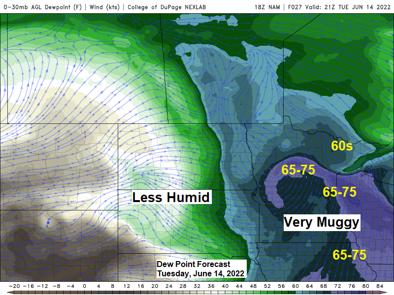
Incredibly high dew points (very muggy feel) ranging from the mid 60s to upper 70s across the Midwest and northern Plains today with even a few 80-degree dew points in the Midwest.

We could be seeing another large heat dome this weekend into early next week, in fact the pattern this weekend looks pretty similar to what it looks like now except that we may see this next upper ridge setup a little farther north/west compared to the current one.
Highs in the 90s to low 100s are possible across the Northern Plains and upper Midwest Saturday through Monday with the hottest temperatures in the Northland forecasted to occur Sunday and Monday (June 19-20) this is when we may see highs of 90+ while temps at night remain at or above 70!
The pattern this weekend looks very amplified which is unusual for this time of year.
The strengths of the two troughs (blue) are forecast to range from -2 to around -4 sigma, while the ridge (red) is forecast to be around +2 sigma for this time of year.

Thanks for reading!
Tim
Leave a Reply