7:55 PM Tuesday, June 14, 2022
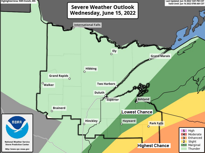
Strong to severe thunderstorms are expected Wednesday mainly from southeast Minnesota into central Wisconsin and southern upper Michigan. Storms that develop in those areas could contain large hail, damaging winds, and possibly a few tornadoes. The risk for severe weather on Wednesday is highest southeast of the Northland, but isolated strong to severe thunderstorms are possible mainly over parts of northwest Wisconsin with a wind and hail threat. Severe weather is not expected in northeast Minnesota on Wednesday.
- A few showers and thunderstorms in far northern Minnesota this evening.
- Scattered showers and thunderstorms possible mainly in northwest Wisconsin and far eastern Minnesota Wednesday.
- Temperatures trend warmer near Lake Superior over the next few days.
- A heat wave remains possible late this weekend into early next week.
A few strong to severe thunderstorms have been moving NE across far northern Minnesota late this afternoon but this convection will exit into southern Canada over the next hour or so with no additional thunderstorms expected in most of the Northland for the rest of tonight due to the passage of a cold front, as well as a layer of very warm temperatures aloft (700mb temps of +12 to +14C) which is helping to put a lid on any further thunderstorm development farther south/east this evening.
MRMS radar loop ending 6:50 PM Tuesday, June 14, 2022.

We had quite the temperature contrast in place today which is not unusual at all at this time of the year.
It’s all about wind direction, and that wind continues to blow out of the NE today which means much cooler temperatures near Lake Superior while about 25 to 35 miles away from Lake Superior it’s a totally different air mass with gusty southerly winds, temperatures in the mid 80s to low 90s with dew points in the 60s to lower 70s.
High Temperature reports from Tuesday, June 14, 2022
Brainerd, MN: 93
Siren, WI: 92
Hayward, WI: 91
Aitkin, MN: 90
Hinckley, MN: 90
McGregor, MN: 90
Solon Springs, WI: 90
Longville, MN: 88
Grand Rapids, MN: 86
Duluth Airport: 68
Cloquet, MN: 63
Superior Airport: 51
Duluth Harbor: 48

Rainfall forecast through Wednesday evening.

A strong area of low pressure stretches from southern Alberta to south-central Saskatchewan late this afternoon with its trailing warm front and cold front extending southeast into Minnesota. This low-pressure system shows up nicely on visible satellite imagery today.

Here’s a regional satellite loop from Tuesday, June 14, 2022, centered on the Central Plains and upper Midwest.
The line of clouds (cumulus) stretching from southern Kansas to central Iowa to eastern Minnesota to western Wisconsin indicates where the cold front was located as of late Tuesday afternoon. Also of note is the milkier colored areas across the upper Midwest which represents haze and possibly even some wildfire smoke this afternoon.

While the rest of the area sees a cool down on Wednesday, locations near Lake Superior will warmup thanks to a wind shift from the NE to an offshore direction, but I’m not totally convinced will completely get rid of this marine layer on Wednesday, and if that is the case then high temps closer to Lake Superior will be in the 50s and 60s instead of the 70s on Wednesday, but it does look like will have a stronger west wind on Thursday which will completely erode the marine layer.

A very amplified weather pattern is forecast to setup this weekend into early next week with deep troughs covering the western US and eastern US while a strong ridge stretches from central Canada to the central and southern Plains.
We could be looking at a multiday heat wave across the upper Midwest this weekend into early next week if this pattern verifies — High temps in the 90s to low 100s are possible from the Northern Plains to upper Midwest from Saturday through Monday, while here in the Northland the hottest days continue to look like Sunday-Monday (June 19-20), this is when we may see widespread 90+ degree high temps in our area.
How warm it gets near Lake Superior and in Duluth will come down to the wind direction. It does look like will have an east wind on Saturday and this may very well carry over into Sunday, and if that happens high temps will only be in the 50s, 60s, and 70s near Lake Superior (coolest closest to the lake) but there is also a chance that winds become southerly on Sunday, and if that happens, then 90+ degree high temps would occur in Duluth and other areas near Lake Superior on Sunday.

A fourth tornado has been confirmed from the Memorial Day storms in the Northland.
Source: NWS Duluth, MN.
Note: The time of this tornado was 6:44 PM – 6:46 PM, and not the time that is shown on the image below.

Thanks for reading!
Tim
Leave a Reply