12:47 PM Tuesday, June 21, 2022
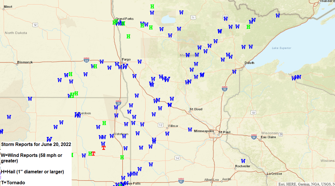
Severe thunderstorms produced widespread wind damage from the eastern Dakotas into western, central and northern Minnesota Monday afternoon into late Monday night.
Local Storm Reports from Monday, June 20, 2022
4:00 AM 6/21: Thunderstorm Wind Damage. Gile, WI (Iron County) Tree down over power pole.
11:50 PM: Thunderstorm Wind Damage. 7 SE Sea Gull Lake, MN (Cook County) Many large pine trees down, several broken halfway up.
11:25 PM: Thunderstorm Wind Damage. 3 WNW Scotts Corner, MN (Carlton County) Young maple trees snapped in half.
11:10 PM: Thunderstorm Wind Damage. 5 SE Markham, MN (St. Louis County) Multiple trees down blocking the south lane on Highway 4.
11:10 PM: Thunderstorm Wind Damage. 3 E Winton, MN (Lake County) Numerous live and dead trees down between 6 and 10 inches diameter at breast height laying down in scattered directions.
11:05 PM: Thunderstorm Wind Damage. Brimson, MN (St. Louis County) Two very large pine trees completely uprooted, fell down from west to east.
11:02 PM: Thunderstorm Wind Damage. 1 SE Brimson, MN (St. Louis County) A couple of large trees blown down.
11:00 PM: Thunderstorm Wind Damage. 3 NE Winton, MN (Lake County) Numerous live and dead trees down.
10:50 PM: Thunderstorm Wind Damage. Alborn, MN (St. Louis County) Large pine tree uprooted and laying over garage.
10:50 PM: Hail 1.00″ (quarter size) 4 N Babbitt, MN (St. Louis County)
10:45 PM: Thunderstorm Wind Damage. Aitkin, MN (Aitkin County) Numerous trees down.
10:45 PM: Thunderstorm Wind Damage. Aitkin, MN (Aitkin County) Widespread small to large trees bent, snapped, and uprooted, many over power lines.
10:45 PM: Thunderstorm Wind Damage. 1 NNW Prosit, MN (St. Louis County) Large tree knocked down.
10:45 PM: Thunderstorm Wind Damage. Aitkin, MN (Aitkin County) Multiple large trees snapped and over roads and house in west Aitkin.
10:43 PM: Thunderstorm Wind Damage. 1 W Aitkin, MN (Aitkin County) Parts of a metal building ripped off and strewn over semi trucks and other property.
10:35 PM: Thunderstorm Wind Damage. 4 WSW Tower, MN (St. Louis County) Medium to large pine trees snapped at base and some with tops snapped off.
10:30 PM: Thunderstorm Wind Damage. Floodwood, MN (St. Louis County) Several trees either damaged, split, or uprooted.
10:15 PM: Thunderstorm Wind Damage. Angora, MN (St. Louis County) 80 foot tall pine tree blown down with more trees reported down in the woods.
10:10 PM: Thunderstorm Wind Damage. 2 S Aitkin, MN (Aitkin County) Large pine tree topped with small branches driven through thinner parts snapped tree.
10:10 PM: Thunderstorm Wind Damage. Aitkin, MN (Aitkin County) Numerous medium to large trees snapped over roads and alleyways.
10:10 PM: Thunderstorm Wind Damage. Ely, MN (St. Louis County) Very large tree snapped approximately 8 feet up from base.
10:08 PM: Thunderstorm Wind Damage. 1 N Gheen, MN (St. Louis County) 80 foot spruce tree uprooted.
9:57 PM: Thunderstorm Wind Damage. 1 S Meadowlands, MN (St. Louis County) Tops of numerous poplar trees broken.
9:48 PM: Thunderstorm Wind Damage. 1 WNW Side Lake, MN (St. Louis County) 4 trees blown down.
9:45 PM: Thunderstorm Wind Damage. 1 WSW Side Lake, MN (St. Louis County) Multiple large pine trees snapped and fallen over buildings, causing some structural damage.
9:30 PM: Thunderstorm Wind Damage. 3 S Calumet, MN (Itasca County) 8 to 10 mid size pine and spruce fallen, partially across county road 70.
9:30 PM: Thunderstorm Wind Damage. 2 NW Nashwauk, MN (Itasca County) Numerous trees down near Highway 65 and county road 8.
9:20 PM: Thunderstorm Wind Damage. 12 N Grand Rapids, MN (Itasca County)
9:19 PM: Thunderstorm Wind Damage. Coleraine, MN (Itasca County) Trees down. One 8 inch diameter pine broken about 5 feet AGL.
9:07 PM: Thunderstorm Wind Damage. Cohasset, MN (Itasca County) Tree down on structure. Possible downburst.
9:06 PM: Thunderstorm Wind Damage. 1 SSE Cohasset, MN (Itasca County) Tree down blocking street.
9:04 PM: Thunderstorm Wind Damage. 6 SSW Grand Rapids, MN (Itasca County) 4 inch diameter branches down. Possible downburst.
8:55 PM: Thunderstorm Wind Damage. Remer, MN (Cass County) Several trees in yard uprooted.
8:55 PM: Thunderstorm Wind Damage. 2 S Days High Landing, MN (Cass County) Large pine tree snapped near base and fallen over bed of truck.
8:50 PM: Thunderstorm Wind Damage. 3 SE Brevik, MN (Cass County) 3 foot diameter willow tree split and broken over.
8:50 PM: Thunderstorm Wind Damage. 1 SW Days High Landing, MN (Cass County) Multiple medium to large trees snapped and uprooted, several partially over roads.
8:35 PM: Thunderstorm Wind Damage. Outing, MN (Cass County) Medium aspen snapped and down.
8:25 PM: Thunderstorm Wind Damage. 1 E Emily, MN (Crow Wing County) Trees down, snapped off and uprooted, up to 18 inches diameter. Road blocked and power pole snapped off of Highway 1.
8:20 PM: Thunderstorm Wind Damage. Crosby, MN (Crow Wing County) Medium tree on car. Two more trees down in neighbors yard.
8:20 PM: Thunderstorm Wind Damage. 1 SW Crosslake, MN (Crow Wing County) Multiple medium to large trees down and snapped in the Crosslake campground, nearly hitting RVS.
8:08 PM: Thunderstorm Wind Damage. Crosby, MN (Crow Wing County) Several trees down.
7:56 PM: Thunderstorm Wind Damage. 1 NNW Brainerd, MN (Crow Wing County) 7 inch tree branches broken. Shingles ripped off house.
7:56 PM: Thunderstorm Wind Damage. 2 ENE Baxter, MN (Crow Wing County) Large attached sign ripped from top of restaurant causing damage.
7:55 PM: Thunderstorm Wind Damage. Brainerd, MN (Crow Wing County) Trees and tree branches snapped and covering a road in Brainerd.
Widespread power outages in wake of Monday night’s severe thunderstorms which hit parts of north-central and northeast Minnesota.
Minnesota Power — 54 active outages affecting 1,281 customers, this is down from a peak of around 11,000 customers without power earlier today.

Lake Country Power — 321 outages affecting 8,187 members.
Counties affected
Aitkin County: 1020
Carlton County: 22
Cass County: 258
Itasca County: 2317
Lake County: 273
St. Louis County: 4297

A decent amount of rain fell with last night’s storms in the Northland with a swath of >2″ of rain per radar estimates centered along a corridor from Brainerd and Aitkin to the McGregor area, and then into western Carlton County.

Rainfall Reports from June 20-21, 2022
McGregor, MN: 2.02″
Brainerd, MN: 1.70″
Duluth Sky Harbor Airport: 1.45″
Hill City, MN: 1.34″
Duluth Airport: 1.34″
Cloquet, MN: 1.31″
Saginaw, MN: 1.25″
Cass Lake, MN: 1.20″
Eveleth-Virginia, MN: 1.05″
Littlefork, MN: 1.04″
Chisholm-Hibbing Airport: 0.94″
Moose Lake, MN: 0.85″
Siren, WI: 0.85″
Two Harbors, MN: 0.84″
Superior Airport: 0.82″
Bigfork, MN: 0.80″
Grand Rapids, MN: 0.63″
Hayward, WI: 0.56″
Glidden, WI: 0.53″
Minong, WI: 0.48″
Isabella, MN: 0.44″
Walker, MN: 0.43″
Clam Lake, WI: 0.40″
Seagull Lake, MN: 0.34″
Solon Springs, WI: 0.33″
Washburn, WI: 0.29″
Hinckley, MN: 0.22″
Ashland, WI: 0.08″
Grand Marais, MN: 0.07″
Thanks for reading!
Tim
Leave a Reply