5:39 PM Thursday, July 28, 2022
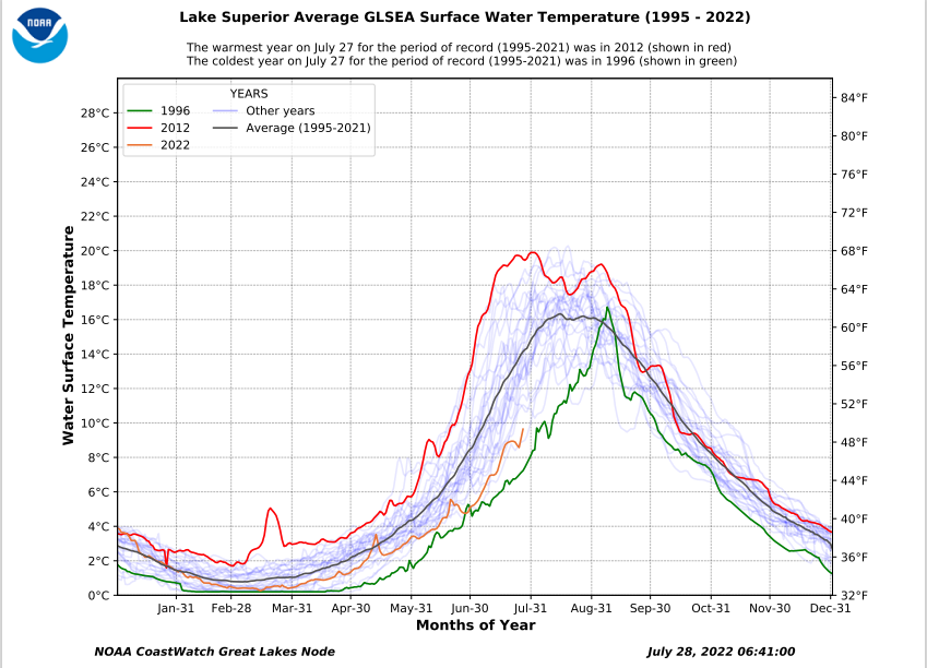
The water temperature of Lake Superior continues to run well below normal here in late July. Typically, by this time of year the average water temperature of Lake Superior is between 56-58 degrees, but this year we still have an average water temperature of around 48-49 degrees, what this means is that anytime the wind is out of the east this may lead to temperatures being quite a bit cooler compared to what we typically see near Lake Superior late in the summer which is less of a cooling effect whenever the wind is out of the east since water temperatures are usually quite a bit warmer by the time we get into August, but this isn’t the case this year.
Warmer temperatures will return to the Northland over the next few days with highs mainly in the 70s on Friday, warming into the 80s Saturday and Sunday, but the humidity won’t really start to increase until Sunday, that’s when dew points climb into the 60s. We could also see some showers or thunderstorms return to the area later this weekend as a cold front moves into the upper Midwest.
Short Term — Scattered showers with brief downpours and gusty winds will continue in the Northland through about midevening before we see these showers diminish.
Radar loop ending 5:10 PM Thursday, July 28, 2022.

We’ve seen a few pockets of very heavy rain which has led to major flooding over parts of the Midwest over the last few days.
One area that was hit hard was around the St. Louis area on July 26, and this morning (July 28) parts of eastern Kentucky saw major flooding due to excessive rainfall totals.
Parts of northeast Minnesota also picked up some impressive rainfall totals on July 26, with Hibbing recording 2.31″ of rain which set a new daily rainfall record for July 26.

It’s either been too wet or too dry in Minnesota this summer, just depends what part of the state you’re in.
Drought continues to expand in parts of southern, central and eastern Minnesota with 30% of the state abnormally dry, while 6% of the state is in moderate drought, with 1% of the state (centered mostly over the Twin Cities metro) in severe drought.

45% of Wisconsin is abnormally dry, up from 34% last week.
7% of Wisconsin is in moderate drought, up from 5% last week.

A look at drought conditions across the Midwest.

Drought monitor class change over the last 8 weeks (July 26, 2022, compared to May 31, 2022)

Soil moisture conditions as of Wednesday, July 27, 2022.
Yellow, orange, and red – Dry
Green and blue – Wet

Thanks for reading!
Tim
Leave a Reply