11:51 AM Sunday, July 31, 2022
Here’s a look at the climate normals and records for the month of August at Duluth, Minnesota.
Normal high on the 1st: 78
Normal high on the 31st: 73
Normal low on the 1st: 57
Normal low on the 31st: 53
Average monthly temperature: 65.5 degrees
Warmest August on record: 70.2 degrees set in 1930
Coldest August on record: 57.5 degrees set in 1912
Normal precipitation in August: 3.73″
Wettest August on record: 10.31″ set in 1972
Driest August on record: 0.29″ set in 1930
Normal number of 80-degree days in August: 8
Normal number of 90-degree days in August: 1
Astronomical Data for August at Duluth, Minnesota
Sunrise on the 1st: 5:49 AM CDT
Sunrise on the 31st: 6:26 AM CDT
Sunset on the 1st: 8:41 PM CDT
Sunset on the 31st: 7:49 PM CDT
Temperature and Precipitation stats for meteorological summer 2022
June 1 through July 30
Note, the final day of meteorological summer is August 31.
Average temperatures so far for the summer of 2022 are running near normal to slightly warmer than normal in most of the Northland, except in the Arrowhead of Minnesota which is running cooler than normal so far this summer.
Brainerd, MN: 69.0 F, +1.6 degrees above normal
Duluth, MN: 64.3 F, +0.3 degrees above normal
International Falls, MN: 63.1 F, +0.3 degrees above normal
Hibbing, MN: 61.5 F, +0.3 degrees above normal

Total Rainfall, departure and percent of normal
Rainfall patterns have been pretty crazy this summer, with International Falls picking up nearly 9″ of rain so far this summer, while Minneapolis hasn’t even cracked the 3″ mark for rainfall the entire summer thus far!
International Falls, MN: 8.99″, +1.33″ above normal (117% of normal)
St. Cloud: 7.64″, +0.40″ above normal (105% of normal)
Duluth, MN: 6.88″, -1.32″ below normal (84% of normal)
Twin Cities, MN: 2.30″, -6.21″ below normal (27% of normal)


Long Range Forecast for August 2022
Temperatures
Above normal temperatures are expected in northeast Minnesota and northwest Wisconsin, but Lake Superior may have something to say about that for locations along the North Shore and South Shore as water temperatures continue to run well below normal on Lake Superior.

Temperature anomaly trend for August 2022 per last 8 model runs from the CFS model.

Precipitation
Near normal to below normal precipitation is expected in northeast Minnesota and northwest Wisconsin.

Precipitation anomaly trend for August 2022 per last 8 model runs from the CFS model.

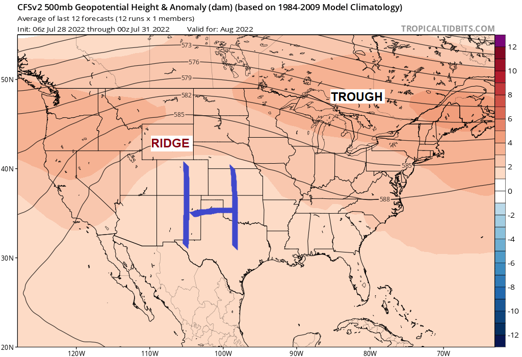
500mb height anomaly forecast for August 2022 per last 8 model runs from the CFS model.
Not a whole lot of change in the 500mb pattern compared to what we’ve already seen this summer which is a continuation of a NW flow for the upper Midwest and Great Lakes while a ridge (heat dome) covers the Rockies and Plains. Some shakeups to this pattern are possible during the month as this just shows what the average 500mb pattern should look like for August 2022.
The most intense/persistent heat in this type of pattern should remain locked up farther west/south of the Northland in August, but some shots of heat are still possible throughout the month, but the real warm stuff likely won’t stick around very long.

Thanks for reading!
Tim
Leave a Reply