5:35 PM Friday, September 9, 2022
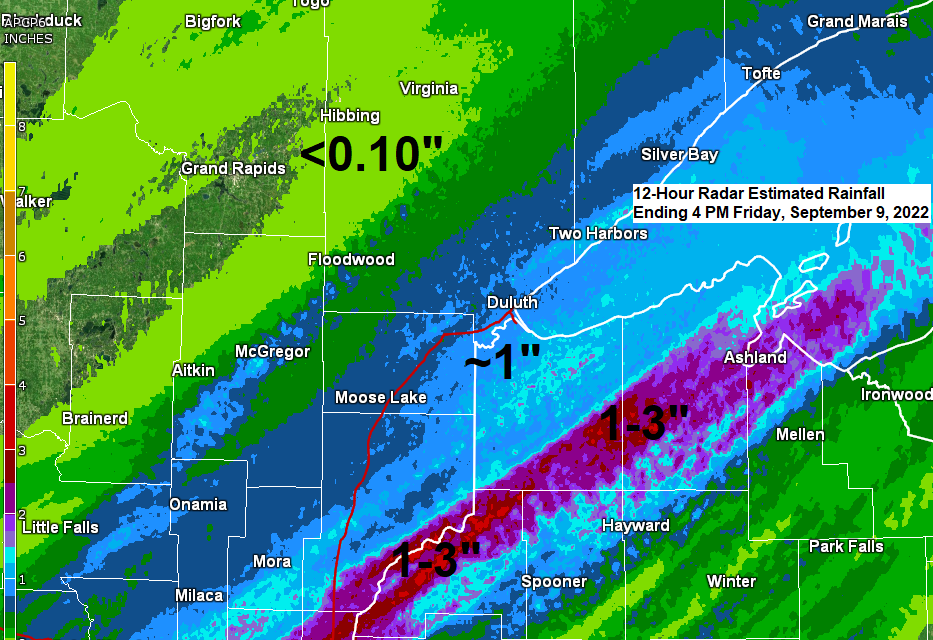
We saw quite a rainfall gradient over the Northland today with some parts of northwest Wisconsin picking up 1 to nearly 3 inches of rain, with around an inch of rain reported from Hinckley to Duluth and along the North Shore of Lake Superior, but then we saw rainfall amounts taper off considerably a little farther west, with Hibbing and Brainerd only picking up <0.10″ of rain today.
Note: A new daily rainfall record for September 9th was set today at Ashland, Wisconsin with 1.92″ of rain so far today (thru 4 PM). The previous wettest September 9th was set in 1929 with 1.85″ of rain.
Going into today soil moisture conditions ranged from 0 to 5% from the Twin Ports, south to the Holyoke and Bruno area, and east along the South Shore in northwest Wisconsin (black outlined area), so today’s rain was definitely a good thing even if the timing of it sucked, but that’s weather for ya!

Rainfall Reports from Friday, September 9, 2022 (thru 4:30 PM)
Source: MesoWest
Webb Lake, WI: 2.96″
Barnes, WI: 2.32″
Washburn, WI: 2.04″
Solon Springs, WI: 1.96″
Ashland, WI: 1.92″
Odanah, WI: 1.89″
Minong, WI: 1.83″
Danbury, WI: 1.78″
Poplar, WI: 1.61″
Two Harbors, MN: 1.58″
French River, MN: 1.30″
Bayfield, WI: 1.28″
South Range, WI: 1.11″
Hinckley, MN: 1.05″
Duluth Sky Harbor Airport: 0.98″
McGregor, MN: 0.96″
Duluth Airport: 0.93″
Siren, WI: 0.92″
Spooner, WI: 0.88″
Cloquet, MN: 0.86″
Grand Marais, The Bay of Grand Marais, MN: 0.85″
Saginaw, MN: 0.81″
Moose Lake, MN: 0.75″
Cable, WI: 0.73″
Shell Lake, WI: 0.57″
Hayward, WI: 0.52″
Isabella, MN: 0.40″
Clam Lake, WI: 0.33″
Seagull Lake, MN: 0.28″
Aitkin, MN: 0.21″
Glidden, WI: 0.17″
Winter, WI: 0.14″
Cass Lake, MN: 0.12″
Ely, MN: 0.12″
Brainerd, MN: 0.11″
Walker, MN: 0.08″
Eveleth-Virginia, MN: 0.08″
Bigfork, MN: 0.07″
Orr, MN: 0.07″
International Falls, MN: 0.06″
Chisholm-Hibbing Airport: 0.05″
Hill City, MN: 0.02″
Longville, MN: 0.02″
Pine River, MN: 0.01″
Grand Rapids, MN: 0.01″
Rain will continue this evening over parts of northwest Wisconsin, with a few showers also affecting parts of northern Minnesota. Rain is expected to gradually end in both areas later tonight.
This weekend is looking mostly dry in the Northland, but we could see a few showers over far northern Minnesota Saturday afternoon.
18z HRRR model radar forecast through 7 PM Saturday.

Quite a strong cold front moved through the region earlier today bringing much cooler temperatures and widespread rain to the area.
Temperatures this afternoon are running about -15 to -30 degrees cooler compared to Thursday afternoon over much of Minnesota into western and northern Wisconsin.

Actual temperatures are only hovering around the 60-degree mark over much of northeast and east-central Minnesota into northwest Wisconsin this afternoon, while much warmer temperatures were found farther to the southeast, while temperatures are a little warmer farther to the northwest.

Highs on Saturday are forecast to range from the mid 60s to around 70 in northeast Minnesota and northwest Wisconsin, and Sunday’s highs look pretty similar, so a very typical early September temperature pattern in our area.

A mix of sun/clouds over western and northern Minnesota this afternoon, with more sun farther to the southeast, while in between we’re seeing widespread clouds over northeast and eastern Minnesota and western and northern Wisconsin.

LONG RANGE FORECAST
Looks like the upper Midwest will have higher 500mb heights along with upper-level ridging for much of next week with troughs located to the southeast, and over the far western U.S.
There are signs, however, that we could get some rain at times mid to late next week as a frontal boundary sets up over the upper Midwest.

No signs yet of any major or prolonged cool snap impacting the Northland, instead we’re looking at another week of warmer than normal temperatures with a shot at 70+ degree temps on a few days next week.

Thanks for reading!
Tim
Leave a Reply