5:15 PM Monday, September 12, 2022
The weather will remain on the quiet side in the Northland the next few days, but some changes are likely late this week into early next week as we see quite a change in the upper-level pattern where we see a ridge setup over the Midwest, Ohio Valley and Great Lakes while a trough develops over the western U.S. — This type of pattern will put the upper Midwest in a more active SW flow aloft late this week through early next week with several chances for rain.
Here’s the 500mb height anomaly valid September 16-21, 2022.

RAIN CHANCES LATE THIS WEEK
An area of low pressure with its warm front and cold front will move into the upper Midwest by way of the northern Plains on Thursday. A warm and moist advection pattern developing ahead of this system should cause some rain to develop at times over parts of the Northland Thursday into Friday. Note: The potential for thunderstorms late this week looks fairly low at this time due to a lack of instability.

| Rainfall Totals and Departure from normal for September 2022 (thru 4 PM on the 12th) Ashland, WI: 2.00″ Departure: +0.84″ above normal Duluth, MN: 0.92″ Departure: -0.51″ below normal Hibbing, MN: 0.21″ Departure: -1.10″ below normal Brainerd, MN: 0.10″ Departure: -0.89″ below normal International Falls, MN: 0.06″ Departure: -1.18″ below normal |
Percent of Normal Precipitation for September 2022 (thru the 11th)
Dark red: 25% or less of normal
Red: Around 50% of normal
Yellow and green: 90 to 110% of normal

HEAVY RAIN POTENTIAL LATE THIS WEEK
There is a potential for rainfall to exceed flash flood guidance Thursday into Friday morning over parts of northeastern Minnesota (north of Duluth)

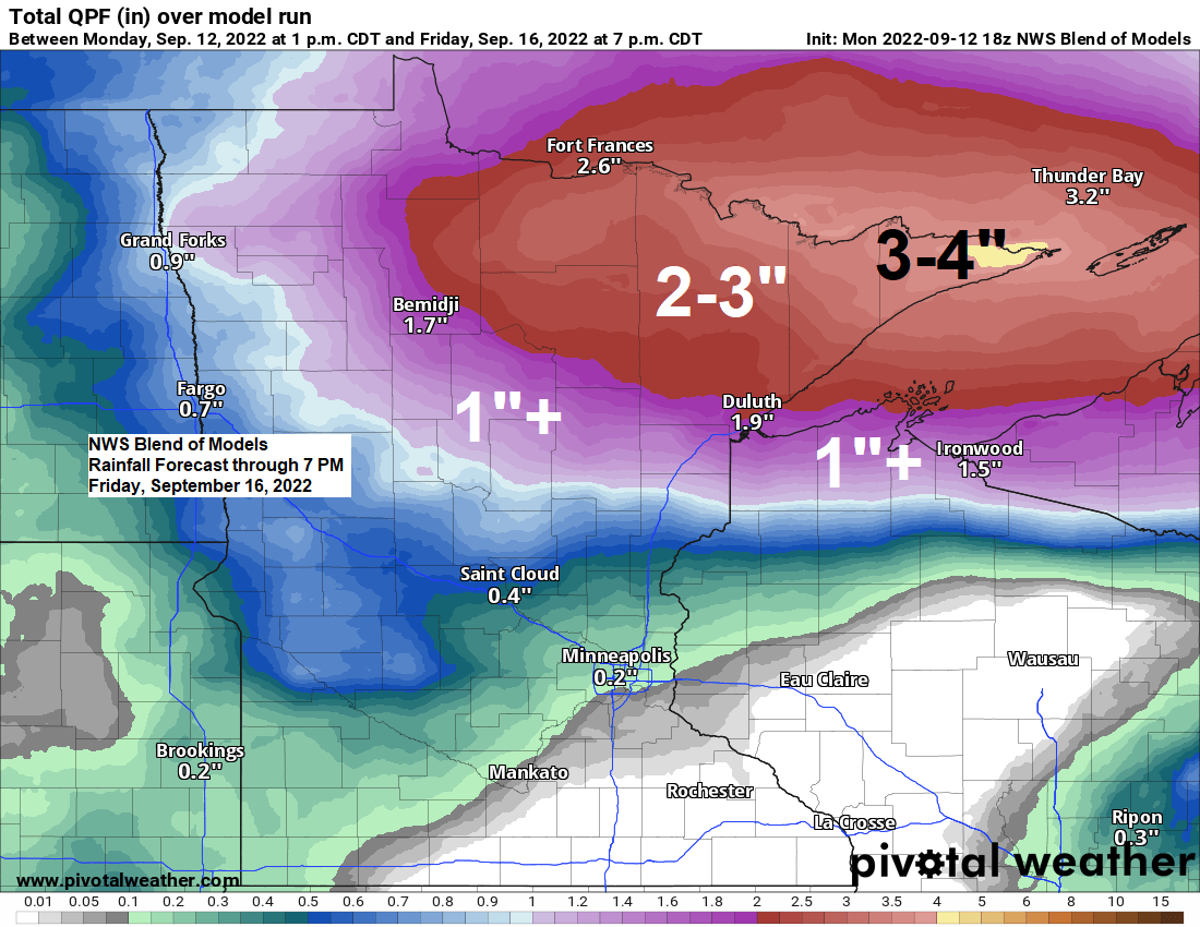
A look at forecasted rainfall totals for Thursday into Friday.
Greatest rainfall amounts are expected to be along and north of Highway 2 in northeast Minnesota where there is a chance for 2-3″+ totals.

Soil moisture conditions are running near to above normal across much of northern Minnesota with the green areas representing soil moisture conditions of 70-80% of normal as of September 12, 2022.
But we still have a pocket of drier than normal soil conditions (black outlined area) around the head of Lake Superior including from the Twin Ports east along the South Shore of Lake Superior, this despite the recent rain we saw late last week.

For those looking for a more persistent cool down, well no signs of that happening just yet, in fact it looks like will be seeing warmer than normal temperatures in northeast Minnesota and northwest Wisconsin late this week into early next week with several days of highs of 70 or warmer looking likely.

A strong upper-level low pressure system continues to move slowly ENE across the Midwest and Ohio Valley today. Heavy rain occurred with this system the last few days over south-central and eastern Wisconsin with some flooding reported.
Goes-16 visible satellite loop from Monday, September 12, 2022 (ending 4:06 PM)

A look at the upper low over the Midwest today via Goes-16 water vapor loop (ending 4:16 PM Monday)

Rainfall amounts of 2 to 5″+ have been common over the last 24 hours from southern to eastern Wisconsin.

Thanks for reading!
Tim
Leave a Reply