5:50 PM Thursday, October 13, 2022
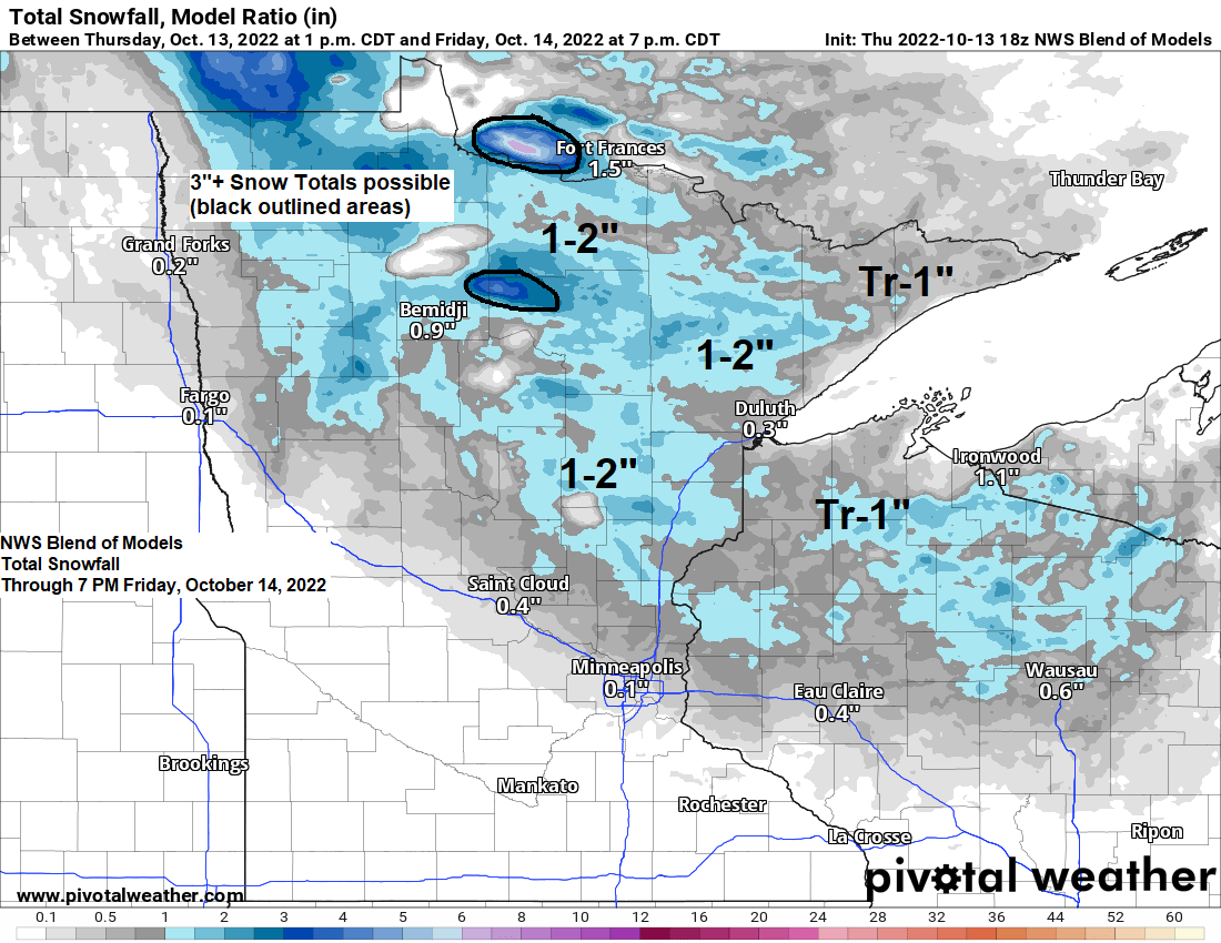
Much of the Northland will likely see a dusting of snow on the ground by late Friday morning, and for some parts of the area it may be more than a dusting, with upwards of a few inches of snow possible as the first widespread light snowfall event of the season affects the Northland late tonight through Friday morning. Here we go!
-Precipitation should be most widespread later this evening through Friday morning followed by lingering isolated to scattered coverage precipitation Friday afternoon.
-As for precipitation types — Everything is pointing toward this being mainly snow late tonight through Friday morning with a transition to rain or a mix of rain/snow showers Friday afternoon as surface temps warm a bit.
-Most of the accumulating snow should occur late tonight through Friday morning, and most of the snow accumulation should remain on grassy surfaces, but some roads may even become slush/snow covered in some parts of the Northland for a time early Friday morning especially if snowfall rates are heavy enough.
| The mean date for the first 0.1″ or greater snowfall in Duluth is October 24th (1948-2021 climate period) Here’s a look at when the first 0.1″ snowfall occurred in Duluth from 2017-2021. 2021: November 1st 2020: October 17th 2019: October 11th 2018: October 10th 2017: October 27th |
Timing for Duluth — The most widespread precipitation looks to fall overnight tonight through about mid-morning on Friday (roughly 3 AM to 8 AM) with a few showers before and after that time. Precipitation types will vary between rain and snow this evening and again Friday afternoon, but during the period of most widespread precipitation Friday morning, snow should be the main precipitation type, except closer to Lake Superior (lower elevation) where precipitation could stay mostly in the form of rain. Total snowfall accumulations of <1″ for Duluth.
18z NAM 3km model radar forecast through 7 PM Friday.
Snow (blue)
Rain (green)

A strong mid/upper-level low pressure system currently over Ontario will drop south into Minnesota on Friday and then it will exit off to the east-northeast this weekend, but a large trough covering areas from central Canada to the Great Lakes and Ohio Valley won’t be moving much through early next week, and as long as this trough is over our area expect chilly temperatures along with occasional scattered rain and snow in the Northland.
Goes-16 water vapor loop for October 13, 2022 (loop time ends 4:20 PM)

Temperatures at 500mb or at around 18,000 feet will range from -25 to -30C in the Northland tonight and Friday, and again on Sunday as a reinforcing shot of cold air moves into the Northland.
All of this cold air is associated with the aforementioned upper trough/low over central Canada.
Here’s the 18z NAM 500mb forecast through 7 PM Sunday.

This is a cold pattern for the Great Lakes, Midwest and Ohio Valley, and this cold air looks like it will stick around into early next week, but there is a chance that will see warmer temperatures and ridging shift farther east out of western Canada and the Pacific northwest and into the Plains and upper Midwest later next week but there is quite a bit of uncertainty showing up in model guidance on how the pattern sets up later next week.

| Total Precipitation, departure and percent of normal since September 1, 2022. Duluth, MN Total: 2.80″ Departure: -1.93″ below normal Percent of normal: 59% of normal Hibbing, MN Total: 2.76″ Departure: -1.31″ below normal Percent of normal: 68% of normal International Falls, MN Total: 2.51″ Departure: -1.42″ below normal Percent of normal: 64% of normal Brainerd, MN Total: 2.07″ Departure: -1.64″ below normal Percent of normal: 56% of normal |
Drought Update — October 13, 2022
Minnesota
4% of the state is in Extreme Drought, up from 3% last week.
12% of the state is in Severe Drought, up from 11% last week.
36% of the state is in Moderate Drought, up from 34% last week.
79% of the state is Abnormally Dry, up from 77% last week.
Note: 3 months ago, 88% of Minnesota was drought-free. Fast forward a few months and now just 20% of Minnesota is drought-free as of October 11, 2022.

Wisconsin
3% of the state is in Severe Drought, unchanged from last week.
19% of the state is in Moderate Drought, up from 12% last week.
57% of the state is Abnormally Dry, up from 53% last week.

Drought Monitor Class Change in the Northland for the 12-week period from October 11, 2022, compared to July 19, 2022.
Orange colored areas — 1 to 3 class degradation

Only 18% of the US is drought-free as of the October 11, 2022, drought monitor update.
The areas outlined in black are seeing the worse drought conditions.

U.S. Drought Monitor Class Change for the 4-week period from October 11, 2022, compared to September 13, 2022.

Here’s the Drought Monitor Class Change for the Midwest for the 12-week period from October 11, 2022, compared to July 19, 2022.

Thanks for reading!
Tim
Leave a Reply