5:42 PM Tuesday, November 1, 2022
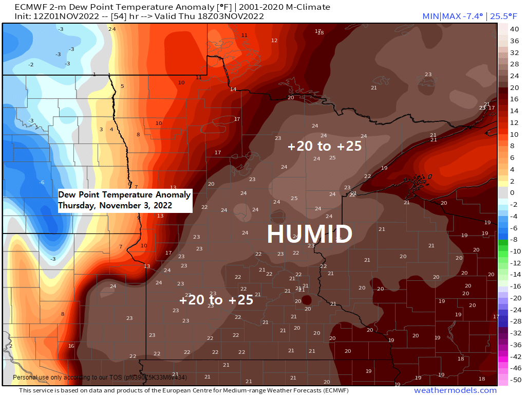
Unseasonably warm weather continues in the Northland through Thursday, and it will also be feeling a little on the muggy side on Thursday as dew points climb into the 50s in much of the Northland, how’s that for early November!
The increasing amounts of moisture along with a warm air advection pattern may be just enough to build up enough elevated instability to spark a thunderstorm or two in the Northland Thursday afternoon or Thursday night.
Temperatures do cool off (closer to normal values for early November) Friday through the weekend with highs mostly in the 40s, but a few 50s are possible in parts of northwest Wisconsin.
Today, November 1 marked the 5th day in a row with a high temperature of at least 60 degrees in Duluth.
Back in November of 2020 we had another stretch of very warm weather in the upper Midwest including here in Duluth – Here’s a look at the high temperatures in Duluth from November 2-9, 2020.
11/2: 51 F
11/3: 70 F
11/4: 73 F
11/5: 60 F
11/6: 75 F
11/7: 62 F
11/8: 69 F
11/9: 65 F
*The mean date for the last 70-degree temperature at Brainerd, Minnesota is October 14th. High was 73 at Brainerd today (November 1)
*Latest last 70-degree temperature on record at Brainerd occurred on November 8th (2020)
*Dating back to 1899 there’s only been 6 years where a 70-degree temperature occurred after October 31st at Brainerd (1975, 2001, 2008, 2016, 2020 and now 2022)
| A look at the record highs which were broken or tied in the Northland today, Tuesday, November 1, 2022. Brainerd, Minnesota New record high: 73 Old record high: 69 set in 1944 and 1990 Duluth, Minnesota Tied the record high of 68 – This record was set in 1990 ***RECORD HIGH TEMPERATURES FOR NOVEMBER 2ND*** Duluth, MN: 71 set in 1903 Ashland, WI: 70 set in 1944 and 1938 Internatinal Falls, MN: 67 set in 1978 Hibbing, MN: 66 set in 1978 Brainerd, MN: 65 set in 2015, 1981 and 1917 |
Record to near record warmth was widespread across the upper Midwest on this 1st day of November 2022.
Red – New record high temperature for 11/01
Orange – Tied the record high temperature for 11/01

Incredible warmth for early November, and just look how widespread this warmth was today.

Temperatures were running +15 to +25 degrees warmer than average across the region this afternoon.

We have a few chances for precipitation in the Northland late this week into this weekend.
The first system consists of a cold front moving east out of the Northern Plains. Increasing amounts of forcing near this boundary will cause rain showers and isolated thunderstorms to develop in much of the Northland Thursday afternoon through Thursday night.
A second system could hit the Northland this weekend, but this one is much more complex compared to the first system, and that’s because of different pieces of energy which will be moving east/northeast out of the Plains. How much phasing occurs is still uncertain, but basically the more phasing we get the deeper the surface low will be, while less phasing would tend to lead to a weaker surface low lifting northeast into the Great Lakes, but whether the low is a strong one or a weaker one won’t make much of a difference since it looks like this would be a very fast-moving system.
The greatest chances for widespread rain in northeast Minnesota and northwest Wisconsin with this second system would be on Saturday with lower chances for precipitation Sunday.
Temperatures still look warm enough for precipitation to fall mainly in the form of rain in the Northland on Saturday, but if we can get enough dynamical cooling to occur, then it’s not out of the question that we could see a rain/snow mix develop in some parts of the area on Saturday, but this doesn’t look like a big snow event for the Northland.
Here’s the 500mb setup for the second system — Different pieces of energy outlined in black and red.

Here’s the 500mb forecast valid Friday evening (7 PM) through Tuesday morning (6 AM) November 4-8, 2022.
Lower heights/troughing in blue and green
Higher heights/ridging in orange, red and white
Note how the trough is replaced by another ridge across the upper Midwest as we get into early next week as the pattern reloads farther off to the west.

Here’s the total precipitation forecast through Noon on Sunday.
Greatest amounts of 1″+ covers the Arrowhead into far eastern Minnesota and all of northwest Wisconsin with some 2″+ totals possible in parts of northwest Wisconsin.
Lower precipitation amounts ranging from around 0.10″ to 0.50″ are possible in western portions of the area including from the Brainerd Lakes north to International Falls.

Next week is trending warmer in the Northland with any colder risks now delayed until mid to late next week.
Note the changes from yesterday to today with next week’s temperature anomalies in the Northland (black outlined area)
EPS model


And the GEFS model agrees with the EPS model for these warmer trends for next week.
Blue and Purple – Below average temperatures
Orange and Red – Above average temperatures

Thanks for reading!
Tim
Leave a Reply