2:59 PM Sunday, November 20, 2022
The arctic air is gone for now as a milder temperature pattern takes over for about the next week or so.
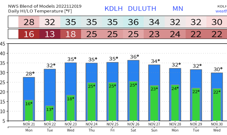
Here in northeast Minnesota and northwest Wisconsin we’re looking at daytime highs mostly in the 30s starting on Tuesday, and then continuing through next weekend. The forecasted highs this week will be running very close to normal to a little above normal in our area for this time of the year.
Note: There is a chance that temperatures will climb toward the 40-degree mark in parts of the Northland on a few days from about midweek through next weekend.
EPS model temperature anomaly forecast for November 24-29, 2022.

GEFS model temperature anomaly forecast for November 24-29, 2022.

GEFS model temperature anomaly trend (last 4 model runs) for November 24-29, 2022.
Orange and red – Above normal temperatures
Blue – Below normal temperatures

Although the week ahead looks generally quiet in terms of any major storm systems impacting the upper Midwest, there will still be a few systems which will move through the region. One on Tuesday, and another in the Wednesday night-early Friday time frame.
The system for mid to late week doesn’t really strengthen until it gets east of our area so at the moment it doesn’t look like will see much snow or rain in our area with that system.
Here’s the 500mb height anomaly forecast for November 23-26, 2022.
Lower 500mb heights/troughs in blue and green
Higher 500mb heights/ridging in orange and red

The system on Tuesday has a chance to produce up to an inch of snow in far northern Minnesota (near the Ontario border) but little to no snow is expected farther south.

Lots of snow cover showing up on the Goes-16 Day Cloud Phase satellite imagery from Sunday afternoon, November 20, 2022.
Snow cover in green
Pink/white areas=Cloud cover

A very warm open to November 2022 has turned considerably colder over the last week or so which is causing the above average temperature anomalies observed earlier this month to quickly fade away, with much of the Northland now running very close to average for the month.
| Average Temperature and Departure from Average for November 2022 (thru the 19th) Ashland, WI: 35.9 F; +1.2 degrees above average Brainerd, MN: 34.0 F; -0.6 degrees above average Duluth, MN: 32.8 F; +0.3 degrees above average Hibbing, MN: 29.5 F; +1.1 degrees above average International Falls, MN: 28.7 F; -0.5 degrees below average |

It’s been a very wet November in the Northland with precipitation totals for the month so far ranging from around 1.25″ to nearly 3.75″.
| Total Precipitation and Departure from Average for November 2022 (thru the 19th) Ashland, WI: 3.73″; +2.68″ above average Duluth, MN: 3.38″; +2.07″ above average Hibbing, MN: 1.98″; +1.22″ above average Brainerd, MN: 1.83″; +1.17″ above average International Falls, MN: 1.32″; +0.34″ above average |

Percent of Normal Precipitation for November 2022 (thru the 19th)
Ashland, WI: 355% of normal
Brainerd, MN: 277% of normal
Hibbing, MN: 261% of normal
Duluth, MN: 258% of normal
International Falls, MN: 135% of normal

| Total Snowfall, Departure and Percent of Normal for November 2022 (thru the 19th) International Falls, MN Total: 11.6″ Normal: 6.6″ Departure: +5.0″ above normal Percent of normal: 176% of normal Duluth, MN Total: 10.1″ Normal: 8.0″ Departure: +2.1″ above normal Percent of Normal: 126% of normal |

The first subzero temperatures of the season occurred in the Northland this morning, Sunday, November 20th, 2022.
| Low Temperature Reports from Sunday, November 20, 2022 Source: NWS Duluth, MN 3 E Wright, MN: -3 F 2 S Tower, MN: -3 F Cook, MN: -2 F International Falls, MN: -1 F Butternut, WI: -1 F Orr, MN: 0 F Crane Lake, MN: 0 F Hibbing, MN: 1 F Hayward, WI: 1 F Grand Marais, MN: 2 F Walker, MN: 2 F Solon Springs, WI: 3 F Bigfork, MN: 3 F Duluth Airport: 5 F Superior Airport: 6 F Duluth Sky Harbor Airport: 9 F Note: Low temperature of 5 degrees at the Duluth Airport on November 20, 2022, this is the coldest temperature since March 28, 2022 (low of 3 degrees) |
Thanks for reading!
Tim
Leave a Reply