6:03 PM Thursday, December 8, 2022
I’ve picked up a few new followers recently on Facebook, and I’ve also noticed that my blog has had quite an increase in views over the past few days, so hello to all!
Some may have noticed that my background theme has been changing around a bit lately as I’m trying to find a new layout/theme for my blog, but I think I’ve finally found the one I plan on sticking with, so will see how that goes.
Let’s talk weather
- Some snow on the way for Saturday with the highest amounts along the North Shore of Lake Superior
- There is a potential for some patchy fog late tonight through Friday morning, and again Friday night-Saturday and this is when we may also see some patchy freezing drizzle
- A major storm could impact the Northland next week (Dec. 13-15) time frame
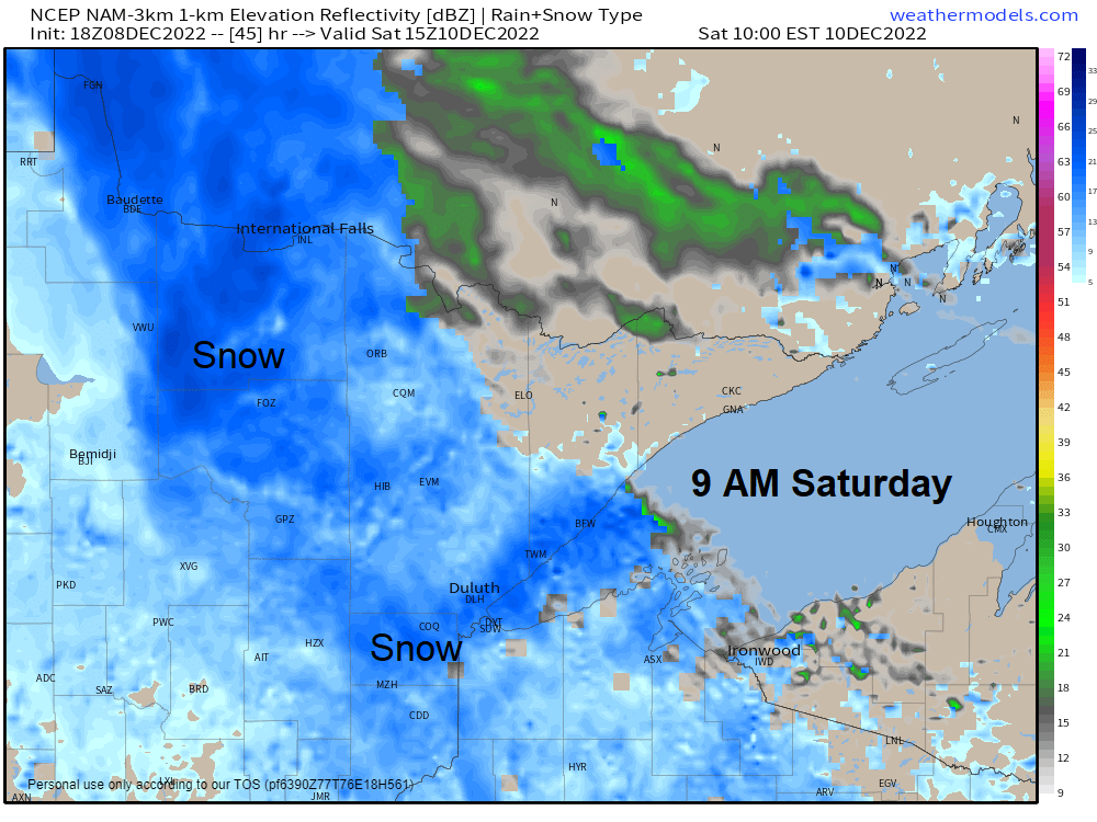
Saturday Snow Chances
An inverted trough will move across the area on Saturday bringing some snow to northeast Minnesota and northwest Wisconsin. Heavy snow amounts are unlikely with this system, but there could be enough snow to cause some travel issues especially along the North Shore of Lake Superior where terrain enhanced snowfall is likely with ESE winds crossing Lake Superior.
Most of the snow on Saturday falls during the day with snow tapering off Saturday evening/overnight.
18z NAM 3km model radar forecast valid Midnight Saturday to Midnight Sunday.

Here’s my snowfall forecast for Saturday.
2 to 4 inches possible along the North Shore of Lake Superior.
For Duluth – About 1 to 2 inches of snow.

Update on Next Weeks’ Storm
A large and slow-moving mid/upper-level trough and low is forecast to move ashore in the Pacific northwest later this weekend. This system is then expected to track ENE through the Rockies and into the Plains and Midwest and eventually into the eastern Great Lakes by late next week.
This is the system that could impact the Northland in a big way during the December 13-15 time frame.
500mb Height Anomaly Forecast valid December 11-16, 2022
Lower heights/troughs in blue and green
Higher heights/ridging in orange, red and gray

Ensemble models continue to be in good agreement as they all show a strong area of low pressure moving northeast out of eastern Colorado on Monday, however, there continues to be some differences on timing, and just how far north the area of low pressure will track, with the CMCE (Canadian ensemble model) furthest north, while the EPS and GEFS models have trended further south, especially the EPS model compared to 24 hours ago.
Note – One of the main takeaways from today’s model runs is that this system has slowed down quite a bit meaning that a lot of the precipitation that we may see in the Northland would occur more in that Tuesday night to Thursday time frame. Whether or not these slower trends continue the next few days remains to be seen.
All three ensemble models are still showing a significant amount of QPF (precipitation) across the Northland next week, centered on the Tuesday-Thursday time frame, and this has been consistent now for a few model runs.
What type of precipitation we see in the Northland will depend on the storm track, and how much warm air is drawn north ahead of this system.
Heavy snow is possible, but so is the potential for some rain and sleet, and a dry slot could also affect some parts of the Northland which could cut down on precipitation totals.
The next few days will continue to be all about the model trends on how they handle this system, but hopefully by Sunday the models will converge on a solution in regard to timing and precipitation types and amounts.

12z GEFS model (20 members) Precipitation Type Forecast for 6 AM Wednesday, December 14, 2022
Snow – Blue
Rain – Green
Only 1 of the 20 members shows next week’s storm missing us to the south, the other 19 members show either snow or rain in the Northland.

Temperature Trends
The arctic air is done for now as a warmer weather pattern sets up in the Northland through the middle of next week.

GEFS model temperature anomaly trend for December 11-16, 2022.
Orange and Red – Above Average Temperatures
Blue and Purple – Below Average Temperatures

A major shift in the pattern is possible in wake of next week’s storm with a potential for widespread arctic air to spread south/east into much of the U.S. leading up to Christmas.

| Low Temperature Reports from Thursday morning, December 8, 2022 Source: NWS Duluth, MN 2 E Celina, MN: -21 F Grand Marais Airport: -20 F Crane Lake, MN: -20 F 3 E Orr, MN: -20 F Embarrass, MN: -19 F Eveleth, MN: -18 F Cook, MN: -18 F Brimson, MN: -18 F Cotton, MN: -17 F International Falls, MN: -17 F Orr, MN: -17 F Hibbing, MN: -15 F Floodwood, MN: -14 F Ely, MN: -13 F Bigfork, MN: -13 F Duluth Airport: -10 F (coldest temperature since March 12, 2022, low of -13 F) Grand Rapids, MN: -10 F Solon Springs, WI: -9 F Siren, WI: -9 F Butternut, WI: -9 F Superior Airport: -8 F 4 W Clam Lake, WI: -8 F Duluth Sky Harbor Airport: -4 F |
Heads up!
There is a rather strong but small system moving ENE across Nebraska tonight. This system will go on to produce several inches of snow and some mix precipitation across southern Minnesota, southern Wisconsin and northern Iowa late tonight and during the day Friday.
Goes-16 water vapor loop from Thursday, December 8, 2022.

Winter Storm Warning (pink)
Winter Weather Advisory (purple)

Thanks for reading!
Tim
Leave a Reply