6:17 PM Tuesday, January 17, 2023
The next low-pressure system to come out of the Rockies will happen on Wednesday, and this system will produce a swath of heavy snow from northwest Kansas through much of Nebraska into west-central/northern Iowa, southern Minnesota into central/northeast Wisconsin, into central/eastern upper Michigan and northern Lower Michigan from Wednesday into Thursday. Snowfall storm totals of 6 inches or more are likely in the aforementioned areas with lower amounts of snow expected farther north.
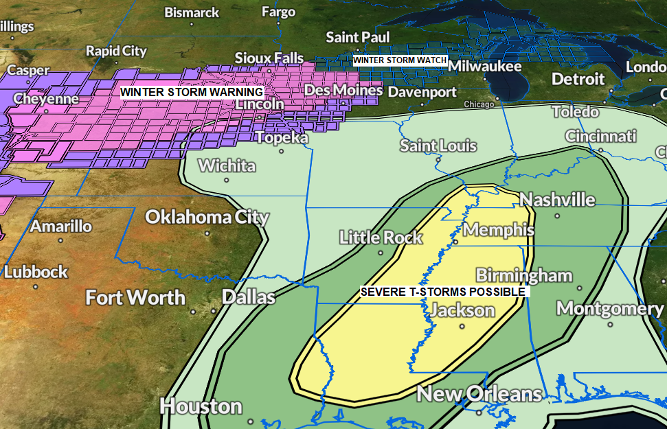
This same system producing the snow on Wednesday and Thursday will also produce some severe weather including a risk for a few tornadoes farther south from the Lower Ohio Valley to Lower Mississippi Valley on Wednesday.
Winter Weather Alerts as of late Tuesday afternoon

Storm Track and area at greatest risk for 6″+ snow totals Wednesday into Thursday.

A few snow showers and patchy drizzle/freezing drizzle will linger in parts of the Northland tonight but little to no snow/ice accumulation is expected.
Looks mainly dry during the day Wednesday but as winds become east, we could see a few lake effect snow showers develop near Lake Superior during the afternoon and evening, and after that will see the northern fringes of the winter storm passing south of our area spread some light to moderate snow northward into northwest Wisconsin and far eastern Minnesota late Wednesday night with some snow continuing during the day Thursday before ending later in the afternoon, but some snow will likely persist into Thursday night in northwest Wisconsin especially along the South Shore of Lake Superior due to some lake enhanced/lake effect snow with N-NE winds blowing across Lake Superior.
Note — Breezy northeast winds and patchy blowing snow is possible near Lake Superior Wednesday evening through Thursday with wind gusts of 20 to 35 mph.
18z NAM 3km model radar forecast valid 12 PM Wednesday to 12 AM Thursday night.

Here’s my preliminary snowfall forecast for late Wednesday night through Thursday evening.
Anywhere from 2 to 7 inches of snow is possible over much of northwest Wisconsin and we could see some winter weather alerts issued for parts of northwest Wisconsin over the next 12-18 hours for the Wednesday night-Thursday time frame.
Lesser amounts of snow to the west, generally in the trace to 2-inch range and this would include the Duluth and Superior area.

Active pattern this week as one system which affected the Northland on Monday exits off to the NE into the eastern Great Lakes today while the next system crosses the central/southern Rockies this evening.
Goes-16 water vapor loop from Tuesday, January 17, 2023 (loop time ends 5:40 PM CT)


Here’s the 500mb forecast from 6 PM this evening to 6 AM Friday.

SEVERE THUNDERSTORM POTENTIAL
There is a risk for severe thunderstorms Wednesday and Wednesday night from far eastern Texas to the Lower Mississippi Valley into the Tennessee and Lower Ohio Valleys. A few tornadoes and damaging wind gusts are the primary severe weather threats.
Yellow: Slight Risk — Scattered severe storms possible
Dark Green: Marginal Risk — Isolated severe storms possible

A few inches of snow accumulated in parts of northeast and east-central Minnesota and northwest Wisconsin from Monday into Tuesday morning, but there was little to no snow in lower elevation closer to Lake Superior as temperatures were warm enough for mostly light rain and drizzle last night and this morning, pretty crazy for mid-January.

Snowfall Reports from January 16-17, 2023
Source: National Weather Service Duluth, Minnesota
8 W Hovland, MN: 6.0″
7 WSW Pine River, MN: 2.7″
2 SSW Ely, MN: 2.7″
2 W Iron Junction, MN: 2.5″
Gile, WI: 2.0″
12 N Grand Rapids, MN: 2.0″
Siren, WI: 2.0″
3 NNW Mahtowa, MN: 1.9″
Duluth, MN: 1.7″ (official total at the NWS)
1 SSE Cornucopia, WI: 1.7″
3 N Amnicon Falls State Park, WI: 1.5″
3 E Payne, MN: 1.3″
TEMPERATURE TRENDS FOR NEXT WEEK
Note — There is a chance that we could see subzero temperatures in Duluth for the first time this month by later next week (after January 25)
Still seeing differences between the EPS and GEFS models when it comes to temperatures next week with the EPS model showing mild temps to start next week followed by colder risks mid to late next week, while the GEFS model is colder for the entire week.
EPS model temperature anomaly for January 23-28, 2023
Above average temperatures: Orange, Red and White
Below average temperatures: Blue, Green and Purple

GEFS model temperature anomaly trend for January 23-28, 2023
Below average temperatures: Blue and Purple
Above average temperatures: Orange and Red

Thanks for reading!
Tim
Leave a Reply