6:09 PM Wednesday, February 15, 2023
A mostly dry but chilly next few days ahead in the Northland but there should be quite a bit of sun especially on Thursday. Lows tonight and Thursday night will range from the teens below zero to the single digits above zero with highs Thursday in the teens to around 20 degrees.
A clipper parade starts this weekend and continues into early next week, but milder temperatures will also return with highs in the mid 20s to mid 30s both Saturday and Sunday but along with the milder temps comes the risk for a little snow in parts of the Northland this weekend into early next week. The system next Monday-early Tuesday may pack a little more punch with a narrow area of a few inches of snow possible, but there is uncertainty on the track of that system.
Mid to late next week continues to look interesting but with this being about a week out things could change compared to what the computer models are showing at the moment.
Precipitation is running above average in Duluth so far this month, but snowfall is running below average. 1.04 inches of precipitation so far this month which is +0.47″ above normal to date, while the snowfall total of 3.0 inches is -4.5 inches below normal to date.
MRMS 24-Hour Precipitation Analysis ending 8 AM Wednesday, February 15, 2023.

Precipitation Totals from February 14-15, 2023
Source: National Weather Service Duluth, Minnesota
14.8 S Superior, WI: 1.24″
Webb Lake, WI: 1.18″
1 ENE Maple, WI: 1.16″
2 E Poplar, WI: 1.14″
6.6 NW Grand Marais, MN: 1.14″
Byfield, WI: 1.13″
7.4 NNE Duluth, MN: 1.12″
1.7 SW Bayfield, WI: 1.12″
2.1 NW Two Harbors, MN: 1.11″
0.7 SSW Pine City, MN: 1.09″
1.2 W Solon Springs, WI: 1.09″
5.7 E Askov, MN: 1.04″
French River, MN: 1.04″
4.9 NE Tofte, MN: 1.01″
Shell Lake, WI: 1.01″
Grand Marais, MN: 0.98″
Washburn, WI: 0.93″
Wrenshall, MN: 0.92″
1 W Silver Bay, MN: 0.91″
Two Harbors, MN: 0.88″
Moose Lake, MN: 0.86″
2 S Tower, MN: 0.85″
Esko, MN: 0.83″
Duluth Airport: 0.83″
Siren, WI: 0.83″
Glidden, WI: 0.82″
1 SW Hayward, WI: 0.80″
Floodwood, MN: 0.79″
2 E Celina, MN: 0.78″
Embarrass, MN: 0.70″
4 W Clam Lake, WI: 0.68″
Butternut, WI: 0.67″
Brimson, MN: 0.62″
3 E Wright, MN: 0.59″
3 S Ashland, WI: 0.54″
Cook, MN: 0.51″
Cass Lake, MN: 0.50″
Hurley, WI: 0.50″
12 N Grand Rapids, MN: 0.50″
International Falls, MN: 0.36″
24-Hour Snowfall Analysis ending Wednesday, February 15, 2023, at 6 AM.
Snowfall totals late last night/this morning ranged from 2.8 inches at International Falls to 0.8 inches at the Duluth Airport.

Lower 48 Temperature Anomaly for February 2023 thru the 14th
Orange, Red and White: Above average temperatures
Blue, Green and Purple: Below average temperatures

| Average Temperature and Departure from Normal for February 2023 (thru the 14th) Ashland, WI: 20.9 F, +5.9 degrees above average Duluth, MN: 18.4 F, +5.3 degrees above average Brainerd, MN: 18.1 F, +5.2 degrees above average International Falls, MN: 14.8 F, +7.8 degrees above average Hibbing, MN: 13.6 F, +5.6 degrees above average |
COLDER AND POTENTIALLY SNOWIER RISKS NEXT WEEK
Winter appears to be making a strong comeback next week as the pattern really undergoes some major changes.
A large and widespread trough is forecast to setup from central and western Canada into the western U.S. while a ridge builds north across the southern/eastern U.S. This type of pattern can sometimes lead to either overrunning precipitation events and or larger scale low pressure systems moving out of the western U.S., or a combination of both things.
The pattern for next week certainly has the potential to turn pretty active depending on how everything sets up.

Widespread arctic air covers much of Canada into the Northern Rockies and Northern Plains, and possibly into portions of the upper Midwest for next week.

GEFS model temperature anomaly trend for February 20-25, 2023.
Blues and Purples: Below average temperatures
Orange and Reds: Above average temperatures

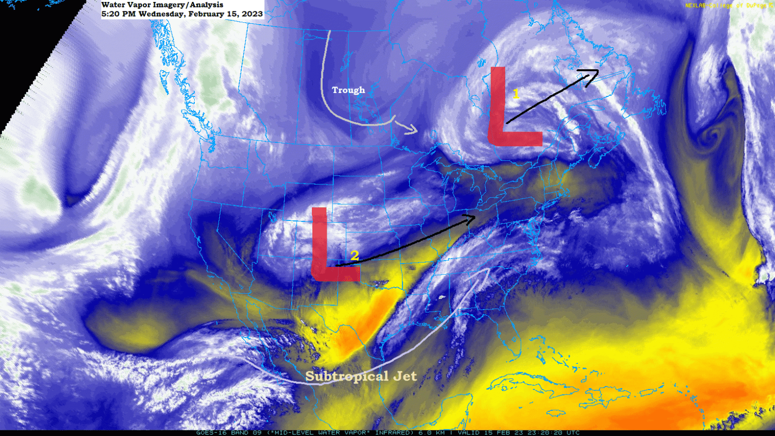
Southern Plains craziness
Extreme weather in Texas today.
Heavy snow with temperatures in the 20s in the Panhandle (north of Amarillo), while temperatures are in the low to mid 90s in parts of southwest Texas this afternoon.

Check out this temperature contrast today!
-13 degrees in parts of central Canada to the 90s in southwest Texas. The battle between winter and spring has begun.

Dust storm ripping east through portions of west Texas this afternoon while cumulus clouds are racing north in a warm and muggy and unstable air mass farther to the east.

Visible satellite loop of the image above — Loop time ends 4:51 PM CT, Wednesday, February 15, 2023.

Dryline on full display in Texas today with dew points in the 60s ahead of the dryline with single digits and teens behind the dryline.

SEVERE WEATHER POTENTIAL
An active stretch of severe thunderstorms ahead which begins tonight with a threat for severe weather across the Mid-South and lower Mississippi Valley.
Numerous severe thunderstorms possible in the Enhanced Risk, with scattered severe storms possible in the Slight Risk.

A few tornadoes are possible tonight with a strong tornado possible over parts of eastern Arkansas, northwest Mississippi into southwest Tennessee late tonight.

Risk for severe storms continues on Thursday and stretches as far north as Indiana and Ohio!
Numerous severe storms possible in the Enhanced Risk area, with scattered severe storms possible in the slight risk area.

This storm will also have a colder/snowier side north of the low through Thursday with winter weather alerts in effect stretching from New Mexico and Colorado to Lower Michigan.


Thanks for reading!
Tim
Leave a Reply