5:58 PM Thursday, February 16, 2023
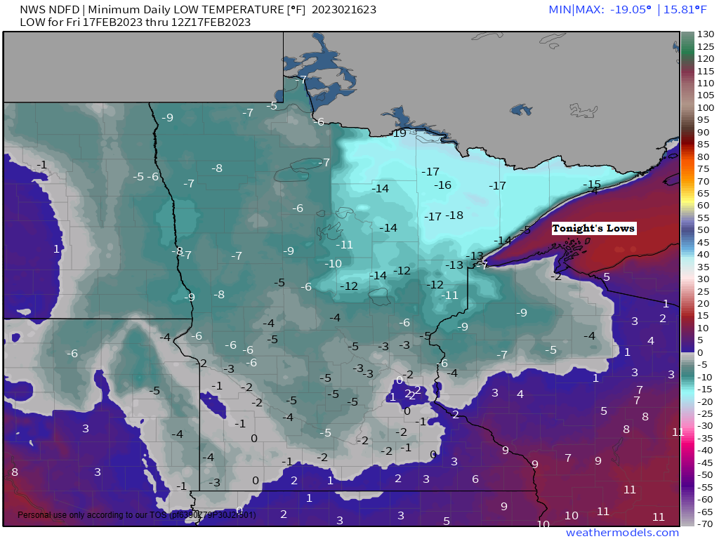
It’s going to be a very cold night across the Northland with low temperatures ranging from around -5 to -25 degrees, but this will be a brief shot of arctic air as temperatures modify this weekend, but arctic air makes a comeback next week with subzero lows possible on some nights next week.
Seasonable temperatures on Friday with highs in the 20s, and then will see temperatures climb above normal this weekend with highs in the low to mid 30s before colder air moves in for next week.
WILD PATTERN NEXT WEEK
The pattern will undergo some major changes next week as a massive summer-like ridge with 500mb heights approaching 597 decameters builds north into the southeast U.S. while big-time troughing sets up across the western U.S.
Next week’s pattern supports either several overrunning type precipitation events and or a stronger single storm system moving east-northeast out of the Rockies.
The pattern for next week does have potential to be very active across parts of the upper Midwest with significant snowfall and ice accumulations possible. Stay tuned.

A very tight pressure gradient has been forecasted for a few days now across the upper Midwest for the middle of next week.
Winds look to be out of the east or northeast and could be quite strong near Lake Superior where wind gusts of 30 to 40+ mph are possible for next Wednesday and Thursday.
Note — If we do get some snow near Lake Superior the middle of next week then blowing snow could become a big issue due to the potential for strong winds.

A major clash in temperatures setting up for the middle of next week.

The ridge over the southeast U.S. and the trough over the western U.S. will help draw warm/humid air northward out of the Gulf of Mexico, and this warm/humid air mass will run into much colder air which will be in place over the upper Midwest and Great Lakes next week.
Meanwhile there will be widespread dry/arctic air sitting a little farther to the west/north next week.
The battle will be on between how far north the moisture will get, and how far south that much drier air sets up for the middle to end of next week.

A few clippers pass through the area this weekend but none of them look very strong at the moment with only light dustings of snow possible mainly in northern Minnesota Saturday and again on Sunday.
A stronger clipper could impact portions of the Northland next Monday with a shot for a few inches of snow Monday into early Tuesday.

An area of low pressure is moving northeast across the Ohio Valley today while high pressure builds southeast out of eastern North Dakota.

The low over the Ohio Valley has been producing widespread snow and some freezing rain northwest of the low, while rain and thunderstorms are occurring in the warmer air near and south of the low today.

MRMS radar snapshot of today’s system.
Snow (blue)
Rain (green)
Mix Precipitation (pink)

Here’s the colder/snowy side of today’s system. Note the lumpier (oatmeal like) appearance in the clouds over southern/eastern Wisconsin and over Lake Michigan which represents some heavier convective like snow bursts today.
Goes-16 visible satellite loop ending 4:11 PM CT, Thursday, February 16, 2023.

There’s been several reports of 5-8″ of snow today from southeast Nebraska into southern Iowa to southern Wisconsin.

Here’s the warmer side of today’s storm where showers and thunderstorms have been occurring today with reports of flooding, hail and damaging winds including 3 preliminary tornado reports in Mississippi today.
Around 40 filtered severe weather reports on Wednesday mostly over the eastern half of Oklahoma, southern Missouri into northern Arkansas, and 12 filtered severe weather reports so far today (thru 4 PM CT)
Infrared satellite loop from Thursday, February 16, 2023 (loop time ends 4:16 PM CT)

Temperatures range from the -20s around Hudson Bay Canada to the 70s and 80s over the southeast U.S. today.

Thanks for reading!
Tim
Leave a Reply