7:18 PM Sunday, February 26, 2023
A complicated forecast ahead Monday
-Computer models have been showing some pretty large shifts on where the greatest precipitation amounts setup for Monday with last night’s model runs shifting things farther west/north, while today’s model runs have been trending more to the east.
-Parts of northwest Wisconsin and possibly far eastern Minnesota look to be the area at highest risk for getting the most precipitation on Monday with lesser amounts of precipitation expected in northern Minnesota including for the Twin Ports.
-The threat for ice accumulations from freezing rain is highest from parts of east-central Minnesota to northwest Wisconsin (south of Duluth), with a light glaze of ice possible on Monday a little farther north including in the Twin Ports.
-Snowfall amounts on Monday have decreased compared to 24 hours ago.
-The Arrowhead and portions of the North Shore of Lake Superior, south into parts of northern Wisconsin including the Bayfield Peninsula look to get the bulk of the higher snow accumulations on Monday with total snow accumulations of 2 to 4 inches possible in those areas with slightly higher snow totals possible along the North Shore of Lake Superior where some lake enhanced snow is possible due to easterly winds on Monday.
-Snowfall accumulations of a trace to 1 inch are possible in Duluth on Monday, this is down from my forecast of 3 to 5 inches on Saturday for Monday’s event.
Here is my updated snowfall forecast for Monday.

Some sleet or freezing rain is possible in Duluth on Monday with a light glaze of ice possible, but a more significant amount of ice from freezing rain is expected south of the Twin Ports on Monday, including areas of east-central Minnesota into northwest Wisconsin.
Shown below is the Euro model ice accumulation forecast through 6 PM Monday.
Black outlined area on map represents ice accumulations of 0.05″ to 0.25″ or greater.

For Duluth — Some light freezing rain and sleet is possible Monday morning beginning between 4 and 7 AM. A light glaze of ice accumulation is possible. Precipitation changes to some snow late Monday morning/early Monday afternoon with total snowfall accumulations of up to 1″. Precipitation ends late Monday afternoon/early Monday evening. It will be blustery on Monday with easterly winds gusting 15 to 30 mph in the Twin Ports.
18z NAM 3km model radar forecast valid from Midnight tonight to Midnight tomorrow night.
Snow (blue)
Mix precipitation (pink and purple)

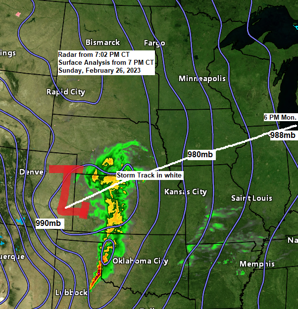
The system which will impact parts of the upper Midwest late tonight and Monday is currently moving northeast into the central Plains early this evening.
Goes-16 infrared satellite loop ending 6:26 PM CT, Sunday, February 26, 2023.

Goes-16 water vapor loop ending 6:26 PM CT, Sunday, February 26, 2023

Severe weather is occurring ahead of this system tonight with tornado and severe thunderstorm watches covering parts of southwest Kansas, western Oklahoma and the northwest/eastern Texas Panhandle.
So far there’s been about 20 reports of severe weather stretching from southwest Kansas to the northern Texas Panhandle today (thru 6 PM CT) with 1 tornado reported in southwest Kansas, along with wind gusts of up to 80 mph.

Thanks for reading!
Tim
Leave a Reply