6:40 PM Tuesday, March 28, 2023
Here we go again.
-Active times ahead with several systems possibly impacting the Northland through next week.
-Snow showers come to an end later tonight with a cold but mostly sunny Wednesday ahead.
-Snow or a mix of snow, sleet and freezing rain on the way for Thursday afternoon-early Friday morning, and there is even a chance for an isolated thunderstorm in eastern Minnesota and northern Wisconsin.
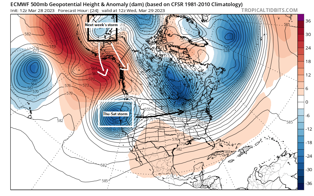
-A second wave of snow or a wintry mix is possible Friday afternoon-early Saturday morning, but computer models remain in disagreement on how far north this system will track, with the GFS model the farthest north with a significant winter storm impacting much of the Northland, while the Euro continues to be a complete miss to the south.
-Another storm is brewing for some time next week which could bring more snow, rain or a mix to the Northland depending on the storm track.
A warm advection driven snow and mixed precipitation event is forecast to impact the Northland Thursday afternoon into early Friday morning with precipitation developing mid to late afternoon on Thursday (after 1 PM) with precipitation diminishing early Friday morning the way it looks now.
European model radar forecast valid from 1 PM Thursday to 7 AM Friday.
Snow (blue)
Wintry Mix (orange and pink)
Rain (green)

Here’s my preliminary snowfall forecast for Thursday night’s event.
Duluth: 2 to 4 inches of snow is possible from late Thursday afternoon through early Friday morning.

Along with the chance for some snow accumulation will be the risk for some ice accumulations over southern portions of the Northland (outlined in black) Thursday evening/overnight with a chance for up to 0.05 inches of ice accumulation.
Note — There is uncertainty on how far north the warmer air aloft gets for Thursday night and this will determine whether or not precipitation falls as snow, or changes over to some sleet/freezing rain. At the moment it looks like the highest chances for some sleet and freezing rain will be south of Highway 2 in northeast Minnesota including all of northwest Wisconsin, this is where 850mb temperatures could warm to around +1 to +3C Thursday night while surface temps remain below freezing.

Record Cold tonight?
Temperatures will be on the cold side tonight with lows in our area ranging from -10 to +10 degrees (normal lows on March 29th range from the upper teens to middle 20s)
Record lows for March 29th
International Falls, MN: -11 set in 1969
Duluth, MN: -9 set in 1969
Hibbing, MN: -9 set in 1969
Ashland, WI: -1 set in 1969
Brainerd, MN: 2 set in 1944 and 1954
Note — Brainerd probably has the greatest chance at setting a new record low temperature tomorrow morning.

First 50 of 2023 in Duluth on Sunday?
Computer models aren’t in the best agreement for late this weekend, but the European model is all in on a mild Sunday around here with a chance for 50-degree temps Sunday afternoon in parts of the Northland. I’ll be watching model trends closely.

A powerful low-pressure system just offshore from the Pacific northwest will dig SE into California on Wednesday before moving quickly to the east through the central Rockies and Midwest from Thursday into Friday. Here’s a look at this system on Goes-16 Day Cloud Phase satellite imagery from Tuesday, March 28, 2023 (loop time ends 3:56 PM CT)

And a visible satellite loop of this powerful low from today (loop time ends 3:56 PM CT)

As the aforementioned system moves out into the Plains will see the potential for severe thunderstorms increase late this week, especially on Friday with widespread severe thunderstorms possible stretching from southern Wisconsin to northeast Texas with highest probabilities for severe weather in the orange area on the map below.
All severe weather hazards are in play on Friday including large hail, damaging winds and some tornadoes.

A zoomed in look on the severe thunderstorm risk centered on Wisconsin for Friday — The risk area covers far southern portions of the state (yellow area on map)

Tim
Leave a Reply