7:48 PM Wednesday, March 29, 2023
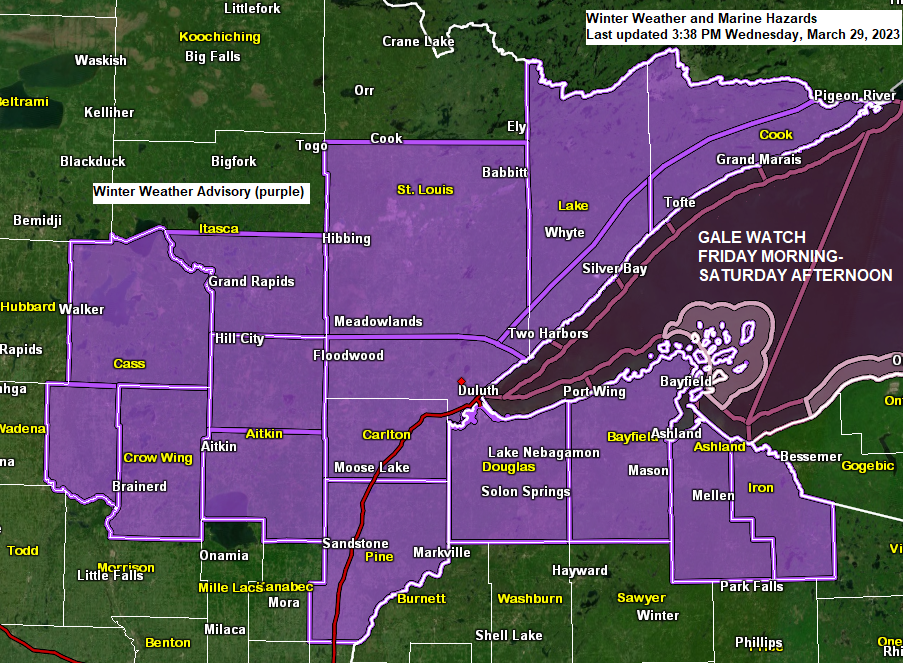
The weather will remain on the quiet side in the Northland tonight through early Thursday afternoon but after that we should begin to see some snow develop while moving northeast across southern portions of the Northland, this should occur by mid to late afternoon on Thursday.
Snow is forecast to continue Thursday night while also spreading farther north.
Warmer air aloft moving into eastern Minnesota and northwest Wisconsin will cause the snow to change to either freezing rain or sleet Thursday night through Friday morning. The icing potential is highest south of Highway 2 in northeast Minnesota including all of northwest Wisconsin.
Back to tonight for a moment, it’ll be another cold one with lows ranging from around -10 to +10 degrees in the Northland.
Record Low Temperatures for March 30th
Brainerd, MN: -13 set in 1975
International Falls, MN: -13 set in 1975
Duluth, MN: -12 set in 1923
Hibbing, MN: -12 set in 1975
Ashland, WI: -7 set in 1923
Here’s my updated snowfall forecast for Thursday evening through early Friday morning.
For Duluth: 2 to 4 inches of snow is possible Thursday night. Snow is forecast to start between 4 PM and 8 PM Thursday in Duluth with snow ending early Friday morning between 4 AM and 7 AM.

There are differences in the computer models on the amount of warm air that moves north into our area Thursday night, and this will determine what areas see some freezing rain or sleet.
The NWS Blend of Models shows some ice accumulations much farther north compared to the Euro model which is farther to the south.
NWS Blend of models

Euro model

A strong area of low pressure over northwest Kansas around 7 PM Thursday tracks across central Iowa Friday, then reaches Lake Huron around daybreak on Saturday. This storm track should keep the corridor of highest snow totals mostly south of the Northland for Friday afternoon through early Saturday morning.

Northeast winds are forecast to increase across the Northland on Friday and will be strongest near Lake Superior where wind gusts of 35 to 45 mph are possible Friday afternoon through early Saturday morning.
Euro model wind gust forecast valid 7 AM Friday to 7 AM Saturday.

Probability for thunder valid 7 PM Thursday to 1 AM Saturday.
Note — Higher probs for thunder in green and blue colors on the loop below.
NWS Blend of Models

Low pressure passing just south of Minnesota on Friday will be a strong one averaging around -2.5 sigma while the central pressure of the surface low drops into the 980s millibar range.

What a powerful storm moving into California this afternoon as seen on Goes-16 water vapor imagery (loop time ends 4:20 PM CT, Wednesday, March 29, 2023)
This is the same storm which will move quickly to the ENE over the next few days reaching Lake Huron around daybreak on Saturday.

Top 5 greatest snow depths on record at Duluth, Minnesota for April 1.
1: 41 inches set in 1965
2: 32 inches set in 1975
3: 27 inches set in 2014
4: 27 inches set in 1956
5: 24 inches set in 1951
Note: There is a good chance that will have the 2nd greatest snow depth on record in Duluth for April 1 with a snow depth currently sitting at 32 inches as of 7 AM, March 29. Only 18% of years had a snow depth of greater than 12 inches on April 1st dating back to 1948, although snow depth records for Duluth go back to 1872 but there are several years with missing data for snow depths until you get to 1948 and beyond.
A new record low temperature was set for March 29th at Brainerd, Minnesota this morning with a low of -10 degrees, this breaks the previous record low temperature for the date of 2 degrees set in 1944 and 1954.
Low Temperature Reports from Wednesday morning, March 29, 2023
Source: National Weather Service Duluth, Minnesota
Brainerd, MN: -10
Crane Lake, MN: -8
Longville, MN: -8
Pine River, MN: -6
Orr, MN: -4
International Falls, MN: -2
Hibbing, MN: -2
Cook, MN: -2
Eveleth, MN: -2
Aitkin, MN: -2
Walker, MN: -1
Ely, MN: 0
Duluth Airport: 2
Darker blue dots on the animation below represents locations either tying or breaking daily record low temperatures over the past 24 hours ending at 11 AM CT, Wednesday, March 29, 2023.

Widespread severe thunderstorms are possible on Friday from extreme southern Minnesota and southern Wisconsin south to northeast Texas, then all the way east to northern Alabama and western Ohio.
The highest probability for severe weather includes the area in orange on the map below.
All severe hazards are in play on Friday including damaging winds, some tornadoes and large hail.

Zoomed in view of the severe risk in Minnesota for Friday, March 31, 2023.
Far southern areas of the state are in a marginal (dark green) and slight (yellow) risk for isolated to scattered severe storms, this would include the Albert Lea, Owatonna and Rochester areas.

Zoomed in view of the severe risk in Wisconsin for Friday, March 31, 2023.
An enhanced risk for severe thunderstorms (orange) for far southwest Wisconsin with numerous severe thunderstorms possible.
Marginal (dark green) and slight (yellow) risk for severe thunderstorms for the rest of south-central Wisconsin for Friday.

Tim
Leave a Reply