6:04 PM Thursday, March 30, 2023
A powerful spring/winter storm will impact a large portion of the northern Plains and upper Midwest east to the Great Lakes and south into parts of the Midwest over the next 36 hours.
Most of the snow or mixed precipitation we see in the Northland out of this system will occur tonight into early Friday morning, with only far southern portions of the area (south of Duluth) possibly seeing another round of snow Friday afternoon/night the way it looks as of late Thursday afternoon.
Some snow and a mix of snow, sleet and freezing rain is likely across portions of the Northland tonight with mostly light snow accumulations of an inch or two expected through the night.
Far northern Minnesota into the Arrowhead probably won’t get any snow at all tonight.
For Duluth: Snowfall accumulations of 1 to 2 inches are possible through 7 AM Friday. Snow gradually develops this evening then tapers off Friday morning between 1 AM and 4 AM. A few more snow showers or flurries are possible during the day Friday, but no additional accumulation is expected.

As warmer air aloft surges north tonight, we should see the snow change over to some freezing rain or sleet overnight with areas of freezing rain and sleet lingering into the day Friday. The greatest risk for some ice accumulations which could reach 0.05 to as much as 0.25 inches will be over far southern portions of the Northland including parts of east central Minnesota and northwest Wisconsin or roughly south of a line from Brainerd to Moose Lake to Solon Springs to Glidden.

Here’s a look at the European model radar forecast through 7 AM Saturday.
Snow (blue)
Rain (green)
Wintry Mix (pink and orange)

Northeast winds will increase on Friday with wind gusts of 25 to 40 mph for east central Minnesota into northwest Wisconsin with gusts possibly as high as 45 to 55 mph near Lake Superior. Winds will diminish Saturday morning.
NWS Blend of Models wind gust forecast valid Midnight tonight to 7 AM Saturday.

It still looks like the greatest chances for 3 to 6 inches or more of snow will setup mostly south of the Northland Friday afternoon through early Saturday morning.

Here’s my snowfall forecast for Friday afternoon through early Saturday morning.

A variety of winter weather alerts in effect across the area.

Blizzard Warning in effect Friday through early Saturday morning for portions of northern and eastern South Dakota into far southwest Minnesota.

The system moving through the area tonight and Friday is very dynamic and will likely produce some thunderstorms in the colder air in parts of central and eastern Minnesota into west central Wisconsin, so some instances of thundersnow, thunder freezing rain or thunder sleet are likely tonight and Friday.

A very large thermal gradient will setup on Friday with 850mb temperatures ranging from around +10C in far southern Minnesota to around -7C in far northern Minnesota to -20C farther north in Ontario.

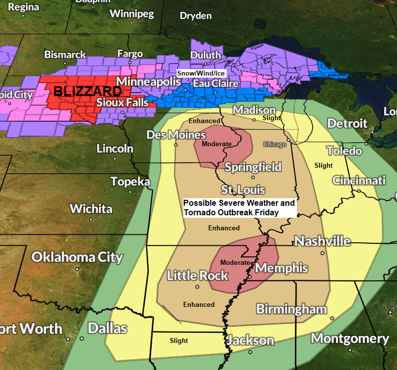
SEVERE THUNDERSTORM OUTBREAK EXPECTED ON FRIDAY
Ingredients seem to be coming together to support an outbreak of severe thunderstorms Friday across portions of the Middle Mississippi Valley and Mid-South, eastward to the Lower Ohio and Tennessee Valleys.
Strong surface and upper-level low pressure moving east out of the Rockies with moisture surging north out of the southern Plains while very strong winds in the atmosphere spread northeastward out of the southwest U.S. This combination of ingredients combined with warm, humid and unstable air should set the stage for severe thunderstorms on Friday for the areas mentioned above.

Here’s a loop of the image above — Goes 16 water vapor loop from Thursday, March 30, 2023 (loop time ends 12:50 PM CT)

Moderate Risk (level 4/5) Red
Enhanced Risk (level 3/5) Orange
Slight Risk (level 2/5) Yellow
Marginal Risk (level 1/5) Dark Green

Strong tornadoes EF2 – EF5 are possible within 25 miles of a point in the hatched areas on Friday.

Damaging Wind outlook for Friday.

Large Hail outlook for Friday.

A zoomed in view of the northern tornado risk zone for Friday. Note — An isolated tornado is even possible in extreme southeast Minnesota on Friday, but the greatest chances should remain a little farther south.

And here’s the southern tornado risk zone for Friday.

A look at where we could see rotating updrafts and possible tornadoes Friday/Friday night per HRRR and NAM3km model helicity track forecast.


Tim
Leave a Reply