8:22 PM Tuesday, April 11, 2023
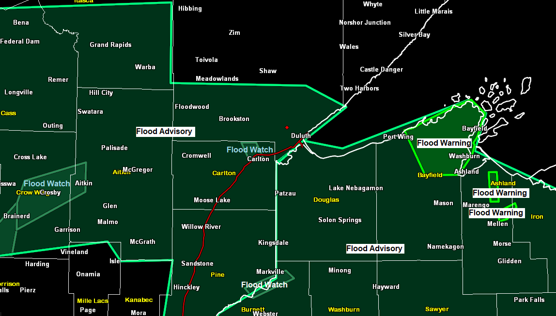
Flood Headline information — Source, National Weather Service Duluth, Minnesota.
Flood Warnings issued for parts of northwest Wisconsin
*Flood Warning for snowmelt until 4:15 PM Thursday for a portion of northwest Wisconsin including Bayfield.
-Flooding of rivers, creeks, streams, and other low-lying and flood-prone locations is imminent or occurring.
-At 4:31 PM, emergency management reported rapid snowmelt in the warned area. Flooding is ongoing or expected to begin shortly.
-This includes the following streams and drainages…Raspberry River, Sioux River, Pikes Creek, Whittlesey Creek, Sand River, Siskiwit River, Cranberry River, Red Cliff Creek, Thompson Creek, Little Sioux River, Pine Creek, North Fish Creek, Little Pine Creek, Onion River. Some locations that will experience flooding include Washburn, Barksdale, Bayfield, Cornucopia, Sand Bay, Herbster, Red Cliff, the Tribal Lands of the Red Cliff Reservation.
*Flood Warning for the following rivers in Wisconsin
-Bad River near Odanah affecting Ashland County.
-Warm temperatures will melt snowpack and increase river flows.
-Minor flooding is forecast.
-This flood warning is in effect from Thursday evening until further notice.
-At 5:45 PM Tuesday, the stage was 10.7 feet. Flood stage is 16 feet.
-The river is expected to rise above flood stage Thursday evening to a crest of 17.0 feet Friday evening. It will then fall below flood stage early Sunday morning.
-Flood history, this crest compared to a previous crest of 15.3 feet on June 18, 2018.
-Impacts, at 15.0 feet, several roads including Miller Road, Government Road and State Road may be flooded at this stage.
-At 18.0 feet, water approaches the level of Highway 2 near Odanah.

*Flood Warning for the Bad River at Odanah affecting Ashland County
-This flood warning is in effect from Thursday afternoon until further notice.
-Minor flooding is forecast.
-At 5 PM Tuesday, the stage was 6.9 feet, flood stage is 8.5 feet.
-The river is expected to rise above flood stage Thursday afternoon to a crest of 9.0 feet Friday evening. It will then fall below flood stage Sunday evening.
-Impacts, at 8.5 feet minor flooding begins as water encroaches on State Street through the Sugar Bush. At 9.0 feet, many roads and several homes are impacted by flood waters in the Old Odanah area. Government Road south of US Highway 2, Miller Road and State Road will see areas of water flowing over the roadway.

*Flood Warning for the Tyler Forks River at Strickler Road near Mellen
-This flood warning is in effect until further notice.
-Major flooding is forecast.
-At 6:30 PM Tuesday, the stage was 8.8 feet. Flood stage is 9.0 feet.
-The river is expected to rise above flood stage late this evening to a crest of 12.5 feet early Friday afternoon. It will then fall below flood stage Monday afternoon.
-Impacts, at 9.8 feet, at this level St Hwy 169 is likely impacted by flood water. At 11.9 feet, water over State Hwy 169. 1.25 miles upstream from TYLW3 location.
-Flood history, this crest compares to a previous crest of 12.2 feet on June 16, 2018.

*Flood Watch for the following rivers in Minnesota
-Mississippi River at Fort Ripley affecting Crow Wing County.
-Flooding is possible.
-This flood watch is in effect from Monday afternoon until further notice.
-At 5:30 PM Tuesday, the stage was 6.2 feet. Flood stage is 10.5 feet. Flood stage may be reached early Monday afternoon.

*Flood Watch for the Mississippi River at Aitkin
-This flood watch is in effect from Saturday afternoon until further notice.
-Flooding is possible.
-At 5:30 PM Tuesday, the stage was 9.7 feet. Flood stage is 13.0 feet. Flood stage may be reached early Saturday afternoon.

*Flood Watch for the following rivers in northwest Wisconsin and eastern Minnesota
-St. Croix River at Danbury affecting Burnett and Pine Counties.
-This flood watch is in effect from late Thursday night until further notice.
-Flooding is possible.
-At 5 PM Tuesday, the stage was 3.9 feet. Flood stage is 7.0 feet. Flood stage may be reached early Friday morning.

*Flood Watch for the St. Louis River at Scanlon affecting Carlton and South St. Louis Counties in Minnesota
-This flood watch is in effect from Saturday afternoon until further notice.
-Flooding is possible.
-At 6:30 PM Tuesday, the stage was 4.7 feet. Flood stage is 10.5 feet. Flood stage may be reached Saturday afternoon.

Another very warm mid-April day across the Northland
High temperature reports from Tuesday, April 11, 2023
Siren, WI: 76
Hayward, WI: 73
International Falls, MN: 71 (record high 75 set in 1955 and 1968)
Superior, WI: 71
Solon Springs, WI: 70
Ashland, WI: 70
Duluth Sky Harbor Airport: 70
Ely, MN: 70
Orr, MN: 70
Brainerd, MN: 69
Moose Lake, MN: 68
Hinckley, MN: 68
McGregor, MN: 68
Cloquet, MN: 66
Hibbing, MN: 66
Duluth Airport: 66
Two Harbors, MN: 66
Aitkin, MN: 66
Walker, MN: 65
Bigfork, MN: 64
Grand Rapids, MN: 64
Note — Snow depth at the Duluth Airport has dropped over a foot since Sunday. Snow depth on Sunday, April 9 was 27 inches. Snow depth as of 4 PM Tuesday, April 11 was down to 13 inches.
Wednesday will likely be the warmest day of the week with highs ranging from the mid 60s to mid 70s in northeast Minnesota and northwest Wisconsin with near 80 degree temperatures possible around the Siren and Hayward areas in northwest Wisconsin, while southern Minnesota warms to the low and even mid 80s Wednesday.

This ridge which covers the Rockies, northern Plains and upper Midwest is massive with 500mb heights topping out at around 584 decameters today, while 850mb temperatures peak at around +18 to +27C which is very impressive for mid-April.
It’s no surprise we saw some 90s in parts of South Dakota for highs today, with 80s in parts of southern Minnesota given the strength of this upper ridge.

Dry weather continues on Wednesday, but rain chances increase Thursday into Friday mostly in northern Minnesota with mainly dry weather lingering in eastern Minnesota and northwest Wisconsin through Friday, with rain chances then increasing in those aforementioned areas this weekend.
Here’s a look at the NWS blend of models total precipitation thru 7 AM Monday.

There is still a chance that will see some snow in parts of the Northland this weekend, mainly in the Saturday night to Monday time frame, but there continues to be a lot of uncertainty in the computer models on how this system evolves and just how much snow could fall/accumulate in the Northland later this weekend. Stay tuned.
Here’s the 18z GEFS 20-member model snowfall forecast thru 7 AM Monday.
Blue colors: 2″+ snowfall
Purple colors: 6″+ snowfall

It’s a complex setup this weekend with the potential for an upper-level trough to slow down and become negatively tilted while low pressure deepens over the Great Lakes. We could see at least some moisture push NW out of Wisconsin and into parts of the Northland late this weekend, and if that happens and there is enough cold air available, then we could see some snow.

Tim
Leave a Reply