6:24 PM Wednesday, April 19, 2023
A messy winter/spring storm will impact the Northland beginning late tonight and lingering into early Friday morning. Will there be a surprise or two with this storm? There could be, in that snow and or ice accumulations could end up higher than what is being forecast in northeast Minnesota this afternoon for this event. These late season winter systems are very tricky as we don’t have the supply of cold air like we had as recent as a month ago, but these spring systems can make their own cold air by way of heavy precipitation rates causing dynamic cooling processes to occur which can cause rain to switch over to heavy thick wet snow at times which can lead to rapid snowfall accumulations. We also have Lake Superior to deal with and with winds coming off that lake there is a chance that enough cold air will lock into place with temperatures holding around 30 to 32 degrees near the lake, and if that happens, then there is a chance for more significant snow and or ice accumulations including in Duluth. Bottom line is that even at this late hour as this system approaches there is a great deal of uncertainty regarding snow/ice accumulations in northeastern Minnesota including in the Duluth area.
Note — Additional snow showers (and possible snow squalls) mixed with rain at times will likely linger across the Northland on Friday and possibly even into Saturday as a large and slow moving upper-level low lingers over the upper Midwest and western Great Lakes.
SNOWFALL FORECAST — UPDATED
I did make a change or two to my original snowfall forecast from Tuesday, but overall, not too many changes.
Note — Duluth only needs 0.4 inches of snow to break the season snowfall record of 135.4 inches set in 1995-1996. There’s a pretty good chance will get enough snow to break that record by Friday morning, but then again, I thought the same thing on Sunday and that was a swing and a miss.
Duluth area: 1 to 3 inches of total snowfall accumulation thru 7 AM Friday, with the higher amounts of snow on top of the hill.

FREEZING RAIN/ICE ACCUMULATION POTENTIAL
With temperatures above freezing (0C) a few thousand feet in the atmosphere this does open up the possibility for some freezing rain and ice accumulations in parts of the Northland assuming temperatures at the surface are cold enough for the rain to freeze on contact, and temperatures although a little marginal for significant ice accumulations are cold enough to support some icing with temps forecast to range from around 31 to 33 degrees on Thursday.
If we do get some freezing rain, the greatest impacts in terms of ice accumulations may end up being on higher elevated surfaces including trees and powerlines with lesser impacts on roads especially treated ones given the time of year and marginal temperatures.
The risk of freezing rain/icing is greatest 10 to 20 miles inland from Lake Superior in northeast Minnesota including higher elevation areas. Locations closer to Lake Superior should be just warm enough to prevent much ice accumulations from freezing rain late tonight through Thursday, but sleet could be an issue close to Lake Superior which could lead to slushy roads at times.

Note — There is a possibility that we could see an upgrade to an ICE STORM WARNING for areas in and close to Duluth should these model forecasts verify, but I’m hesitant to buy into these significant amounts of ice accumulations the models below are showing. A lot of that has to do with the marginal surface temperatures during this event, and also because of the time of year, but will see what happens.
It’s also possible will see some parts of the Winter Weather Advisory upgraded to a WINTER STORM WARNING.
Euro model continues to be pretty aggressive with ice accumulations, but this model was also aggressive with ice accumulations a few weeks back and that really didn’t verify well in most of the Northland.
Duluth: 0.23″ of total ice per Euro forecast.

EPS model or Euro ensemble total ice for Duluth ranges from nothing on the low-end to a high-end amount of 0.35″.

NWS Blend of Models shows an ice accumulation of 0.17″ in Duluth with localized greater amounts of 0.25″ or more.

Duluth area: Precipitation begins late tonight (after 11 PM) with all precipitation types likely, ranging from wet snow, sleet/ice pellets, rain and some freezing rain. This precipitation will continue thru Thursday evening with heavy precipitation rates possible at times.
NAM 3km model radar forecast thru 7 AM Friday.
Snow (blue)
Wintry Mix (pink and purple)
Rain (green)

Winter Weather Advisories are in effect from late tonight through early Friday morning for northern and northeastern Minnesota.

STRONG WINDS NEAR LAKE SUPERIOR
East to northeast winds of 25 to 45 mph will be found near Lake Superior and Twin Ports tonight through Thursday evening with wind gusts of 50 to 60 mph possible during the day Thursday into Thursday evening. Winds will diminish by late Thursday night.
Euro model wind gust forecast valid 7 PM Wednesday to 1 AM Thursday.

Widespread precipitation totals of 0.50 to 1″ or more are expected in northeast Minnesota and northwest Wisconsin from tonight thru early Friday morning.

HEAVY RAIN THREAT
Rain could lead to isolated instances of flash flooding tonight in much of northwest Wisconsin and in far eastern Minnesota.

Much of northwest Wisconsin remains in a marginal risk for flash flooding during the day Thursday as well due to the potential for more rain and heavy downpours.

FLOODING
Flood Warnings remain in effect in parts of the Northland (green outlined areas on map) and a Flood Advisory is also in effect across the Northland.

Winter to the north with spring to the south, it’s the classic battle between the two seasons!

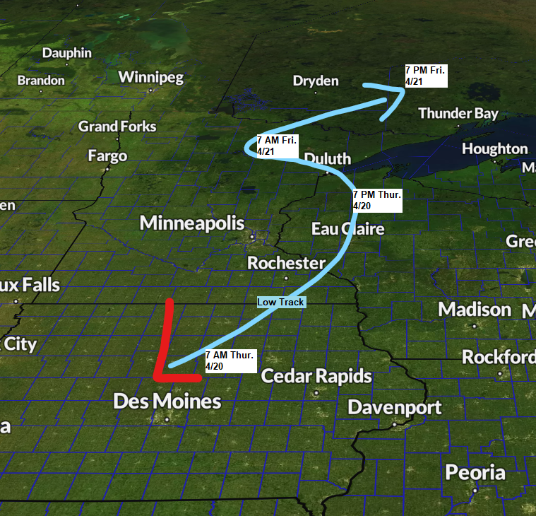
Here’s a look at the developing storm which will impact the Northland over the next few days.
The original system is over eastern Montana/western North Dakota this afternoon but a secondary low is developing over the Central Plains, and that will become the main system from here on out as it lifts north into the upper Midwest over the next 24 hours.
Goes-16 infrared satellite loop from Wednesday, April 19, 2023 (loop time ends 5:05 PM CT)

Tim
Leave a Reply