6:09 PM Tuesday, May 16, 2023
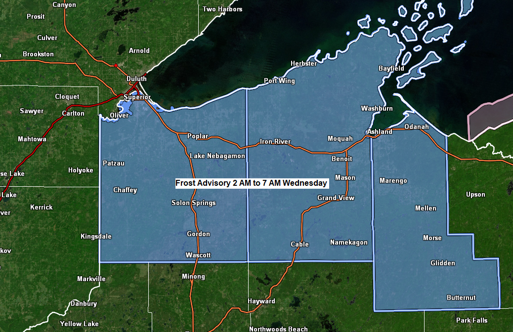
Frost Advisory in effect from 2 AM to 7 AM Wednesday for parts of northwest Wisconsin including the cities of Superior, Solon Springs, Gordon, Iron River, Cable, Mason, Washburn, Bayfield, Ashland, Mellen, Glidden and Butternut. Temperatures as low as 34 will result in frost formation.
The high at the Duluth Airport today was 69 degrees which occurred at 9:26 AM this morning, then a strong cold front moved through, and winds shifted to the northeast which caused the temperature to drop into the 50s (even lower closer to Lake Superior) this afternoon.
It will be a chilly night tonight with lows in the 30s to lower 40s with even a few 20s possible in the traditional cold spots inland from Lake Superior.
East wind continues Wednesday which will help keep temperatures in the 40s and 50s closer to Lake Superior with warmer temperatures in the low to mid 70s farther away from Lake Superior.
We will get a wind shift near Lake Superior for Friday and Saturday, and possibly even as soon as Thursday. Warmest day of those 3 looks to be Saturday with highs close to 70 near Lake Superior.
A strong backdoor cold front moved quickly to the west/southwest down Lake Superior and through northeast Minnesota and northwest Wisconsin today dropping temperatures a good 10 to 20 degrees in about an hour. Strong northeast winds with gusts of 30 to 40 mph also accompanied this cold frontal passage today near Lake Superior.

Temperatures near Lake Superior were running some -20 to -30 degrees colder at 4 PM today compared to 4 PM Monday thanks to a northeast wind today.

An area of low pressure with its warm front and cold front along with a strong upper-level low will be moving ESE through the Northland from Thursday into Friday. This system will bring some rain at times to the Northland late this week, but this system is fairly progressive unlike previous systems which have had a tendency to linger quite a while.
System late this week is a strong one and it should have some decent lift with it which will lead to some rain at times Thursday into at least Friday morning the way it looks now.
Here’s the NAM 500mb vorticity forecast valid 1 PM Thursday to 1 PM Friday.

Duluth area: Rain chances look highest Thursday and Thursday night with a few showers lingering into the day Friday.
NAM 3km model radar forecast valid 7 PM Wednesday to 1 AM Friday.

Rainfall totals ranging from around 0.10″ to as much as 0.75″ are possible in the Northland late this week with the higher totals favoring parts of far northern Minnesota.

The band of wildfire smoke which was over northeast Minnesota and northwest Wisconsin last evening into this morning has pushed farther to the west/south this afternoon thanks to the northeasterly winds.
Moderate air quality (yellow) continues late this afternoon in parts of western, central and southwest Minnesota with good air quality in green.

Wildfire smoke showed up nicely on visible satellite imagery today (note the milky colored appearance in western, central and southern Minnesota)
Goes-16 visible loop from Tuesday, May 16, 2023 (loop time ends 5:06 PM CT)

Fires in western Saskatchewan were showing up nicely on visible satellite imagery this afternoon.
Smoke from these fires will continue to impact the Northland at times over the next few days, but a lot of this smoke should remain aloft resulting in hazy skies but not much of a smoke smell at the surface.

Loop of the above image.

An amplified pattern continues today with a deep trough centered over central/eastern Canada into the Great Lakes and northeast U.S. with an upper-level ridge covering parts of western Canada. The upper Midwest remains firmly entrenched in a northwest flow in the mid/upper levels of the atmosphere.

Warmer signals showing up for next week, although the EPS model is running slightly cooler in northeast Minnesota and northwest Wisconsin compared to the GEFS model.
Note: Will probably be dealing with some lake breezes at times near Lake Superior next week which will keep temperatures cooler when those lake breezes occur, otherwise we’re looking at highs in the 60s and 70s next week and temperatures could be even warmer than that.
Color legend on the two images below
Orange, red and white: Above average temperatures
Blue and green: Below average temperatures
EPS model forecast

GEFS model temperature anomaly trend for May 22-27, 2023.

Tim
Leave a Reply