5:11 PM Monday, May 29, 2023
Rainfall anomalies in the Northland for May 2023 (thru 4 PM on the 29th)
Ashland, WI: -2.89″ below normal
Duluth, MN: -2.33″ below normal
Hibbing, MN: -1.79″ below normal
Brainerd, MN: -1.76″ below normal
International Falls, MN: -0.75″ below normal
It’s been a very quiet start to the thunderstorm season in the Northland, but that might change a bit the next few days as will see a more favorable environment to produce isolated to scattered showers and thunderstorms in much of the Northland.
The risk for severe thunderstorms is pretty low through the end of the week, but an isolated severe thunderstorm can’t be ruled out due to the higher amounts of instability and moisture that’ll be in place across the area, otherwise the setup favors pulse type storms where thunderstorms erupt then spit out a gust front/rain-cooled air, then the storm falls apart, and then will see the whole process start over again. This type of setup is favorable, however, for heavy rainfall where thunderstorms occur over the next few days due to rather slow storm speeds and the higher moisture content.
Storm coverage over the next few days will likely be isolated to scattered across the Northland which means that not everyone will see rain on a daily basis. One location might only get rain on 1 out of the next 5 days, while another location sees rain at times on a daily basis through Saturday.
Also, this setup is not favorable for all day rains which is pretty typical in a summer like pattern. A downpour lasting a half hour or so moves through, then it’s mainly dry for a few hours followed by another downpour. That pretty much sums up how the weather will be around here through this weekend.
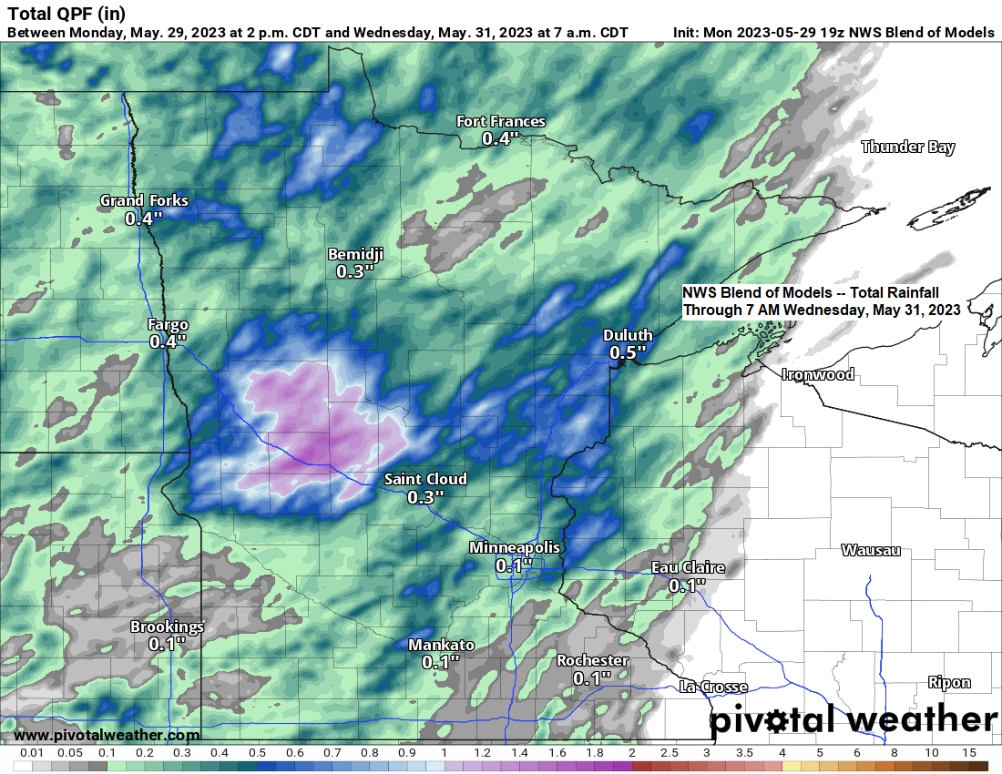
Rainfall totals will likely vary quite a bit across the Northland over the next few days.
Some locations could pick up anywhere from 0.50″ to 2″ of rain through Wednesday morning, while other locations come in shy of a quarter inch of rain.
Here’s the HREF model maximum rainfall totals through 7 AM Wednesday.

HREF model probability-matched mean rainfall totals through 7 AM Wednesday.

There is a Marginal Risk of severe thunderstorms (level 1/5) for Tuesday afternoon/evening covering portions of the Northland (green area on map)
The primary hazard is from hail to 1 inch in diameter (quarter size)

Simulated radar forecasts valid from Midnight tonight to 7 AM Wednesday.
NAM 3km model (18z run)

HRRR model (18z run)

Upper-level ridge which was over the upper Midwest the last few days will remain far enough to the east to allow a more active pattern to setup across the Northland with a southwest flow aloft in place through June 3.

Note — 10 days so far this month with a high of at least 70 in Duluth (average number of days in the 70s in May is 8 days) and we’ve had 3 days so far this month with a high of at least 80 (average number of days in the 80s in May is 2 days)
Temperatures are forecast to remain well above average across the Northland through the end of the week with daytime temperatures in the mid 70s to mid 80s with overnight temps in the 50s and lower 60s. Note — It will be cooler at times near Lake Superior (shocking!)

As we get into next week, we see the pattern readjust a bit as the upper-level ridge pushes farther toward the west setting up more of a northwest flow aloft across the upper Midwest.

Above average temperatures are still expected in the Northland next week, however, even though will see the pattern change a bit.

Tim
Leave a Reply