7:23 PM Wednesday, June 14, 2023
Rain chances for this weekend are diminishing in the Northland.
Overall, a dry pattern continues in the Northland well into next week.
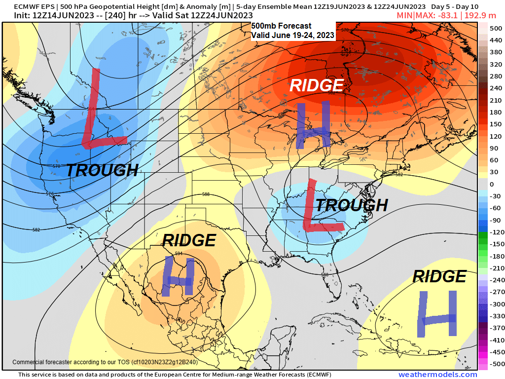
Looking ahead to next week’s pattern features more or less the same pattern we’ve been in for about a month or so. Upper-level ridge strengthens across the upper Midwest and Great Lakes with other ridges farther to the south (one near/over Texas, the other around Bermuda) while upper-level troughs cover parts of the western U.S./northern Rockies and parts of the eastern U.S.
Next week’s pattern is not a favorable pattern for getting rain in northeast Minnesota and northwest Wisconsin as our area will be dominated by the aforementioned upper ridge across the Great Lakes.
Temperature pattern changes little in that will continue to be dealing with persistent east winds and cooler temperatures near Lake Superior while much warmer temperatures continue farther inland with highs in the 80s in much of the Northland this weekend into next week with even a shot at a few 90s on a few days next week.

Heaviest and most widespread rainfall with the system approaching late Friday into Saturday looks to be over southwest Minnesota with mainly scattered showers expected farther north in central and eastern Minnesota Saturday afternoon/night.
It looks like northern Minnesota, North Shore and most of northwest Wisconsin will miss out on getting any rain this weekend.

30-Day percent of normal precipitation.
Red colors=Very Dry

Month to date precipitation totals and percent of normal precipitation in the Northland.
Duluth, MN
Total: 0.04″
Normal: 1.86″
Percent of normal precipitation: 3% of normal
International Falls, MN
Total: 0.05″
Normal: 1.64″
Percent of normal precipitation: 3% of normal
Brainerd, MN
Total: 0.17″
Normal: 1.81″
Percent of normal precipitation: 9% of normal
Ashland, WI
Total: 0.24″
Normal: 1.59″
Percent of normal precipitation: 13% of normal
Hibbing, MN
Total: 0.67″
Normal: 1.82″
Percent of normal precipitation: 37% of normal
Widespread wildfire smoke impacted much of northeast Minnesota and northwest Wisconsin today with a noticeable smoke smell along with reduced visibilities to less than 5 miles due to this smoke.
We have seen some improvement in near surface smoke in parts of the Northland this afternoon as northeast winds help to push the thicker smoke more to the west and south, but higher-level smoke will remain over the Northland at least through Friday morning leading to hazy/milky looking skies.
Goes-16 visible satellite loop from Wednesday, June 14, 2023 (loop time ends 6:41 PM CT)

Air Quality as of 6 PM Wednesday shows very unhealthy (purple) to unhealthy (red) air quality in parts of western Minnesota and over much of central and eastern Minnesota with somewhat better air quality (yellow) in northern Minnesota.

An Air Quality Alert is now in effect until 6 AM Friday for northern and central Minnesota including Duluth.

Looking ahead to Saturday’s weather shows highs in the mid 70s to low 80s in northeast Minnesota and northwest Wisconsin but east winds will keep it cooler closer to Lake Superior with highs in the upper 50s and 60s.
Note — Temperatures around dawn on Saturday are forecast to be around 50 in Duluth with a northeast wind.

Tim
Leave a Reply