6:12 PM Monday, June 19, 2023
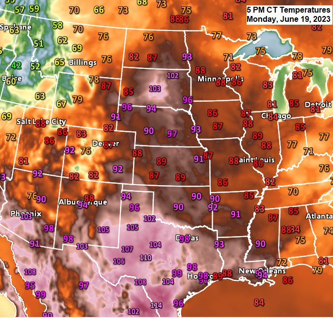
Widespread heat covers a large area from Texas to western Minnesota this afternoon with temperatures in the low to even mid 100s in parts of Texas with 100-degree temperatures as far north as central and northeast South Dakota this afternoon with 90s into western Minnesota. This warmth will persist for several more days with highs in the 80s in northeast Minnesota and northwest Wisconsin from Tuesday through Friday with an isolated 90 degree temperature even possible. A persistent east wind will keep high temperatures in the 60s and 70s closer to Lake Superior through Thursday.
RAIN CHANCES INCREASING LATE THIS WEEK/THIS WEEKEND
A larger scale trough with better lift will be moving east out of the Dakotas this weekend. This system has the potential to bring a more widespread rainfall to the Northland sometime this weekend, with scattered rains possible as early as Friday mainly over north central areas of Minnesota.

500mb forecast valid from June 24-27, 2023 — Note the blue colors which represents lower 500mb heights/troughing moving east out of the Dakotas. This system could bring a period of unsettled weather to the Northland this weekend and possibly even into early next week.

Here’s the NWS Blend of Models rainfall forecast only through 7 AM Saturday.
Rain amounts currently look highest west of Duluth through Saturday morning, with rain chances increasing in Duluth sometime Saturday afternoon or Saturday night, and through the day Sunday.

June 2023 Precipitation Anomalies in the Northland (thru 5 PM on the 19th)
Duluth, MN: -2.54″ below normal
Brainerd, MN: -2.27″ below normal
Ashland, WI: -2.24″ below normal
International Falls, MN: -2.18″ below normal
Hibbing, MN: -1.89″ below normal
June 2023 currently ranks as the driest June on record by climate district in northeastern Minnesota while a top 5 driest June is occurring by climate district in northwestern Wisconsin.
Meanwhile farther to the west in parts of Montana, Wyoming and Colorado we’re seeing the wettest or a top 5 wettest June on record by climate district through June 19.

The 2023 thunderstorm season is off to a very slow start in Duluth with only 3 thunderstorm days so far this year compared to 12 by this time last year.
June 1st was the last time the Duluth Airport had a thunderstorm.
2023 severe weather season is also off to an extremely slow start in the Northland with the NWS in Duluth issuing just 1 warning so far this year (thru June 19th) compared to 53 warnings by this time last year.
Note — 2023 is tied with 1995 for the fewest number of severe thunderstorm + tornado warnings issued in the Northland through June 19.

A very amplified weather pattern continues today with deep troughs over the western U.S. and eastern U.S. while a large and intensifying upper-level ridge covers areas from Texas to areas north of Lake Superior.

Goes-16 water vapor loop from Monday, June 19, 2023 (loop time ends 2:50 PM CT)

Tim
Leave a Reply