6:33 PM Friday, June 23, 2023
Here’s something I haven’t said in a long time — A wet weekend ahead!
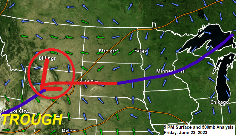
An area of low pressure will move east-northeast out of Wyoming tonight while a cold front over the southern half of Minnesota lifts north as a warm front on Saturday, but this warm front will likely stay south of the Northland. Moisture lifting northward ahead of the Wyoming low and up and over a surface boundary will help generate additional rain as we get into Saturday and Saturday night, and then as the low departs into Wisconsin on Sunday will see additional rain wrap around this system.
To go along with the surface low/fronts will also see a larger scale upper-level trough lift northeast out of the Rockies over the next few days, and the amount of forcing associated with that trough should also help to generate some rain across the Northland this weekend.
By the time we get to Sunday evening much if not all of northeast Minnesota and northwest Wisconsin could see upwards of an inch of rain with higher amounts of 2 to even 3 inches of rain possible in some parts of the area.
Along with the rain this weekend will come another round of wildfire smoke which could mix down to the surface at times especially tonight through Sunday morning.
Duluth area — Some light rain tonight, but then much of the day Saturday might actually be dry before more rain moves in sometime mid or late Saturday afternoon, and this rain could linger through the night and into Sunday.
18z NAM 3km model radar forecast through 7 PM Sunday.

Here’s the NWS Blend of Models rainfall forecast through 7 PM Sunday.

There continues to be a potential for isolated to widely scattered instances of flash flooding in parts of the Northland for Saturday and Saturday night with the greatest risk in the yellow area on the map below.

Pattern change is underway today as we’ve seen clusters of showers and thunderstorms develop while moving northeast across parts of the upper Midwest today. The rain today has been associated with a cold frontal boundary which as of late this afternoon extends from southwest Minnesota to central Wisconsin. Most of the rain today has been developing along and mostly north of that aforementioned cold front.
Goes-16 sandwich satellite loop from Friday, June 23, 2023 (loop time ends 4:56 PM CT)

A much more organized low-pressure system and upper-level trough impacting the central/northern Rockies today will be moving east-northeast through the northern Plains and upper Midwest this weekend, and this system with stronger forcing should help to produce a widespread rain event in the Northland Saturday into Sunday.
Goes-16 water vapor loop from Friday, June 23, 2023 (loop time ends 4:56 PM CT)

***WILDFIRE SMOKE***
There is a potential for another round of more impactful ground level wildfire smoke in northeast Minnesota and northwest Wisconsin late tonight through Sunday morning, however, there is some uncertainty just how bad this smoke will be due to rain at times and also due to increasing NE winds near Lake Superior, those two things may help mix the atmosphere enough to help keep this smoke from getting too bad.
HRRR model near-surface smoke forecast through 7 AM Sunday.
Note — High levels of ground level smoke in orange, red and purple on the animation below.

Tim
Leave a Reply