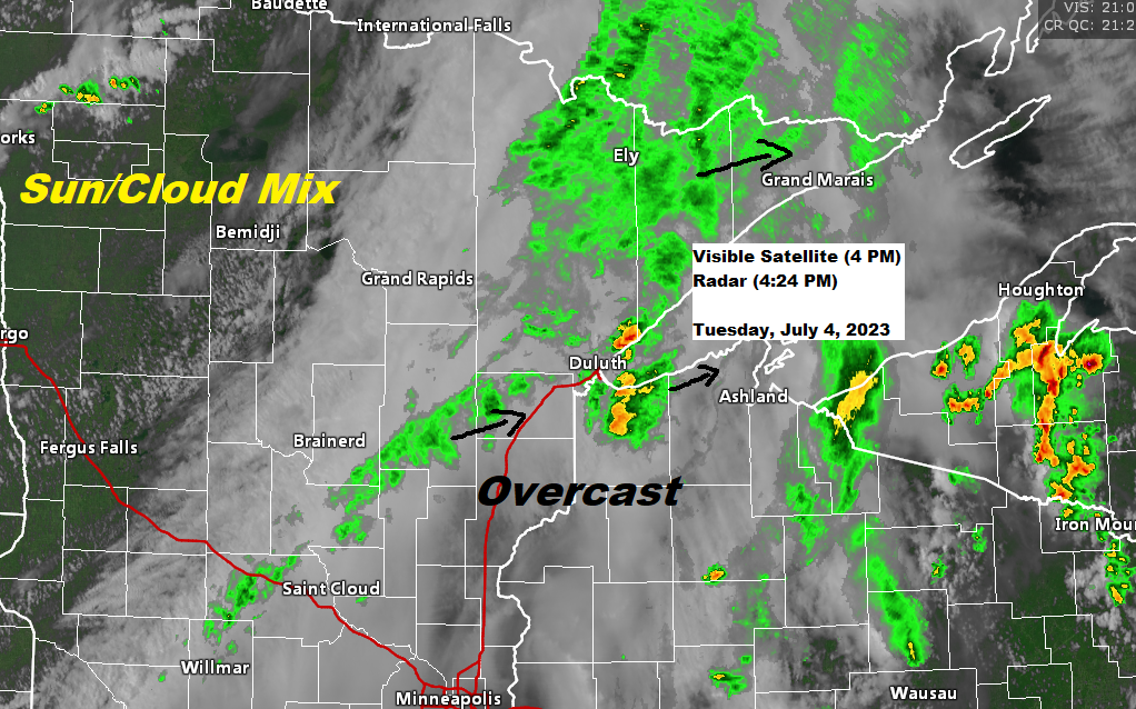
4:31 PM Tuesday, July 4, 2023
Widespread cloudiness covered northeast Minnesota and northwest Wisconsin this afternoon, and the result from all these clouds has been for limited amounts of heating which in turn has led to lower amounts of instability this afternoon. What this all means is that the threat for severe thunderstorms has pretty much ended in eastern Minnesota and northwest Wisconsin through this evening.
Goes-16 visible satellite loop ending 3:46 PM Tuesday, July 4, 2023.

We continue to some showers move northeast across parts of the Northland late this afternoon with some embedded heavier downpours as well.
Radar loop ending 3:50 PM Tuesday, July 4, 2023.

Scattered showers and isolated thunderstorms will likely persist into this evening from northeast Minnesota into northwest Wisconsin, but shower coverage will also be diminishing from SW-NE through the evening hours.
NAM 3km model (18z run) radar forecast through 7 AM Wednesday.


Local Storm Reports from July 3, 2023
Source: National Weather Service Duluth, Minnesota
6:30 PM: Thunderstorm Wind Damage. Springstead, WI (Iron County) Tree down on roadway per law enforcement.
6:15 PM: Thunderstorm Wind Damage. Mercer, WI (Iron County) Tree on the roadway per law enforcement.
6:03 PM: Thunderstorm Wind Damage. Butternut, WI (Ashland County) Powerlines reported down in Butternut due to strong thunderstorm wind gusts.
5:44 PM: Thunderstorm Wind Damage. Glidden, WI (Ashland County) Powerlines reported down in Glidden due to strong thunderstorm winds.
5:35 PM: Thunderstorm Wind Damage. Mellen, WI (Ashland County)
5:30 PM: Hail 0.25 inch. 2 N Clam Lake, WI (Ashland County)
5:26 PM: Hail 0.70 inch. Mason, WI (Bayfield County)
5:01 PM: Thunderstorm Wind Gust 52 mph. 3 SW Ashland, WI (Ashland County)
5:00 PM: Thunderstorm Wind Damage. Cable, WI (Bayfield County) Law enforcement reported a tree fell on a power line in Cable and sparked a small fire which was quickly contained and was under control.
4:51 PM: Thunderstorm Wind Damage. 1 NNW Ashland, WI (Ashland County) Report of a power pole knocked over and caught fire in Ashland due to strong thunderstorm winds.
4:50 PM: Thunderstorm Wind Damage. Barksdale, WI (Bayfield County) Tree of unknown diameter and health reported to be on the road per law enforcement from thunderstorms wind gust.
4:46 PM: Hail 0.88 inch. 3 SSW Drummond, WI (Bayfield County)
4:44 PM: Thunderstorm Wind Damage. Ashland, WI (Ashland County) 8-inch tree limb down.
4:20 PM: Thunderstorm Wind Damage. 1 NE Bayfield, WI (Bayfield County) Report of a power pole that caught fire due to strong thunderstorm winds between Bayfield and Red Cliff.
3:46 PM: Hail 0.25 inch. 1 W Webb Lake, WI (Burnett County)
3:44 PM: Thunderstorm Wind Damage. 2 SSE Siren, WI (Burnett County) Report of about 5 large trees down due to damaging winds. Approximately a foot to foot and a half in diameter. Some trees uprooted, others snapped in half.
3:40 PM: Thunderstorm Wind Gust 39 mph. 1 N Port Wing, WI (Bayfield County)
3:21 PM: Hail 0.75 inch. 1 SSE Yellowlake, WI (Burnett County)
Thanks for reading!
Tim
Leave a Reply