5:49 PM Sunday, August 27, 2023
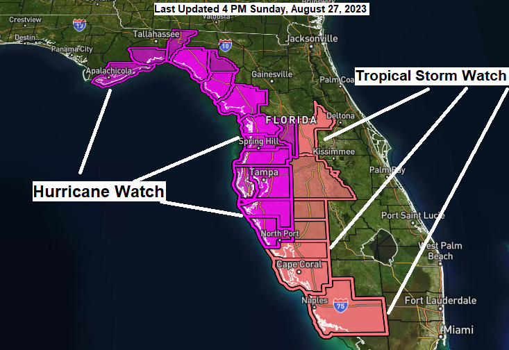
Hurricane Watches have been issued for portions of the west coast of Florida, and the coast of the Florida Panhandle.
There is an increasing risk of life-threatening storm surge and hurricane force winds along portions of the west coast of Florida and the Florida Panhandle beginning as early as Tuesday.
Tropical Storm Watches are in effect a little farther inland in parts of Florida including for parts of the southwest coast of Florida.
Information for Idalia from the National Hurricane Center — 4 PM Sunday Advisory
Location: About 95 miles east-southeast of Cozumel, Mexico
Maximum Sustained Winds: 40 mph
Present Movement: NE at 3 mph
Minimum Central Pressure: 995mb or 29.39″
Latest forecast track of Idalia from the NHC as of late Sunday afternoon.
Note — Red area on the map below represents the cone of uncertainty, with the center of Idalia possibly passing as far west as Apalachicola, FL and Tallahassee, FL, to as far east as Tampa, FL. The solid white represents the most likely track.
Idalia is a Tropical Storm as of 4 PM Sunday, but Idalia is forecast to strengthen to a Hurricane over the eastern Gulf of Mexico Monday night or early Tuesday morning, with the center of Idalia making landfall as a possible category 2 hurricane northwest of Tampa Wednesday morning with winds of 100 mph with maximum wind gusts to 120 mph.

The latest forecast track from the NHC has Idalia making landfall near Shired Island, or between Horseshoe Beach and Cedar Key, FL Wednesday morning.

Tropical Storm Idalia looks a little disorganized late Sunday afternoon, but it does have deep convection associated with it, so a strengthening storm is likely to occur over the next 24 hours or so.
Satellite loop ending 5:27 PM Sunday, August 27, 2023.

Peak Storm Surge Forecast

Arrival time of Tropical Storm Force Winds (39 to 73 mph)

5-Day Rainfall Forecast

Thanks for reading!
Tim
Leave a Reply