6:12 PM Monday, September 4, 2023
Our September heat wave will continue on Tuesday although temperatures won’t be quite as hot as they have been the last few days, and that’s because of more clouds and showers and thunderstorms which will develop and move across the Northland during the day Tuesday, and these showers and thunderstorms will continue Tuesday night with some showers lingering even into Wednesday on the backside of this system. We dry out again late this week into this weekend.
Note — Duluth is running -5.19″ below normal in precipitation this year (through Sept. 4th), while International Falls is running -4.10″ below normal in precipitation.
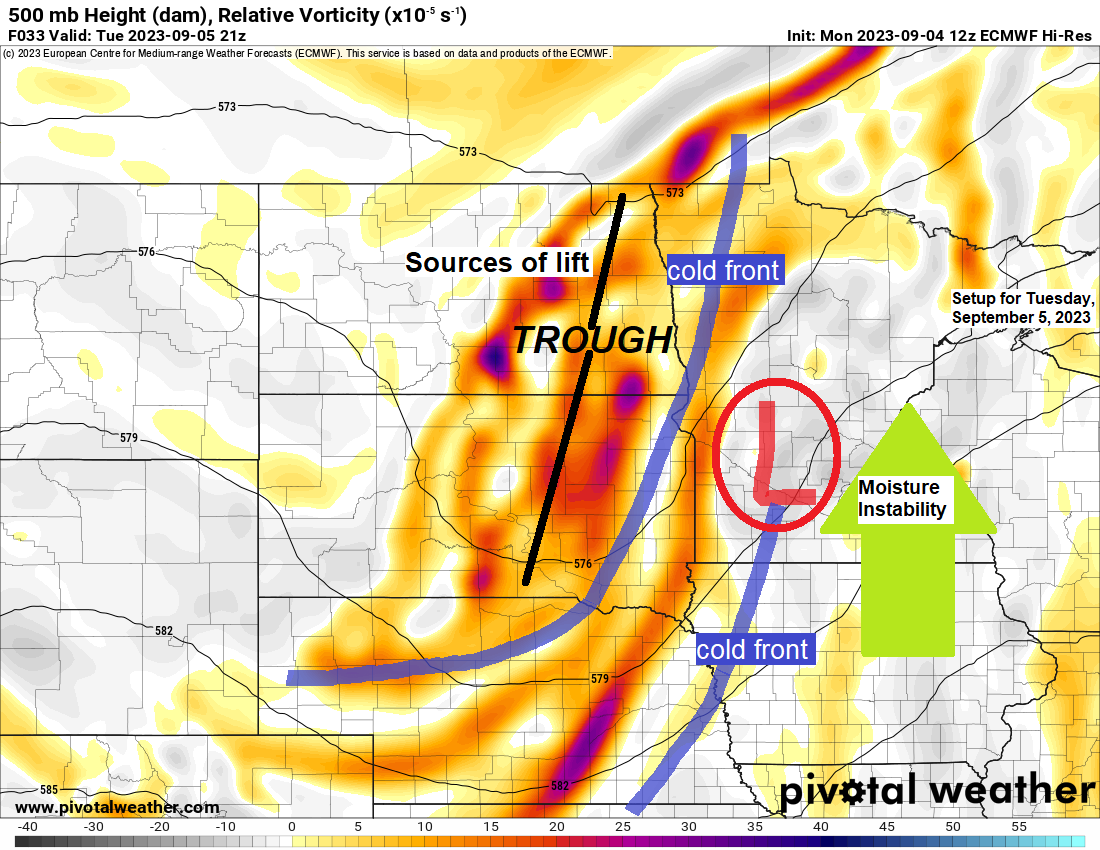
The system moving in on Tuesday is a strong one and is a sure sign that fall is approaching. The amount of lift with this system should be sufficient to see fairly widespread coverage of showers and thunderstorms across the Northland Tuesday/Tuesday night with heavy downpours likely.

Goes-16 water vapor loop from Monday, September 4, 2023 (loop time ends 5:21 PM CT)

Note — It looks like will stay dry in Duluth Tuesday morning through about mid-afternoon Tuesday with chances for showers/thunderstorms increasing mid to late afternoon Tuesday.
NAM 3km model radar forecast valid from 7 AM Tuesday to 1 PM Wednesday.

There is a risk for a few strong to severe thunderstorms in all of northeast Minnesota and northwest Wisconsin Tuesday into Tuesday evening. The primary severe weather threats on Tuesday include damaging wind gusts to 60 mph and large hail to quarter size. Note — The greatest risk for severe storms is in the yellow area on the map below.

***DROUGHT***
The entire Northland needs some rain, but this is especially true in all of northwest Wisconsin, west to the Twin Ports including all of east central Minnesota as these areas continue to be in Severe to Extreme Drought with a small area of Exceptional Drought covering far northwest Wisconsin (South Shore of Lake Superior) so hopefully the system for Tuesday afternoon into Wednesday brings a decent amount of rain to the Northland.

Zoomed out view of the drought monitor as of August 29, 2023, centered on the Northland.

***RAINFALL FORECASTS FOR TUESDAY-WEDNESDAY***
HREF model does show pockets of heavy rain on the order of 1-2″+ totals in parts of northeast Minnesota and northwest Wisconsin Tuesday afternoon into Wednesday morning.

And the probability-matched mean forecast from the HREF model shows widespread 0.50″ to around 2″ of rain across much of the Northland Tuesday afternoon into Wednesday morning.

NWS Blend of Models shows widespread half inch rainfall totals in northeast Minnesota and northwest Wisconsin with localized higher amounts of >1″.

***SEPTEMBER HEAT WAVE***
Northeast winds coming off Lake Superior brought cooler temperatures to locations within about 5 to 10 miles of Lake Superior today with temperatures running about -20 degrees cooler at the Duluth Harbor this afternoon compared to Sunday afternoon.

It was another hot day in much of the Northland today with more record-breaking heat for some. Very warm temperatures continue Tuesday with highs in the 80s to lower 90s, but relief is on the way with much cooler temperatures moving in for Wednesday and Thursday with highs in the upper 50s and 60s.
Here’s a list of the new record high temperatures set today (September 4th)
Brainerd, MN: 97 (previous daily record high was 93 set in 1960)
Ashland, WI: 95 (previous daily record high was 93 set in 1922)
Hibbing, MN: 92 (previous daily record high was 89 set in 1978)
Duluth, MN: 89 — This ties the record high of 89 which was set in 1897 or 126 years ago.
Note — 3 days in the 90s so far this month at Hibbing, Minnesota, this sets a new record for greatest number of days with a high of at least 90 in the month of September at Hibbing. The previous record was 1 day set in multiple years, with the most recent being in 2003. Weather records for Hibbing date back to 1938.

Similar to Sunday, we’re seeing quite a range in dew point temperatures this afternoon, with some locations on the muggy side with dew points in the 60s to lower 70s, while other locations have seen their dew point fall into the 50s (much drier)

***RECORD HIGHS FOR SEPTEMBER 5TH***
Ashland, WI: 94 set in 1908 and 1912
Duluth, MN: 90 set in 1947
Hibbing, MN: 88 set in 1947 and 1998
Thanks for reading!
Tim
Leave a Reply